Category:South Norwood
Jump to navigation
Jump to search
district of south east London, England  | |||||
| Upload media | |||||
| Instance of | |||||
|---|---|---|---|---|---|
| Location | London Borough of Croydon, Greater London, London, England | ||||
 | |||||
Subcategories
This category has the following 14 subcategories, out of 14 total.
A
- Apsley Road Playground (1 F)
H
- Heavers Meadow (6 F)
L
M
N
P
- Penge Road, Anerley (1 F)
S
- South Norwood clock tower (10 F)
- South Norwood Library (4 F)
W
Media in category "South Norwood"
The following 32 files are in this category, out of 32 total.
-
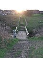 Bridge over stream at Brickfields Meadow.jpg 2,136 × 2,848; 2.81 MB
-
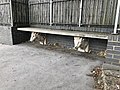 Goat House Bridge bench.jpg 2,016 × 1,512; 1.31 MB
-
 Harris Academy South Norwood.jpg 1,600 × 1,067; 198 KB
-
 Harris City Academy Crystal Palace.jpg 700 × 467; 81 KB
-
 Interior of Arriva London EMC1 on Route 312, Norwood Junction (15871113310).jpg 3,264 × 2,448; 2.77 MB
-
 Langdale Rd - geograph.org.uk - 3541691.jpg 640 × 430; 55 KB
-
 Malvern Rd - geograph.org.uk - 3541680.jpg 640 × 430; 64 KB
-

-
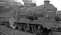
 Norwood Locomotive Depot geograph-2649644-by-Ben-Brooksbank.jpg 1,197 × 702; 317 KB
-
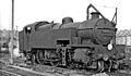
 Norwood Locomotive Depot Q Class geograph-2979640-by-Ben-Brooksbank.jpg 2,362 × 1,377; 1.03 MB
-
 Norwood Locomotive Depot W Class geograph-2982241-by-Ben-Brooksbank.jpg 2,394 × 1,395; 1.2 MB
-

-

-

-

-

-

-

-

-

-

-

-
 Snowy Landscape at South Norwood.jpg 2,744 × 2,266; 4.67 MB
-
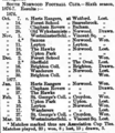 South Norwood F.C.'s results in 1876-77.png 820 × 948; 712 KB
-
 South Norwood Lake.JPG 1,024 × 768; 152 KB
-
 South Norwood's Stone Of Croydon.jpg 4,032 × 3,024; 4.92 MB
-
 South Norwood, Cargreen Road - geograph.org.uk - 1921095.jpg 3,456 × 2,304; 5.52 MB
-
 South Norwood, Lawrence Road - geograph.org.uk - 1921076.jpg 3,456 × 2,304; 5.17 MB
-
 South Norwood, SE25 The Beehive PH.jpg 3,072 × 2,304; 1.35 MB
-
 South Norwood, Station Road - geograph.org.uk - 1921146.jpg 3,456 × 2,304; 5.56 MB
-
 South Norwood, The 'Cherry Trees' - geograph.org.uk - 1921114.jpg 3,456 × 2,304; 5.29 MB
-
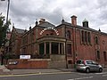 Stanley Halls, South Norwood.jpg 3,264 × 2,448; 2.08 MB


.jpg)


_(14596750580).jpg)


