Category:Spanish-language maps of the United States
Jump to navigation
Jump to search
Subcategories
This category has only the following subcategory.
Media in category "Spanish-language maps of the United States"
The following 17 files are in this category, out of 17 total.
-
 2010 Census map by population change - MS - es.svg 765 × 990; 1.15 MB
-
 Adquisiciones territoriales de los Estados Unidos.svg 734 × 501; 1.49 MB
-
 Cartograma democrata.jpg 2,080 × 1,180; 196 KB
-
 DelegadosRepublicanos2008.jpg 1,490 × 800; 142 KB
-
 ESP Black Moshannon State Park Map.PNG 457 × 600; 89 KB
-
 Map of USA with state names es.svg 959 × 593; 407 KB
-
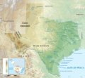 MapaTopográficoDeTexasGeografíaFísica.svg 2,164 × 2,000; 7.39 MB
-
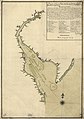 Plano de la Bahia de la Ware y entrada de Filadelfie ... LOC 73691796.jpg 6,098 × 8,672; 6.05 MB
-
 Second Seminole War map-es.svg 800 × 1,115; 247 KB
-
 Spanish spoken at home in the United States - 2015 - es.svg 1,023 × 633; 166 KB
-
 Spanish spoken at home in the United States - es.svg 959 × 593; 158 KB
-
 Texas topographic map-es.svg 2,164 × 2,000; 14.83 MB
-
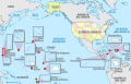 United States (+overseas), administrative divisions - es - colored (zoom).svg 1,339 × 864; 5.36 MB
-
 United States 1803-04-1804-03-es.svg 734 × 501; 2.02 MB
-
 United States 2022 FIFA World Cup host cities-es.svg 959 × 593; 256 KB
-
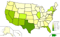
 United States Electoral College-es.svg 1,189 × 593; 346 KB
-
 United States, administrative divisions - es - colored.svg 1,181 × 731; 3.22 MB


,_administrative_divisions_-_es_-_colored_(zoom).svg)


