Category:Speicher (Bürenstrasse 24, Leuzigen)
Jump to navigation
Jump to search
| Object location | | View all coordinates using: OpenStreetMap |
|---|
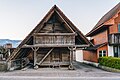
rural storage building in Leuzigen in the canton of Bern, Switzerland  | |||||
| Upload media | |||||
| Instance of | |||||
|---|---|---|---|---|---|
| Part of | |||||
| Location | Leuzigen, Seeland administrative district, Seeland administrative region, Bern, Switzerland | ||||
| Street address |
| ||||
| Heritage designation |
| ||||
| Inception |
| ||||
 | |||||
Media in category "Speicher (Bürenstrasse 24, Leuzigen)"
This category contains only the following file.
-
 Holzhaus Bürenstrasse.jpg 5,353 × 3,569; 12.13 MB