Category:Speicher Nr. 48, Möriswil
Jump to navigation
Jump to search
| Object location | | View all coordinates using: OpenStreetMap |
|---|
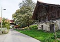
rural building in Möriswil in the canton of Bern, Switzerland  | |||||
| Upload media | |||||
| Instance of | |||||
|---|---|---|---|---|---|
| Part of | |||||
| Location | Möriswil, Wohlen bei Bern, Bern-Mittelland administrative district, Bernese Mittelland administrative region, Bern, Switzerland | ||||
| Street address |
| ||||
| Architectural style |
| ||||
| Heritage designation | |||||
| Inception |
| ||||
| Elevation above sea level |
| ||||
 | |||||
Media in category "Speicher Nr. 48, Möriswil"
The following 6 files are in this category, out of 6 total.
-
 Möriswil, Speicher Nr.48 2.jpg 4,320 × 3,240; 1.73 MB
-
 Möriswil, Speicher Nr.48 3.jpg 3,973 × 2,980; 10.09 MB
-
 Möriswil, Speicher Nr.48 Sockel.jpg 4,187 × 3,140; 6.53 MB
-
 Möriswil. Speicher Nr.48.jpg 4,320 × 3,240; 4.41 MB
-
 Möriswil2018 (2).jpg 5,595 × 3,730; 14.27 MB
-
 Möriswil2018 (3).jpg 5,537 × 3,839; 14.99 MB


.jpg)
.jpg)