Category:Spritzenhaus Falkenthal
Jump to navigation
Jump to search
| Object location | | View all coordinates using: OpenStreetMap |
|---|
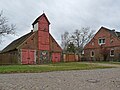
Former firestation in Oberhavel district, Brandenburg state, Germany | |||||
| Upload media | |||||
| Instance of | |||||
|---|---|---|---|---|---|
| Location | Falkenthal, Löwenberger Land, Oberhavel District, Brandenburg, Germany | ||||
| Street address |
| ||||
| Heritage designation | |||||
| Inception |
| ||||
 | |||||
This is the category of the Brandenburger Baudenkmal (cultural heritage monument) with the ID 09165451 (Wikidata)
|
English: Pictures of the former extinguisher station in Falkenthal, Löwenberger Land municipality, Oberhavel district, Brandenburg state, Germany.
Deutsch: Ansichten des früheren Spritzenhauses in Falkenthal, Gemeinde Löwenberger Land , Landkreis Oberhavel , Land Brandenburg , Deutschland.
Français : Photos de l'ancien depôt des pompiers à Falkenthal, commune de Löwenberger Land, , arrondissement de Oberhavel , état federé de Brandebourg , Allemagne.
Español: Vistas del antiguo parque de bomberos en Falkenthal, municipio de Löwenberger Land, distrito de Oberhavel , estado federado de Brandeburgo , Alemania.
Address: Liebenwalder Straße 9, 16775 Löwenberger Land - Falkenthal
Media in category "Spritzenhaus Falkenthal"
The following 2 files are in this category, out of 2 total.
-
 Feuerwehr Falkenthal.jpg 3,648 × 2,736; 2.82 MB
-
 Spritzenhaus Falkenthal 2021 NE.jpg 4,670 × 3,502; 1.91 MB

