Category:St Peter's Church, Chellaston
Jump to navigation
Jump to search
| Object location | | View all coordinates using: OpenStreetMap |
|---|
church in Chellaston, Derbyshire, England, UK  | |||||
| Upload media | |||||
| Instance of | |||||
|---|---|---|---|---|---|
| Dedicated to | |||||
| Location | Chellaston, City of Derby, Derbyshire, East Midlands, England | ||||
| Diocese | |||||
| Heritage designation |
| ||||
| Religion or worldview | |||||
 | |||||
Media in category "St Peter's Church, Chellaston"
The following 6 files are in this category, out of 6 total.
-
 St Peter Chellaston.jpg 2,176 × 3,264; 3.7 MB
-
 St Peter's Church in Chellaston - geograph.org.uk - 3834035.jpg 3,938 × 2,916; 1.86 MB
-
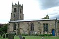
 St Peter's Church, Chellaston - geograph.org.uk - 287970.jpg 640 × 426; 94 KB
-
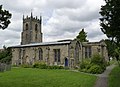
 St Peter's church, Chellaston - geograph.org.uk - 3213092.jpg 1,600 × 1,067; 314 KB
-
 St Peter's Church, Chellaston - geograph.org.uk - 3642298.jpg 1,280 × 930; 247 KB
-
 St. Peter's Church at Midday Christmas 2013 - geograph.org.uk - 3789388.jpg 1,200 × 900; 163 KB


