Category:St. Ägidius (Türkenfeld)
Jump to navigation
Jump to search
| Object location | | View all coordinates using: OpenStreetMap |
|---|
| Upload media | |||||
| Instance of | |||||
|---|---|---|---|---|---|
| Location | Hohenthann, Landshut, Lower Bavaria, Bavaria, Germany | ||||
| Street address |
| ||||
| Has part(s) |
| ||||
| Heritage designation | |||||
 | |||||
This is the category of the Bavarian Baudenkmal (cultural heritage monument) with the ID D-2-74-141-34 (Wikidata)
|
Media in category "St. Ägidius (Türkenfeld)"
The following 9 files are in this category, out of 9 total.
-
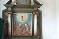 Hohenthann-Türkenfeld-Kirche-Allerseelenaltar.jpg 1,760 × 1,168; 586 KB
-
 Hohenthann-Türkenfeld-Kirche-Innenraum.jpg 1,760 × 1,168; 564 KB
-
 Hohenthann-Türkenfeld-Kirche-Seelenkapelle.jpg 1,760 × 1,168; 429 KB
-
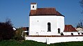
 Hohenthann-Türkenfeld-Kirche-Südansicht.jpg 1,760 × 1,168; 355 KB
-
 Hohenthann-Türkenfeld-Kirche-Westempore.jpg 1,760 × 1,168; 496 KB
-
 Schloss Türkenfeld (Hohenthann).PNG 672 × 427; 758 KB
-
 St Aegidius Tuerkenfeld.jpg 885 × 768; 123 KB
-
 Türkenfeld St. Aegidius 01.jpg 2,592 × 1,458; 2.39 MB
-
 Türkenfeld St. Aegidius 02.jpg 2,544 × 1,694; 2.47 MB


.PNG)


