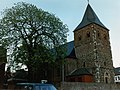
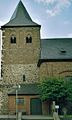
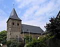
Category:St. Aldegundis (Rheindorf)
Jump to navigation
Jump to search
| Object location | | View all coordinates using: OpenStreetMap |
|---|
 | |||||
| Upload media | |||||
| Instance of | |||||
|---|---|---|---|---|---|
| Location | Leverkusen, Cologne Government Region, North Rhine-Westphalia, Germany | ||||
| Architectural style | |||||
| Heritage designation | |||||
 | |||||
Media in category "St. Aldegundis (Rheindorf)"
The following 17 files are in this category, out of 17 total.
-
 Rheindorf 01.jpg 1,024 × 768; 1.09 MB
-
 Rheindorf, Katholische Pfarrkirche.jpg 697 × 1,166; 380 KB
-
 St. Aldegundis (Rheindorf) (1).jpg 3,286 × 2,884; 3.1 MB
-
 St. Aldegundis (Rheindorf) (10).jpg 4,032 × 3,024; 4 MB
-
 St. Aldegundis (Rheindorf) (11).jpg 4,032 × 3,024; 3.93 MB
-
 St. Aldegundis (Rheindorf) (12).jpg 3,024 × 4,032; 4.33 MB
-
 St. Aldegundis (Rheindorf) (2).jpg 3,058 × 2,958; 5.33 MB
-
 St. Aldegundis (Rheindorf) (3).jpg 3,704 × 3,012; 5.46 MB
-
 St. Aldegundis (Rheindorf) (4).jpg 3,024 × 4,032; 5.12 MB
-
 St. Aldegundis (Rheindorf) (5).jpg 4,032 × 3,024; 6.75 MB
-
 St. Aldegundis (Rheindorf) (6).jpg 3,024 × 4,032; 5.45 MB
-
 St. Aldegundis (Rheindorf) (7).jpg 3,048 × 3,012; 5.76 MB
-
 St. Aldegundis (Rheindorf) (8).jpg 3,866 × 2,814; 6.64 MB
-
 St. Aldegundis (Rheindorf) (9).jpg 3,866 × 2,948; 6.07 MB
-
 St. Aldegundis Leverkusen-Rheindorf1.JPG 1,868 × 1,460; 734 KB
-
 St. Aldegundis Leverkusen-Rheindorf2.JPG 1,259 × 1,917; 767 KB
-
 St. Anna Kapelle (Leverkusen) (2).jpg 2,388 × 1,605; 1.01 MB


_(1).jpg)
_(10).jpg)
_(11).jpg)
_(12).jpg)
_(2).jpg)
_(3).jpg)
_(4).jpg)
_(5).jpg)
_(6).jpg)
_(7).jpg)
_(8).jpg)
_(9).jpg)

_(2).jpg)