Category:St. Bartholomäus (Frengkofen)
Jump to navigation
Jump to search
| Object location | | View all coordinates using: OpenStreetMap |
|---|
church building in Bach an der Donau, Upper Palatinate, Germany   | |||||
| Upload media | |||||
| Instance of | |||||
|---|---|---|---|---|---|
| Location | Bach an der Donau, Regensburg, Upper Palatinate, Bavaria, Germany | ||||
| Street address |
| ||||
| Heritage designation | |||||
 | |||||
This is the category of the Bavarian Baudenkmal (cultural heritage monument) with the ID D-3-75-116-9 (Wikidata)
|
Media in category "St. Bartholomäus (Frengkofen)"
The following 12 files are in this category, out of 12 total.
-
 Bach-Frengkofen-Kirche-Sankt-Bartholomäus.jpg 3,264 × 2,448; 2.06 MB
-
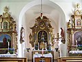
 Frengkofen Sankt Bartholomäus Chorraum.jpg 3,264 × 2,448; 2.01 MB
-
 Frengkofen Sankt Bartholomäus Hochaltar Mittelteil.jpg 3,264 × 2,448; 2.77 MB
-
 Frengkofen Sankt Bartholomäus Hochaltar-Auszug.jpg 3,264 × 2,448; 2.45 MB
-
 Frengkofen Sankt Bartholomäus Hochwassermarke.jpg 3,264 × 2,448; 2.58 MB
-
 Frengkofen Sankt Bartholomäus Innenraum.jpg 3,264 × 2,448; 2.11 MB
-
 Frengkofen Sankt Bartholomäus Kanzel.jpg 3,264 × 2,448; 1.97 MB
-
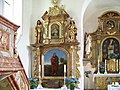 Frengkofen Sankt Bartholomäus linker Seitenaltar.jpg 3,264 × 2,448; 2.07 MB
-
 Frengkofen Sankt Bartholomäus Madonna.jpg 3,264 × 2,448; 1.77 MB
-
 Frengkofen Sankt Bartholomäus Orgellempore.jpg 3,264 × 2,448; 1.75 MB
-
 Frengkofen Sankt Bartholomäus Portal.jpg 3,264 × 2,448; 1.47 MB
-
 Frengkofen Sankt Bartholomäus rechter Seitenaltar.jpg 3,264 × 2,448; 2.08 MB


