Category:St. Bernhard (Brual)
Jump to navigation
Jump to search
| Object location | | View all coordinates using: OpenStreetMap |
|---|
| Upload media | |||||
| Instance of | |||||
|---|---|---|---|---|---|
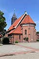
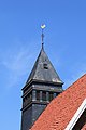
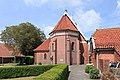
| Location | Rhede (Ems), Emsland, Lower Saxony, Germany | ||||
 | |||||
Subcategories
This category has only the following subcategory.
I
- Interior of St. Bernhard (Brual) (19 F)
Media in category "St. Bernhard (Brual)"
The following 15 files are in this category, out of 15 total.
-
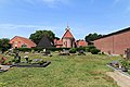 Rhede Brual - Dorfstraße - Friedhof + St. Bernhard 01 ies.jpg 5,616 × 3,744; 21.62 MB
-
 Rhede Brual - Dorfstraße - St. Bernhard 01 ies.jpg 3,743 × 5,616; 16.11 MB
-
 Rhede Brual - Dorfstraße - St. Bernhard 02 ies.jpg 3,744 × 5,616; 20.08 MB
-
 Rhede Brual - Dorfstraße - St. Bernhard 03 ies.jpg 5,616 × 3,744; 21.55 MB
-
 Rhede Brual - Dorfstraße - St. Bernhard 04 ies.jpg 5,616 × 3,744; 21.6 MB
-
 Rhede Brual - Dorfstraße - St. Bernhard 05 ies.jpg 3,744 × 5,616; 20.34 MB
-
 Rhede Brual - Dorfstraße - St. Bernhard 06 ies.jpg 5,616 × 3,744; 20.01 MB
-
 Rhede Brual - Dorfstraße - St. Bernhard 07 ies.jpg 3,744 × 5,616; 20.74 MB
-
 Rhede Brual - Dorfstraße - St. Bernhard 08 ies.jpg 3,744 × 5,616; 15.99 MB
-
 Rhede Brual - Dorfstraße - St. Bernhard 09 ies.jpg 5,616 × 3,744; 21.08 MB
-
 Rhede Brual - Dorfstraße - St. Bernhard 10 ies.jpg 5,616 × 3,744; 16.41 MB
-
 Rhede Brual - Dorfstraße - St. Bernhard 11 ies.jpg 5,616 × 3,743; 20.12 MB
-
 Rhede Brual - Dorfstraße - St. Bernhard 12 ies.jpg 5,616 × 3,744; 21.47 MB
-
 Rhede Brual - Dorfstraße - St. Bernhard 13 ies.jpg 5,616 × 3,744; 21.01 MB
-
 Rhede Brual - Dorfstraße - St. Bernhard 14 ies.jpg 5,616 × 3,745; 21.06 MB


