Category:St. Clemens (Sterkrade)
Jump to navigation
Jump to search
| Object location | | View all coordinates using: OpenStreetMap |
|---|
| Upload media | |||||
| Instance of | |||||
|---|---|---|---|---|---|
| Named after | |||||
| Location | Sterkrade, Oberhausen, Düsseldorf Government Region, North Rhine-Westphalia, Germany | ||||
| Religion or worldview | |||||
 | |||||
Media in category "St. Clemens (Sterkrade)"
The following 8 files are in this category, out of 8 total.
-
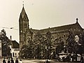 Alt St Clemens (Oberhausen-Sterkrade).jpg 4,032 × 3,024; 2.6 MB
-
 OB-St Clemens.jpg 3,456 × 4,608; 4.14 MB
-
 Prospekt der Walcker Orgel der Propsteikirche St. Clemens Oberhausen-Stekrade.jpg 4,032 × 3,024; 1.84 MB
-
 Prospekt der Walcker Orgel der Propsteikirche St. Clemens Oberhausen-Sterkrade 2.jpg 4,032 × 3,024; 1.74 MB
-
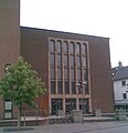
 St Clemens Oberhausen-Sterkrade.jpg 4,032 × 3,024; 2.53 MB
-
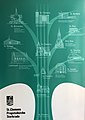 St. Clemens History.jpg 2,823 × 3,999; 2.52 MB
-
 St. Clemens Kirche Oberhausen Sterkrade an der Frohnleichnahmskirmes - panoramio.jpg 1,200 × 1,600; 396 KB
-
 St.Clemens Kirche Oberhausen-Sterkrade.jpg 1,176 × 1,218; 71 KB
.jpg)


Categories:
- Churches in Sterkrade
- Saint Clemens churches in North Rhine-Westphalia
- Churches in Dekanat Oberhausen
- Churches in North Rhine-Westphalia built in 1953
- 1950s brick churches in North Rhine-Westphalia
- Parish churches in North Rhine-Westphalia
- 1950s churches in Regierungsbezirk Düsseldorf
- Heimatschutz churches in Regierungsbezirk Düsseldorf
- Heimatschutz brick churches in Regierungsbezirk Düsseldorf