Category:St. George, Utah
Jump to navigation
Jump to search
city in Washington County, Utah, United States     | |||||
| Upload media | |||||
| Instance of | |||||
|---|---|---|---|---|---|
| Named after | |||||
| Location | Washington County, Utah | ||||
| Located in or next to body of water | |||||
| Head of government |
| ||||
| Inception |
| ||||
| Population |
| ||||
| Area |
| ||||
| Elevation above sea level |
| ||||
| official website | |||||
 | |||||
English: Media related to St. George, Utah, a city located in southern Washington County in the southwestern part of Utah, United States on the Utah-Arizona border, near the tri-state junction of Utah, Nevada and Arizona.
Subcategories
This category has the following 13 subcategories, out of 13 total.
2
B
C
- City Creek (Santa Clara River) (empty)
H
M
- Middleton, Utah (6 F)
N
P
S
T
- Thunder Over Utah (12 F)
Media in category "St. George, Utah"
The following 151 files are in this category, out of 151 total.
-
 1914 D Sugarloaf.jpg 540 × 405; 45 KB
-
 1st Gate.JPG 512 × 341; 41 KB
-
 2013-09-21 11 19 21 View north along Interstate 15 in Utah near milepost 5.5.JPG 3,264 × 2,448; 2.39 MB
-
 2017.05.07 12.11.29 IMG 0619 - Flickr - andrey zharkikh.jpg 5,184 × 3,888; 2.51 MB
-
 Airfield, Municipal Airport (St George, Utah).jpg 1,526 × 600; 161 KB
-

-
 Arizona State Route 389 map.svg 1,001 × 586; 89 KB
-
 Atop the 'Dixie Sugarloaf' on the outskirts of St. George, Utah - (22392246237).jpg 8,253 × 5,502; 39.83 MB
-
 Atop the 'Dixie Sugarloaf' on the outskirts of St. George, Utah - (22392273488).jpg 7,646 × 5,097; 29.35 MB
-

-

-

-

-

-

-
 B-DogPractice.jpg 2,816 × 2,112; 2.58 MB
-
 BL-15 South and UT-34 West Shields - panoramio.jpg 1,600 × 1,200; 380 KB
-
 BL-15-UT-34 Dual Signage - panoramio.jpg 1,600 × 1,200; 585 KB
-
 BL-15-UT-34 Signage - panoramio.jpg 1,600 × 1,200; 438 KB
-
 BL-15-UT-34, Exit 8 off of I-15 in St. George, UT - panoramio.jpg 1,600 × 1,200; 316 KB
-
 Bronze Statue on Main St.jpg 1,280 × 860; 150 KB
-
 Brooks the Bison.jpg 4,032 × 3,024; 5.23 MB
-
 California Fan Palms, St. George, Utah.jpg 1,280 × 960; 363 KB
-
 Canary Palm.jpg 960 × 944; 157 KB
-
 City Hall (St George, Utah).jpg 1,533 × 891; 252 KB
-
 Classic NMC T-shirt (4708302046).jpg 2,376 × 1,581; 1.17 MB
-

-
 CtyMapWashington.png 936 × 689; 35 KB
-
 Date Palm in St. George Utah.jpg 720 × 960; 82 KB
-
 DIXIE writtten over 1914.jpg 540 × 405; 61 KB
-
 Downtown st george utah.jpg 1,000 × 750; 270 KB
-
 Driving Utah, I-15 N near St. George 2014 (29311466936).jpg 2,800 × 1,208; 1.32 MB
-
 Dtn st george.jpg 800 × 533; 149 KB
-
 East UT-34 - panoramio.jpg 1,600 × 1,200; 469 KB
-
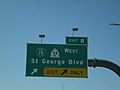
 East UT-34 Shield (St. George Blvd.) - panoramio.jpg 1,600 × 1,200; 544 KB
-
 Echinocactus grusonii, Red Hills Desert Garden, St. George, UT, USA.jpg 4,752 × 3,168; 6.89 MB
-
 EM ME on the mountain at St. George Airport (2190915657).jpg 2,560 × 1,920; 1.66 MB
-
 EM ST. GEORGE, UTAH (2624012794).jpg 3,872 × 2,592; 4.42 MB
-
 EM St. George, Utah (2820719164).jpg 3,872 × 2,592; 3.26 MB
-
 END UT-34 at UT-18, TO I-15 - panoramio.jpg 1,600 × 1,200; 666 KB
-
 END UT-34 Shield - panoramio.jpg 1,600 × 1,200; 455 KB
-
 END UT-8, UT-18, and TO I-15 Shields - panoramio.jpg 1,600 × 1,200; 530 KB
-
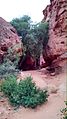
 Entrance to St George Narrows dyeclan.com - panoramio.jpg 2,448 × 3,264; 3.64 MB
-
 Erastus Snow - Flickr - brewbooks.jpg 3,264 × 2,340; 3.37 MB
-
 Eubrontes01.JPG 1,000 × 1,450; 475 KB
-
 Evening, St. George, Utah.jpg 15,651 × 7,905; 92.91 MB
-
 Fiery Sandstone-2.jpg (11226288466).jpg 2,783 × 1,077; 3.37 MB
-
 Fire department (St George, Utah).jpg 1,439 × 771; 192 KB
-
 First Westbound UT-34 Shield - panoramio.jpg 1,600 × 1,200; 495 KB
-
 George Washington Academy.jpg 2,225 × 1,669; 176 KB
-
 Hills by Hwy 18 - panoramio.jpg 1,280 × 960; 334 KB
-

-

-
 Honeymoon Trail - Flickr - brewbooks.jpg 1,297 × 2,830; 1.58 MB
-
 Lane Turnings to I-15 - panoramio.jpg 1,600 × 1,200; 352 KB
-
 Larrea tridentata, Red Hills Desert Garden, St. George, UT, USA.jpg 4,752 × 3,168; 5.09 MB
-
 Main Street Utah.JPG 800 × 534; 195 KB
-
 Matt Keddington climbing the 'D'..jpg 420 × 420; 40 KB
-
 Mex fan.jpg 720 × 960; 103 KB
-
 Mountain Meadows BHoU-p550.png 1,760 × 3,126; 156 KB
-
 Municipal Airport Passenger Terminal (St George, Utah).jpg 1,005 × 944; 188 KB
-
 My Public Lands Magazine, Spring 2015 (16008925623).jpg 1,140 × 760; 185 KB
-
 My Public Lands Magazine, Spring 2015 (16421393557).jpg 1,249 × 803; 58 KB
-
 My Public Lands Magazine, Spring 2015 (16602719706).jpg 1,004 × 760; 113 KB
-
 My Public Lands Magazine, Spring 2015 (16627591481).jpg 1,245 × 760; 120 KB
-
 North UT-18 after UT-34 - panoramio.jpg 1,600 × 1,200; 438 KB
-
 Overlook of Main St. St. George.jpg 1,280 × 857; 186 KB
-
 Overlook of St. George, Utah.jpg 1,800 × 598; 446 KB
-
 Panorama of St.George Utah.jpg 4,336 × 944; 1.2 MB
-
 Photo of St.George Utah.jpg 4,128 × 3,096; 1.69 MB
-
 Pindo Palm. St. George Utah.jpg 715 × 960; 117 KB
-
 Pine Valley Mountains St George banner.jpg 2,100 × 300; 323 KB
-
 Pine Valley Mountains.jpg 5,360 × 2,100; 3.73 MB
-
 Pioneer Park, St. George Utah.jpg 1,836 × 3,264; 1.72 MB
-
 Pioneerhomenearstgeorge.jpg 1,280 × 1,024; 377 KB
-
 Police department (St George, Utah).jpg 1,488 × 882; 181 KB
-
 Ponte exa.png 160 × 160; 22 KB
-
 Punchbowl Dome 1.jpg 2,400 × 1,600; 799 KB
-
 Race and ethnicity 2020 St. George, UT.png 2,400 × 2,404; 1.2 MB
-
 Rainy Day in St. George.jpg 2,340 × 4,160; 2.43 MB
-
 Seal of the City of St. George.png 350 × 97; 9 KB
-
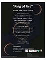 Solar Eclipse Flyer (7176373810).jpg 1,275 × 1,650; 192 KB
-
 Souhern Utah Wild Palm.jpg 720 × 960; 104 KB
-
 SOUTH UT-18 TO I-15 Shields - panoramio.jpg 1,600 × 1,200; 317 KB
-
 Southern Utah map c. 1857, Bancroft p. 550.PNG 332 × 563; 43 KB
-
 St George panorama.jpg 10,460 × 1,900; 6.83 MB
-
 St George Utah city limits 1.jpg 2,400 × 1,600; 619 KB
-
 St George Utah from east 1.jpg 2,400 × 1,600; 638 KB
-
 St George Utah River Road area 1.jpg 2,400 × 1,600; 791 KB
-
 St George Utah south 1.jpg 2,400 × 1,600; 748 KB
-
 St George, Utah in the fall - (11226451934).jpg 2,121 × 1,414; 3.24 MB
-
 St George, Utah in the fall - (11226457206).jpg 2,121 × 1,414; 2.46 MB
-
 St George, Utah in the fall - (11226580873).jpg 2,121 × 1,414; 3.98 MB
-
 St George, Utah in the fall - gorgeous evening light (11226466966).jpg 2,121 × 1,414; 3.65 MB
-
 St George, Utah in the fall - gorgeous evening light (11226499526).jpg 1,414 × 2,121; 3.27 MB
-

-
 St George, Utah panorama.jpg 3,008 × 997; 4.01 MB
-
 St. george utah pic.JPG 3,264 × 2,448; 1.56 MB
-
 St. George - panoramio.jpg 2,048 × 1,536; 1.04 MB
-
 St. George BL-15 Turn - panoramio.jpg 1,600 × 1,200; 426 KB
-
 St. George Boulevard.jpg 1,367 × 2,048; 276 KB
-
 St. George DDI 2 - panoramio.jpg 1,600 × 1,200; 341 KB
-
 St. George DDI 3 - panoramio.jpg 1,600 × 1,200; 480 KB
-
 St. George DDI 4 - panoramio.jpg 1,600 × 1,200; 345 KB
-
 St. George DDI 5 - panoramio.jpg 1,600 × 1,200; 339 KB
-
 St. George DDI 7 - panoramio.jpg 1,600 × 1,200; 291 KB
-
 St. George DDI 8 - panoramio.jpg 1,600 × 1,200; 293 KB
-
 St. George Exit 8 DDI 1 - panoramio.jpg 1,600 × 1,200; 326 KB
-
 St. George from United 653 (8396385895).jpg 935 × 1,600; 560 KB
-
 St. George Overlook.jpg 1,280 × 832; 228 KB
-
 St. George Sunset.jpg 1,280 × 851; 117 KB
-
 St. George Utah Orange tree.jpg 720 × 960; 108 KB
-
 St. George Utah, Mexican Blue Palm.jpg 720 × 960; 127 KB
-
 St. George Utah, Pine Vallet Mt.jpg 720 × 960; 77 KB
-
 St. George, UT, I-15N (6003024708).jpg 960 × 1,044; 172 KB
-
 St. George, Utah (101362612).jpg 1,600 × 1,200; 695 KB
-
 St. George, Utah (67175257).jpg 2,048 × 1,536; 1.16 MB
-
 St. George, Utah (68915031).jpg 1,280 × 960; 114 KB
-
 St. George, Utah (68915044).jpg 1,280 × 960; 121 KB
-
 St. George, Utah (9179233751).jpg 4,000 × 3,000; 2.14 MB
-
 St. George, Utah (9179236137).jpg 4,000 × 3,000; 1.97 MB
-
 St. George, Utah Afternoon View.jpg 2,150 × 1,613; 730 KB
-
 St. George, Utah at Night from Flight from Chicago to Las Vegas, Nevada (7993009835).jpg 1,600 × 1,200; 202 KB
-
 St. George, Utah Las Palmas.jpg 960 × 960; 133 KB
-
 St. George, Utah Palm Trees.jpg 604 × 373; 55 KB
-
 St. George, Utah yucca.jpg 720 × 960; 145 KB
-
 St. George, Utah.jpg 3,072 × 2,048; 2.49 MB
-
 Stgeorge domestic routes.gif 720 × 360; 7 KB
-
 Stgeorgeutah.jpg 741 × 566; 447 KB
-
 Sugarloaf Hillside Sign.jpg 4,608 × 3,456; 3.05 MB
-
 Temple and Honeymoon Trails - Flickr - brewbooks.jpg 2,986 × 2,384; 2.96 MB
-
 Temple Trail - Flickr - brewbooks.jpg 1,140 × 3,158; 1.49 MB
-
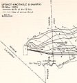 Upshot-knothole-harry-radiation.jpg 607 × 652; 100 KB
-
 UT-34 West, TO I-15 in St. George - panoramio.jpg 1,600 × 1,200; 707 KB
-
 Utah Desert.JPG 7,069 × 4,724; 3.31 MB
-
 UTMap-doton-StGeorge.PNG 238 × 300; 18 KB
-
 View from Old Airport - panoramio.jpg 1,600 × 1,200; 487 KB
-
 VIRGIN RIVER CANYON - panoramio.jpg 1,785 × 1,136; 472 KB
-
 Virgin River Canyon, Utah 5-14a (19401546988).jpg 2,800 × 2,035; 2.53 MB
-
 Virgin River Gorge, St. George, UT 5-14 (24424177511).jpg 2,800 × 1,871; 2.41 MB
-
 Virgin River in St George 1.jpg 2,400 × 1,600; 619 KB
-
 VIRGIN RIVER UTAH - panoramio.jpg 1,785 × 1,136; 503 KB
-
 VIRGIN RIVER UTAH TWO - panoramio.jpg 1,785 × 1,136; 509 KB
-

-
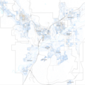
 Washingtoncounty ut.png 980 × 663; 35 KB
-
 Water Fountain at Tabernacle.jpg 1,023 × 685; 106 KB
-

-
 WorldMark St. George.jpg 2,048 × 1,365; 794 KB
-
 Yant Flat Conception Cliffs - Flickr - Bold Frontiers.jpg 1,800 × 1,414; 2.82 MB
-
 美國黃石公園25.jpg 3,008 × 2,000; 1.55 MB
-
 美國黃石公園26.jpg 3,008 × 2,000; 1.54 MB


.jpg)
.jpg)
.jpg)
.jpg)
.jpg)
.jpg)
.jpg)
.jpg)


.jpg)
.jpg)


.jpg)


_-_panoramio.jpg)

.jpg)
.jpg)
.jpg)


.jpg)


.jpg)
.jpg)
.jpg)
.jpg)
.jpg)


.jpg)


.jpg)


.jpg)
.jpg)
.jpg)
.jpg)
.jpg)
.jpg)


.jpg)


.jpg)
.jpg)
.jpg)
.jpg)
.jpg)
.jpg)
.jpg)

.jpg)


.jpg)
.jpg)


.jpg)
.jpg)
Categories:
- Cities in Utah
- Populated places in Washington County, Utah
- County seats in Utah
- University and college towns in the United States
- Big Valley (Arizona-Utah)
- Populated places in the United States named after people
- Cities coinciding a state border within the United States
- Locations along Interstate 15 in Washington County, Utah
- Locations along U.S. Route 91 in Utah (1926-1974) in Washington County, Utah
- Locations along Utah State Route 7
- Locations along Utah State Route 18 in Washington County, Utah
- Locations along Utah State Route 64 (1931-1969)