Category:St. Jakobus (Laaber)
Jump to navigation
Jump to search
| Object location | | View all coordinates using: OpenStreetMap |
|---|
.JPG)  | |||||
| Upload media | |||||
| Instance of | |||||
|---|---|---|---|---|---|
| Named after | |||||
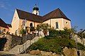
| Location | Laaber, Regensburg, Upper Palatinate, Bavaria, Germany | ||||
| Street address |
| ||||
| Has part(s) |
| ||||
| Heritage designation | |||||
 | |||||
This is the category of the Bavarian Baudenkmal (cultural heritage monument) with the ID D-3-75-162-19 (Wikidata)
|
Subcategories
This category has the following 2 subcategories, out of 2 total.
Media in category "St. Jakobus (Laaber)"
The following 13 files are in this category, out of 13 total.
-
 Kreuzaltar in der Pfarrkirche St. Jakobus (Laaber).JPG 2,448 × 3,264; 3.3 MB
-
 Laaber (Pfarrkirche St. Jakobus-1).jpg 2,560 × 1,920; 807 KB
-
 Laaber - panoramio - Hans100 (1).jpg 5,456 × 3,632; 5.69 MB
-
 Laaber - panoramio - Hans100 (2).jpg 5,456 × 3,632; 4.41 MB
-
 Laaber - panoramio - Hans100.jpg 4,812 × 3,211; 4.88 MB
-
 Laaber von oben12.JPG 1,567 × 1,212; 626 KB
-
 Orgelempore in der Pfarrkirche St. Jakobus (Laaber).JPG 3,264 × 2,448; 3.36 MB
-
 Pfarrkirche St. Jakobus (Laaber).JPG 3,264 × 2,448; 3.02 MB
-
 Pfarrkirche St. Jakobus Laaber 01.jpg 2,414 × 1,357; 2.57 MB
-
 Pfarrkirche St. Jakobus Laaber 02.jpg 2,486 × 1,398; 2.43 MB
-
 Pfarrkirche St. Jakobus Laaber 03.jpg 2,514 × 1,884; 2.98 MB
-
 Pfarrkirche St. Jakobus Laaber 04.jpg 2,502 × 1,876; 2.91 MB
-
 Pfarrkirche St. Jakobus Laaber 05.jpg 2,592 × 1,458; 2.79 MB
.JPG)
.jpg)
.jpg)
.jpg)


.JPG)


