Category:St. Johann Baptist (Mittelstreu)
Jump to navigation
Jump to search
| Object location | | View all coordinates using: OpenStreetMap |
|---|
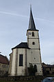
cultural heritage monument D-6-73-151-51 (0) in Oberstreu, Bavaria  | |||||
| Upload media | |||||
| Instance of | |||||
|---|---|---|---|---|---|
| Location | Oberstreu, Rhön-Grabfeld, Lower Franconia, Bavaria, Germany | ||||
| Street address |
| ||||
| Has part(s) |
| ||||
| Heritage designation | |||||
 | |||||
Subcategories
This category has only the following subcategory.
Media in category "St. Johann Baptist (Mittelstreu)"
The following 32 files are in this category, out of 32 total.
-
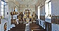
 Innenansicht Sankt Johann Baptist Mittelstreu01102019 1.png 4,980 × 3,320; 31.44 MB
-
 Innenansicht Sankt Johann Baptist Mittelstreu01102019 2.png 5,058 × 3,372; 28.95 MB
-
 KichenTuerMittelstreu.jpg 709 × 945; 92 KB
-
 KircheDenkmalMittelstreu.jpg 945 × 661; 99 KB
-
 KircheEchterMittelstreu.jpg 945 × 709; 147 KB
-
 KircheMittelstreu.jpg 709 × 945; 81 KB
-
 Mittelstreu St. Johannes d.T. 01.jpg 3,528 × 4,000; 1.8 MB
-
 Mittelstreu St. Johannes d.T. 02.jpg 3,648 × 2,736; 2.05 MB
-
 Mittelstreu St. Johannes d.T. 03.jpg 2,736 × 3,448; 1.18 MB
-
 Mittelstreu St. Johannes d.T. 04.jpg 4,636 × 2,736; 2.27 MB
-
 Mittelstreu St. Johannes d.T. 05.jpg 3,648 × 2,704; 1.99 MB
-
 Mittelstreu St. Johannes d.T. 06.jpg 5,670 × 3,000; 3.03 MB
-
 Mittelstreu St. Johannes d.T. 07.jpg 3,648 × 2,736; 2.13 MB
-
 Mittelstreu St. Johannes d.T. 08.jpg 3,648 × 2,600; 1.89 MB
-
 Mittelstreu St. Johannes d.T. 09.jpg 3,648 × 1,656; 1.26 MB
-
 Mittelstreu, Pfarrkirche-001.jpg 3,264 × 4,928; 7.17 MB
-
 Mittelstreu, Pfarrkirche-002.jpg 3,264 × 4,928; 7.28 MB
-
 Mittelstreu, Pfarrkirche-003.jpg 3,264 × 4,928; 8.13 MB
-
 Mittelstreu, Pfarrkirche-005.jpg 3,264 × 4,928; 8.27 MB
-
 Mittelstreu, Pfarrkirche-006.jpg 4,928 × 3,264; 10.88 MB
-
 Mittelstreu, Rathaus-004.jpg 3,264 × 4,928; 8.3 MB
-
 Oberstreu, Mittelstreu, Hauptstraße, Kath. Pfarrkirche, 001.jpg 3,264 × 4,928; 7.38 MB
-
 Oberstreu, Mittelstreu, Hauptstraße, Kath. Pfarrkirche, 002.jpg 3,264 × 4,928; 7.93 MB
-
 Oberstreu, Mittelstreu, Hauptstraße, Kath. Pfarrkirche, 003.jpg 3,264 × 4,928; 7.16 MB
-
 Oberstreu, Mittelstreu, Hauptstraße, Kath. Pfarrkirche, 004.jpg 3,264 × 4,928; 7.76 MB
-
 Oberstreu, Mittelstreu, Hauptstraße, Kath. Pfarrkirche, 005.jpg 4,928 × 3,264; 10.32 MB
-
 Oberstreu, Mittelstreu, Hauptstraße, Kath. Pfarrkirche, 006.jpg 4,928 × 3,264; 9.2 MB
-
 Oberstreu, Mittelstreu, Hauptstraße, Kath. Pfarrkirche, 007.jpg 3,264 × 4,928; 10.23 MB
-
 Oberstreu, Mittelstreu, Hauptstraße, Kath. Pfarrkirche, 008.jpg 3,264 × 4,928; 10.05 MB
-
 Oberstreu, Mittelstreu, Hauptstraße, Kath. Pfarrkirche, 011.jpg 3,264 × 4,928; 10.16 MB
-
 Oberstreu, Mittelstreu, Hauptstraße, Kath. Pfarrkirche, 012.jpg 4,928 × 3,264; 9.51 MB
-
 Sankt Johann Baptist Mittelstreu01102019.png 3,372 × 5,058; 22.36 MB


