Category:St. Josef (Steckelsdorf)
Jump to navigation
Jump to search
| Object location | | View all coordinates using: OpenStreetMap |
|---|
church building in Brandenburg state, Germany  | |||||
| Upload media | |||||
| Instance of | |||||
|---|---|---|---|---|---|
| Named after | |||||
| Location | Steckelsdorf, Rathenow, Havelland District, Brandenburg, Germany | ||||
 | |||||
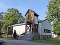
English: Catholic St.Joseph church in Steckelsdorf, Rathenow municipality, Havelland district, Brandenburg state, Germany
Deutsch: Katholische St.Josef-Kirche in Steckelsdorf, Stadt Rathenow, Landkreis Havelland, Land Brandenburg, Deutschland.
Français : Église catholique St.Joseph à Steckelsdorf, ville de Rathenow, arrondissement Pays de la Havel, état fédéral de Brandebourg, Allemagne
Subcategories
This category has only the following subcategory.
I
Media in category "St. Josef (Steckelsdorf)"
The following 6 files are in this category, out of 6 total.
-
 Steckelsdorf Josef 1.jpg 4,896 × 3,672; 2.2 MB
-
 Steckelsdorf Josef 2.jpg 4,896 × 3,672; 1.98 MB
-
 Steckelsdorf Josef 4.jpg 4,896 × 3,672; 2.41 MB
-
 Steckelsdorf Josef 5.jpg 4,896 × 3,672; 1.88 MB
-
 Steckelsdorf Josef 6.jpg 4,896 × 3,672; 3.36 MB
-
 Steckelsorf Josef 3.jpg 3,672 × 4,896; 2.1 MB


