Category:St. Louis County, Minnesota
Zur Navigation springen
Zur Suche springen
Counties of Minnesota: Aitkin · Anoka · Becker · Beltrami · Benton · Big Stone · Blue Earth · Brown · Carlton · Carver · Cass · Chippewa · Chisago · Clay · Clearwater · Cook · Cottonwood · Crow Wing · Dakota · Dodge · Douglas · Faribault · Fillmore · Freeborn · Goodhue · Grant · Hennepin · Houston · Hubbard · Isanti · Itasca · Jackson · Kanabec · Kandiyohi · Kittson · Koochiching · Lac qui Parle · Lake · Lake of the Woods · Le Sueur · Lincoln · Lyon · Mahnomen · Marshall · Martin · McLeod · Meeker · Mille Lacs · Morrison · Mower · Murray · Nicollet · Nobles · Norman · Olmsted · Otter Tail · Pennington · Pine · Pipestone · Polk · Pope · Ramsey · Red Lake · Redwood · Renville · Rice · Rock · Roseau · St. Louis · Scott · Sherburne · Sibley · Stearns · Steele · Stevens · Swift · Todd · Traverse · Wabasha · Wadena · Waseca · Washington · Watonwan · Wilkin · Winona · Wright · Yellow Medicine
English: St. Louis County is a county located in the U.S. state of Minnesota. As of the 2010 census, the population was 200,226. Its county seat is Duluth. It is the largest county by total area in Minnesota, and the second largest in the United States east of the Mississippi River; in land area alone, after Aroostook County, Maine. Major industries include pulpwood production and tourism. Surface mining of high-grade iron-ore remains an important part of the economy of the Iron Range. Parts of the Bois Forte and Fond du Lac Indian reservations are in the county.
County im US-Bundesstaat Minnesota   | |||||
| Medium hochladen | |||||
| Ist ein(e) | |||||
|---|---|---|---|---|---|
| Benannt nach | |||||
| Ort | Minnesota | ||||
| Hauptstadt | |||||
| Datum der Gründung, Erstellung, Entstehung, Erbauung |
| ||||
| Einwohnerzahl |
| ||||
| Fläche |
| ||||
| Verschieden von | |||||
| offizielle Website | |||||
 | |||||
Unterkategorien
Es werden 11 von insgesamt 11 Unterkategorien in dieser Kategorie angezeigt:
In Klammern die Anzahl der enthaltenen Kategorien (K), Seiten (S), Dateien (D)
G
H
N
P
T
Medien in der Kategorie „St. Louis County, Minnesota“
Folgende 19 Dateien sind in dieser Kategorie, von 19 insgesamt.
-
 1920 map Minnesota - west central St Louis County.png 751 × 455; 758 KB
-
 A nice bass - 19823202564.jpg 4.016 × 6.016; 9,73 MB
-
 Bengal, Minnesota plat map, 1914.png 612 × 620; 117 KB
-
 BridgeNoL6007.jpg 320 × 214; 92 KB
-
De-St. Louis.ogg 1,9 s; 18 KB
-
 DSSA RS-1 (cropped).jpg 452 × 253; 141 KB
-
 Eldes Corner (2685594190).jpg 2.592 × 2.592; 2,45 MB
-
 Fig 2 map of St Louis River drainage basin.jpg 1.049 × 750; 110 KB
-
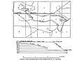 Fig 3 Map and profile of canal of Great Northern Power Co.jpg 1.016 × 738; 82 KB
-
 Hdr capture golf swing ghost effect.jpg 1.632 × 1.224; 899 KB
-
-
-
 Mesabi Miner Cargo Ship in Lake Superior - Minnesota (43981918974).jpg 5.108 × 3.152; 8,69 MB
-
 Minnesota Sunset - 20452075961.jpg 5.898 × 1.872; 7,44 MB
-
 Rocks - panoramio (11).jpg 4.288 × 3.216; 3,78 MB
-
 Rooster Gate - panoramio.jpg 3.264 × 2.448; 3,96 MB
-
 Sleds for the ice sliding in Palo, Minnesota.jpg 8.640 × 5.760; 37,34 MB
-
 USA St. Louis County, Minnesota age pyramid.svg 520 × 600; 7 KB
-
 Woman and kids ice sliding in Palo, Minnesota.jpg 5.726 × 3.817; 9,76 MB


.jpg)
.jpg)


_(weathered_zone_in_the_Biwabik_Iron-Formation,_Whiteside_Mine,_Buhl,_Minnesota.jpg)

.jpg)
.jpg)


