Category:St. Louis County, Minnesota
Jump to navigation
Jump to search
Counties of Minnesota: Aitkin · Anoka · Becker · Beltrami · Benton · Big Stone · Blue Earth · Brown · Carlton · Carver · Cass · Chippewa · Chisago · Clay · Clearwater · Cook · Cottonwood · Crow Wing · Dakota · Dodge · Douglas · Faribault · Fillmore · Freeborn · Goodhue · Grant · Hennepin · Houston · Hubbard · Isanti · Itasca · Jackson · Kanabec · Kandiyohi · Kittson · Koochiching · Lac qui Parle · Lake · Lake of the Woods · Le Sueur · Lincoln · Lyon · Mahnomen · Marshall · Martin · McLeod · Meeker · Mille Lacs · Morrison · Mower · Murray · Nicollet · Nobles · Norman · Olmsted · Otter Tail · Pennington · Pine · Pipestone · Polk · Pope · Ramsey · Red Lake · Redwood · Renville · Rice · Rock · Roseau · St. Louis · Scott · Sherburne · Sibley · Stearns · Steele · Stevens · Swift · Todd · Traverse · Wabasha · Wadena · Waseca · Washington · Watonwan · Wilkin · Winona · Wright · Yellow Medicine
English: St. Louis County is a county located in the U.S. state of Minnesota. As of the 2010 census, the population was 200,226. Its county seat is Duluth. It is the largest county by total area in Minnesota, and the second largest in the United States east of the Mississippi River; in land area alone, after Aroostook County, Maine. Major industries include pulpwood production and tourism. Surface mining of high-grade iron-ore remains an important part of the economy of the Iron Range. Parts of the Bois Forte and Fond du Lac Indian reservations are in the county.
county in Minnesota, United States   | |||||
| Upload media | |||||
| Instance of | |||||
|---|---|---|---|---|---|
| Named after | |||||
| Location | Minnesota | ||||
| Capital | |||||
| Inception |
| ||||
| Population |
| ||||
| Area |
| ||||
| Different from | |||||
| official website | |||||
 | |||||
Subcategories
This category has the following 11 subcategories, out of 11 total.
H
N
P
Media in category "St. Louis County, Minnesota"
The following 63 files are in this category, out of 63 total.
-
 1920 map Minnesota - west central St Louis County.png 751 × 455; 758 KB
-
 A nice bass - 19823202564.jpg 4,016 × 6,016; 9.73 MB
-
 Aqua garage in Kinney, Minnesota.jpg 8,640 × 5,760; 27.94 MB
-
 Bengal, Minnesota plat map, 1914.png 612 × 620; 117 KB
-
 BridgeNoL6007.jpg 320 × 214; 92 KB
-
 Brookston City Hall.jpg 7,756 × 5,171; 24.63 MB
-
 Buhl Abundant Water, Land & Good People sign in Buhl, Minnesota.jpg 8,688 × 5,792; 32.29 MB
-
De-St. Louis.ogg 1.9 s; 18 KB
-
 DM&IR 332, Little Sucker River Bridge.jpg 1,920 × 1,289; 1.64 MB
-
 DSSA RS-1 (cropped).jpg 452 × 253; 141 KB
-
 Eldes Corner (2685594190).jpg 2,592 × 2,592; 2.45 MB
-

-
 Fig 2 map of St Louis River drainage basin.jpg 1,049 × 750; 110 KB
-
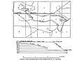 Fig 3 Map and profile of canal of Great Northern Power Co.jpg 1,016 × 738; 82 KB
-
 Green garage in Buhl, Minnesota.jpg 8,688 × 5,792; 26.74 MB
-
 Haunted House - panoramio.jpg 2,102 × 1,864; 1.97 MB
-
 Hdr capture golf swing ghost effect.jpg 1,632 × 1,224; 899 KB
-
-
 Highway 133 in Winter - Minnesota (33524210918).jpg 7,893 × 5,265; 19.69 MB
-
-
 Lake Vermilion Dock, Northern Minnesota - Everetts Bay (44431930032).jpg 5,612 × 3,799; 13.06 MB
-
 Laurentian Divide HW 53 St Louis county MN IMG 1482 Virginia-Tower.JPG 3,659 × 2,359; 2.04 MB
-
 Lester River, Duluth 7 4 21 (51297141234).jpg 4,000 × 5,600; 24.06 MB
-
 Little Sucker River.jpg 2,046 × 1,536; 943 KB
-
 Lodge (121526501).jpeg 2,048 × 1,365; 1.04 MB
-
 McDavitt Township, Minnesota Sign (45813420814).jpg 7,774 × 5,185; 19.15 MB
-
 Meadowlands Community Center in Meadowlands, Minnesota.jpg 8,688 × 5,792; 23.32 MB
-
 Mesabi Miner Cargo Ship in Lake Superior - Minnesota (43981918974).jpg 5,108 × 3,152; 8.69 MB
-
 Minnesota - Birch Lake - NARA - 23941591.jpg 4,385 × 3,382; 3.3 MB
-
 Minnesota - Birch Lake - NARA - 23941593.jpg 4,385 × 3,382; 3.08 MB
-
 Minnesota Sunset - 20452075961.jpg 5,898 × 1,872; 7.44 MB
-
 MN St Louis County 190720094985pelican river.jpg 2,592 × 1,774; 1.09 MB
-
 MN St Louis County north 210720095019ind res hospital.jpg 2,592 × 1,399; 588 KB
-
 Nelimark Homestead Museum.jpg 3,160 × 1,540; 4.05 MB
-
 Otter falls. - panoramio.jpg 1,215 × 1,800; 1.03 MB
-
 Pike River.jpg 3,067 × 2,301; 4.26 MB
-
 Portage trail from cummings to neewin. 70 rods - panoramio.jpg 1,800 × 1,215; 1.55 MB
-
 Rocks - panoramio (11).jpg 4,288 × 3,216; 3.78 MB
-
 Rooster Gate - panoramio.jpg 3,264 × 2,448; 3.96 MB
-
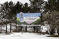
 Sax-Zim Bog Welcome Center sign in Meadowlands, Minnesota.jpg 8,149 × 5,433; 18.69 MB
-
 Shield P7170061.jpg 3,072 × 2,304; 1.55 MB
-
 Shield P7170062.jpg 3,072 × 2,304; 1.4 MB
-
 Shield P7170063.jpg 3,072 × 2,304; 1.43 MB
-
 Shield P7170066.jpg 3,072 × 2,304; 1.58 MB
-
 Sleds for the ice sliding in Palo, Minnesota.jpg 8,640 × 5,760; 37.34 MB
-
 Soudan Baptist Church Minnesota (35409183304).jpg 5,395 × 3,597; 14.62 MB
-
 Soudan Underground Mine State Park - Sign (37592702056).jpg 4,605 × 3,103; 10.48 MB
-
 St Louis co hwy 135 embarrass southwards IMG 1489.JPG 3,077 × 2,143; 1.61 MB
-
 St Louis co hwy 135 southwards embarrass IMG 1493.JPG 3,343 × 2,220; 1.59 MB
-
 St Louis co hwy 4 Vermillion Trail southwards IMG 1507.JPG 3,417 × 2,348; 1.87 MB
-
 Start of portage trail to Neewin lake, on the Cummings lake side - panoramio.jpg 1,800 × 1,215; 1.75 MB
-
 Sturgeon River of St Louis County MN.JPG 1,280 × 896; 204 KB
-
 Sunset, looking west from site on cummings. 2008 - panoramio.jpg 1,800 × 1,215; 1.39 MB
-
 The ice slide at Laskiainen in Palo, Minnesota.jpg 6,382 × 4,255; 17.05 MB
-
 Town of Great Scott Town Hall in St. Louis County, Minnesota.jpg 8,640 × 5,760; 30.35 MB
-
 Trip Up North (8963626255).jpg 4,608 × 3,456; 3.81 MB
-
 Trip Up North (8964820140).jpg 4,608 × 3,456; 6.09 MB
-
 United States Post Office in Iron, Minnesota.jpg 7,764 × 5,176; 27.15 MB
-
 USA St. Louis County, Minnesota age pyramid.svg 520 × 600; 7 KB
-
 Welcome to Elmer Township sign in Saint Louis County, Minnesota.jpg 8,688 × 5,792; 28.28 MB
-
 Welcome to Meadowlands sign in Saint Louis County, Minnesota.jpg 8,688 × 5,792; 26.64 MB
-
 Woman and kids ice sliding in Palo, Minnesota.jpg 5,726 × 3,817; 9.76 MB
-
 Zim Post Office in Zim, Minnesota.jpg 8,688 × 5,792; 34.25 MB


.jpg)
.jpg)
.jpg)


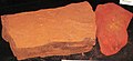
_(weathered_zone_in_the_Biwabik_Iron-Formation,_Whiteside_Mine,_Buhl,_Minnesota.jpg)
.jpg)

.jpg)

.jpg)

.jpeg)
.jpg)

.jpg)


.jpg)


.jpg)
.jpg)


.jpg)
.jpg)


