Category:St. Marienkirche (Trebbin)
Jump to navigation
Jump to search
| Object location | | View all coordinates using: OpenStreetMap |
|---|
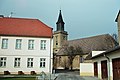
church building in Trebbin, Germany  | |||||
| Upload media | |||||
| Instance of | |||||
|---|---|---|---|---|---|
| Named after | |||||
| Location | Trebbin, Teltow-Fläming District, Brandenburg, Germany | ||||
| Architectural style | |||||
| Heritage designation | |||||
 | |||||
This is the category of the Brandenburger Baudenkmal (cultural heritage monument) with the ID 09105518 (Wikidata)
|
Deutsch: Die Stadtkirche St. Marien in Trebbin in Brandenburg wurde 1740 bis 1744 erbaut. Die Kirche steht unter Denkmalschutz.
Media in category "St. Marienkirche (Trebbin)"
The following 13 files are in this category, out of 13 total.
-
 Stadtkirche St. Marien Trebbin.jpg 3,024 × 4,032; 3.95 MB
-

-

-
 Trebbin St Marien Kirche aussen 2013.jpg 4,928 × 3,264; 9.88 MB
-
 Trebbin St Marien Kirche Aussen.jpg 3,872 × 2,592; 1.11 MB
-
 Trebbin St. Marien Altar.jpg 3,456 × 4,608; 4.15 MB
-
 Trebbin St. Marien Chor.JPG 2,592 × 1,944; 1.91 MB
-
 Trebbin St. Marien Eingangsportal.JPG 2,592 × 1,944; 1.86 MB
-
 Trebbin St. Marien Epitaph Nordseite.JPG 1,944 × 2,592; 1.82 MB
-
 Trebbin St. Marien Schuke-Orgel.jpg 4,608 × 3,456; 4.41 MB
-
 Trebbin St. Marien Turm.JPG 1,944 × 2,592; 1.27 MB
-
 Trebbin St. Marien.JPG 2,592 × 1,944; 2.16 MB
-
 Trebbin, die Kirche St. Marien.jpg 2,551 × 1,701; 1.11 MB

_-_geo.hlipp.de_-_38136.jpg)
_-_geo.hlipp.de_-_38137.jpg)


