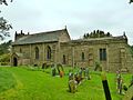
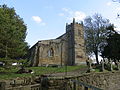
Category:St Lawrence's church, Kirby Sigston
Jump to navigation
Jump to search
| Object location | | View all coordinates using: OpenStreetMap |
|---|
church in Kirby Sigston, North Yorkshire, England, UK  | |||||
| Upload media | |||||
| Instance of | |||||
|---|---|---|---|---|---|
| Dedicated to | |||||
| Location | Kirby Sigston, Hambleton, North Yorkshire, Yorkshire and the Humber, England | ||||
| Diocese | |||||
| Heritage designation |
| ||||
| Inception |
| ||||
| Religion or worldview | |||||
 | |||||
Media in category "St Lawrence's church, Kirby Sigston"
The following 3 files are in this category, out of 3 total.
-
 St Lawrence Church, Kirby Sigston (geograph 2028080).jpg 1,280 × 960; 435 KB
-
 St Lawrence Church, Kirby Sigston.jpg 550 × 412; 75 KB
-
 St Lawrences Church at Kirby Sigston (geograph 4209705).jpg 4,000 × 3,000; 3.14 MB
.jpg)
.jpg)
Categories:
- Grade I listed buildings in Hambleton District
- Kirby Sigston
- Grade I listed churches in North Yorkshire
- Saint Lawrence churches in North Yorkshire
- Pseudobasilicas in North Yorkshire
- 12th-century churches in North Yorkshire
- 13th-century churches in North Yorkshire
- 18th-century church towers in North Yorkshire