Category:Stadtkirche Greiffenberg
Jump to navigation
Jump to search
| Object location | | View all coordinates using: OpenStreetMap |
|---|
church building in Brandenburg state, Germany _2018_SW.jpg) | |||||
| Upload media | |||||
| Instance of | |||||
|---|---|---|---|---|---|
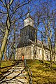
| Location | Greiffenberg (Uckermark), Angermünde, Uckermark District, Brandenburg, Germany | ||||
| Heritage designation | |||||
 | |||||
This is the category of the Brandenburger Baudenkmal (cultural heritage monument) with the ID 09130472 (Wikidata)
|
English: Church in Greiffenberg, Angermünde municipality, Uckermark district, Brandenburg state, Germany
Deutsch: Kirche in Greiffenberg, Stadt Angermünde, Landkreis Uckermark, Land Brandenburg, Deutschland.
Français : Église de Greiffenberg, ville de Angermünde, arrondissement Uckermark, état fédéral de Brandebourg, Allemagne
Media in category "Stadtkirche Greiffenberg"
The following 8 files are in this category, out of 8 total.
-
 12-12-26-greiffenberg-by-RalfR-01.jpg 2,848 × 4,288; 6.57 MB
-
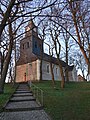
 Dorfkirche Greiffenberg (Uckermark) 2018 NW.jpg 4,976 × 4,700; 10.73 MB
-
 Dorfkirche Greiffenberg (Uckermark) 2018 SE.jpg 5,594 × 4,938; 11.47 MB
-
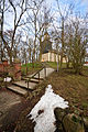
 Dorfkirche Greiffenberg (Uckermark) 2018 SW.jpg 3,648 × 4,864; 7.59 MB
-
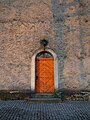
 Dorfkirche Greiffenberg (Uckermark) 2018 Südportal.jpg 3,648 × 4,864; 4.57 MB
-
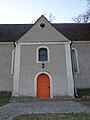
 Dorfkirche Greiffenberg (Uckermark) 2018 Westportal.jpg 3,648 × 4,864; 5.54 MB
-
 Greiffenberg03 11 05 jiw.jpg 2,000 × 3,000; 2.65 MB
-
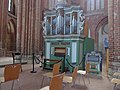 Interior of Marienkirche (Prenzlau) 03.jpg 4,608 × 3,456; 6.33 MB

_2018_NW.jpg)
_2018_SE.jpg)
_2018_S%C3%BCdportal.jpg)
_2018_Westportal.jpg)

_03.jpg)