Category:Stathern
Jump to navigation
Jump to search
village and civil parish in Melton, Leicestershire, England | |||||
| Upload media | |||||
| Instance of | |||||
|---|---|---|---|---|---|
| Location | Melton, Leicestershire, East Midlands, England | ||||
 | |||||
Subcategories
This category has the following 4 subcategories, out of 4 total.
Media in category "Stathern"
The following 200 files are in this category, out of 276 total.
(previous page) (next page)-
 'The Willows', Harby Lane - geograph.org.uk - 5922743.jpg 1,024 × 683; 183 KB
-
 'Vale View', Blacksmith End - geograph.org.uk - 5922700.jpg 1,024 × 683; 174 KB
-

-
 Ashleigh, Main Street, Stathern - geograph.org.uk - 5717325.jpg 1,280 × 960; 342 KB
-
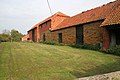 Barns on Harby Lane, Stathern - geograph.org.uk - 592445.jpg 640 × 427; 95 KB
-
 Bench mark, Harby Lane railway bridge, Plungar - geograph.org.uk - 5169212.jpg 995 × 1,280; 582 KB
-
 Bench mark, Harby Lane railway bridge, Stathern - geograph.org.uk - 5169059.jpg 918 × 1,280; 458 KB
-
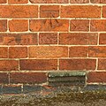
 Bench mark, Harby Lane, Stathern - geograph.org.uk - 5717186.jpg 1,280 × 1,280; 663 KB
-
 Bench mark, Main Street, Stathern - geograph.org.uk - 5717328.jpg 1,280 × 1,280; 552 KB
-
 Benchmark on ^1 Harby Lane - geograph.org.uk - 5922733.jpg 1,024 × 677; 306 KB
-
 Benchmark on ^27 Main Street - geograph.org.uk - 5922483.jpg 1,024 × 662; 240 KB
-
 Between road and abandoned railway - geograph.org.uk - 2793326.jpg 1,024 × 768; 300 KB
-
 Blacksmith End away from Stathern - geograph.org.uk - 5179082.jpg 640 × 484; 110 KB
-
 Blacksmith End towards Stathern - geograph.org.uk - 5179059.jpg 640 × 482; 107 KB
-
 Bridge 46 - geograph.org.uk - 3552502.jpg 640 × 432; 138 KB
-
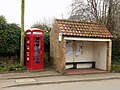 Bus shelter and K6 telephone kiosk - geograph.org.uk - 5717338.jpg 1,280 × 960; 420 KB
-
 Butchers shop, Stathern - geograph.org.uk - 5717318.jpg 1,280 × 960; 301 KB
-
 Canal Lane - geograph.org.uk - 2793320.jpg 1,024 × 768; 113 KB
-
 Canal Lane - geograph.org.uk - 3574657.jpg 640 × 480; 90 KB
-
 Canal Lane - geograph.org.uk - 3574666.jpg 640 × 480; 74 KB
-

-
 Canal towpath - geograph.org.uk - 941427.jpg 640 × 427; 85 KB
-

-
 Cemetery, Stathern - geograph.org.uk - 1192297.jpg 640 × 480; 72 KB
-
 Chantry Cottage, Stathern - geograph.org.uk - 3235382.jpg 1,024 × 768; 178 KB
-
 Church Cottage, Stathern - geograph.org.uk - 5717253.jpg 1,280 × 960; 413 KB
-
 Church Lane in Stathern - geograph.org.uk - 2025144.jpg 2,914 × 2,226; 2.95 MB
-
 Church Lane in Stathern - geograph.org.uk - 2025178.jpg 3,167 × 1,982; 2.7 MB
-
 Church Lane in Stathern - geograph.org.uk - 2025244.jpg 2,690 × 2,031; 2.37 MB
-
 Churchyard and Old Rectory, Stathern - geograph.org.uk - 3235318.jpg 1,024 × 768; 241 KB
-
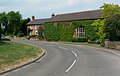
 Coming into Stathern (1) - geograph.org.uk - 5470561.jpg 640 × 480; 192 KB
-
 Coming into Stathern (2) - geograph.org.uk - 5470633.jpg 640 × 480; 139 KB
-
 Cottages by the railway - geograph.org.uk - 2793331.jpg 1,024 × 768; 125 KB
-
 Cottages, Church Lane, Stathern (2) - geograph.org.uk - 3235301.jpg 1,024 × 768; 153 KB
-
 Cottages, Church Lane, Stathern - geograph.org.uk - 3235294.jpg 1,024 × 768; 142 KB
-
 Crop field, Stathern Bridge - geograph.org.uk - 3574663.jpg 640 × 480; 68 KB
-
 Crossroads, Stathern, with signs - geograph.org.uk - 1192314.jpg 640 × 480; 96 KB
-
 Dead end footpath - geograph.org.uk - 5717273.jpg 960 × 1,280; 498 KB
-

-
 Descending Mill Hill towards Stathern - geograph.org.uk - 2025424.jpg 2,652 × 1,852; 2.16 MB
-
 Dilapidated barn, from Toft's Lane - geograph.org.uk - 1192290.jpg 640 × 480; 122 KB
-
 Distance marker - geograph.org.uk - 941454.jpg 427 × 640; 120 KB
-

-
 Don't enter here^ (2) - geograph.org.uk - 614125.jpg 640 × 480; 115 KB
-
 Dove Cottage - geograph.org.uk - 3552495.jpg 640 × 427; 78 KB
-
 Driveway to buildings at White House - geograph.org.uk - 5018241.jpg 640 × 481; 134 KB
-

-
 Eastbury, Penn Lane, Stathern - geograph.org.uk - 5729410.jpg 1,280 × 960; 412 KB
-
 Edward VII letterbox, Stathern - geograph.org.uk - 592677.jpg 427 × 640; 111 KB
-
 End of a day's walking - geograph.org.uk - 1192305.jpg 640 × 480; 82 KB
-
 Engineering works, Stathern - geograph.org.uk - 1192135.jpg 640 × 480; 68 KB
-

-
 Entrance to field east of Blacksmith End - geograph.org.uk - 5179060.jpg 640 × 474; 115 KB
-
 Entrance to field north of Long Lane - geograph.org.uk - 5018248.jpg 640 × 418; 77 KB
-
 Farm track beside dismantled railway - geograph.org.uk - 3574667.jpg 640 × 480; 100 KB
-
 Farm track near Stathern - geograph.org.uk - 2025286.jpg 1,984 × 1,329; 1 MB
-
 Farmland beneath a brooding sky - geograph.org.uk - 6173524.jpg 640 × 480; 78 KB
-

-
 Farmland southwest of Stathern - geograph.org.uk - 2025319.jpg 2,318 × 1,680; 1.61 MB
-
 Farmland southwest of Stathern - geograph.org.uk - 2025357.jpg 2,761 × 1,993; 2.34 MB
-

-

-

-
 Field at the back of Canal Cottage - geograph.org.uk - 1013160.jpg 640 × 480; 108 KB
-
 Field near to Baileys Farm - geograph.org.uk - 5179045.jpg 640 × 460; 84 KB
-

-
 Field of maize - geograph.org.uk - 1013129.jpg 640 × 480; 102 KB
-
 Field path through oil seed rape, N of Stathern - geograph.org.uk - 6006571.jpg 5,184 × 2,920; 6.09 MB
-
 Field track off Toft's Lane - geograph.org.uk - 5470314.jpg 480 × 640; 256 KB
-
 Field west of Blacksmith End - geograph.org.uk - 5179086.jpg 640 × 485; 77 KB
-

-
 Fieldside track - geograph.org.uk - 5179046.jpg 640 × 468; 97 KB
-

-
 Footpath marker post in Stathern Wood - geograph.org.uk - 5469546.jpg 480 × 640; 184 KB
-
 Footpath south of Combs Plantation, nr Stathern - geograph.org.uk - 2643037.jpg 3,024 × 4,032; 6.48 MB
-
 Footpath through Plungar Wood - geograph.org.uk - 2024940.jpg 2,016 × 1,401; 1.33 MB
-

-
 Footpath to Long Lane - geograph.org.uk - 2024969.jpg 1,968 × 1,228; 1.01 MB
-
 Footpath to the church - geograph.org.uk - 5717239.jpg 960 × 1,280; 485 KB
-
 Footpath towards Hose - geograph.org.uk - 5717314.jpg 1,280 × 960; 385 KB
-
 Footpath towards woods on Terrace Hills - geograph.org.uk - 5179093.jpg 640 × 486; 121 KB
-
 Former farmhouse, Church Lane, Stathern - geograph.org.uk - 3235336.jpg 1,024 × 768; 162 KB
-
 Former railway bridge, Harby Lane, Plungar - geograph.org.uk - 5169214.jpg 1,280 × 960; 532 KB
-
 Former shop, Stathern - geograph.org.uk - 3235286.jpg 1,024 × 585; 113 KB
-
 Former stables at the Old Rectory, Stathern - geograph.org.uk - 3235360.jpg 1,024 × 768; 136 KB
-
 From the top of Mill Hill - geograph.org.uk - 674062.jpg 640 × 427; 80 KB
-
 Frozen canal - geograph.org.uk - 2791894.jpg 1,024 × 768; 215 KB
-
 Gateway and stile - geograph.org.uk - 5179047.jpg 640 × 476; 104 KB
-
 Glenleigh, Main Street, Stathern - geograph.org.uk - 5717321.jpg 1,280 × 960; 409 KB
-
 Grantham Canal at Stathern Bridge - geograph.org.uk - 5169074.jpg 1,280 × 821; 373 KB
-
 Grantham Canal from Stathern Bridge - geograph.org.uk - 29451.jpg 640 × 480; 99 KB
-
 Grantham Canal milepost - geograph.org.uk - 5169209.jpg 1,280 × 960; 652 KB
-
 Grantham Canal, Stathern Bridge - geograph.org.uk - 3574661.jpg 640 × 480; 77 KB
-
 Grassy track between crop and hedge - geograph.org.uk - 5018249.jpg 640 × 476; 95 KB
-
 Grazing land by Toft's Lane - geograph.org.uk - 5470534.jpg 640 × 480; 171 KB
-
 Green space, Penn Lane, Stathern - geograph.org.uk - 5729411.jpg 1,280 × 960; 517 KB
-
 Harby Lane, Stathern - geograph.org.uk - 5717202.jpg 1,280 × 960; 325 KB
-
 Heading out of Stathern along Penn Lane - geograph.org.uk - 2025080.jpg 2,480 × 1,565; 1.78 MB
-
 Hill View - geograph.org.uk - 5179052.jpg 640 × 460; 129 KB
-
 Houses along Mill Hill in Stathern - geograph.org.uk - 2025365.jpg 2,579 × 1,619; 1.63 MB
-
 In Plungar Wood - geograph.org.uk - 156760.jpg 640 × 427; 212 KB
-
 In Stathern Wood - geograph.org.uk - 156756.jpg 640 × 427; 221 KB
-
 Ivy House, Church Lane, Stathern - geograph.org.uk - 5210520.jpg 1,280 × 960; 495 KB
-
 Jubilee Way in Stathern Wood - geograph.org.uk - 3228880.jpg 1,024 × 768; 202 KB
-

-
 Late afternoon sunshine over the Vale of Belvoir - geograph.org.uk - 5209984.jpg 1,280 × 857; 383 KB
-
 Llamas in Stathern - geograph.org.uk - 228193.jpg 640 × 480; 74 KB
-
 Long Lane towards Bottesford - geograph.org.uk - 5018251.jpg 640 × 483; 67 KB
-
 Long Lane towards Harby - geograph.org.uk - 5018252.jpg 640 × 471; 72 KB
-
 Long Lane-Moor Lane junction - geograph.org.uk - 5018250.jpg 640 × 502; 112 KB
-
 Long Lane-Penn Lane junction - geograph.org.uk - 5018244.jpg 640 × 465; 69 KB
-

-
 Looking up Toft's Hill, Stathern - geograph.org.uk - 5470828.jpg 640 × 480; 172 KB
-
 Low arch bridge Stathern Road near Harby - geograph.org.uk - 2230028.jpg 1,024 × 761; 127 KB
-
 Main Street into Stathern - geograph.org.uk - 5179053.jpg 640 × 410; 90 KB
-
 Main Street, Stathern - geograph.org.uk - 592055.jpg 640 × 427; 78 KB
-
 Mill Hill in Stathern - geograph.org.uk - 2025272.jpg 2,733 × 1,763; 2.1 MB
-
 Mill Hill near Stathern - geograph.org.uk - 2025416.jpg 2,381 × 1,734; 1.67 MB
-
 Mill Hill towards Eastwell - geograph.org.uk - 5179054.jpg 640 × 406; 72 KB
-
 Mill Hill towards the village of Stathern - geograph.org.uk - 2025374.jpg 2,657 × 1,655; 1.87 MB
-
 Moor Lane near Stathern - geograph.org.uk - 982815.jpg 640 × 490; 72 KB
-
 Needs attention - geograph.org.uk - 1192128.jpg 640 × 480; 70 KB
-
 Nos. 1 ^ 3 Church Lane, Stathern - geograph.org.uk - 5717256.jpg 1,280 × 1,072; 385 KB
-
 Notice on gate to White House buildings - geograph.org.uk - 5018245.jpg 640 × 558; 141 KB
-
 Old railway bridge, near Plungar - geograph.org.uk - 66642.jpg 640 × 480; 140 KB
-
 On Jubilee Way above Stathern Wood, Leics - geograph.org.uk - 6006516.jpg 5,184 × 2,920; 6.48 MB
-
 Open path through Stathern Wood - geograph.org.uk - 2024929.jpg 2,448 × 3,264; 3.17 MB
-
 Out of the wood - geograph.org.uk - 5470440.jpg 640 × 480; 264 KB
-
 Pasture Lane, Stathern - geograph.org.uk - 3228848.jpg 1,024 × 768; 159 KB
-
 Path from cemetery onto Tofts Hill - geograph.org.uk - 5922625.jpg 1,024 × 683; 270 KB
-
 Path into Stathern - geograph.org.uk - 5179048.jpg 640 × 464; 126 KB
-
 Path towards Hose - geograph.org.uk - 5179049.jpg 640 × 479; 93 KB
-
 Penn Lane heading towards Stathern - geograph.org.uk - 2025064.jpg 2,406 × 1,385; 1.4 MB
-
 Penn Lane in the village of Stathern - geograph.org.uk - 2025084.jpg 1,927 × 1,446; 1.18 MB
-
 Penn Lane towards Stathern - geograph.org.uk - 5018246.jpg 640 × 472; 64 KB
-
 Penn Lane, Stathern - geograph.org.uk - 5717184.jpg 1,280 × 960; 459 KB
-
 Pillbox on Mill Hill, Stathern - geograph.org.uk - 828851.jpg 640 × 480; 137 KB
-
 Point Farmhouse, Stathern - geograph.org.uk - 5717214.jpg 1,280 × 983; 358 KB
-
 Pole furniture AT0003 - geograph.org.uk - 5179080.jpg 640 × 435; 27 KB
-
 Pond on a misty morning - geograph.org.uk - 1192147.jpg 640 × 480; 50 KB
-
 Public footpath to Plungar Wood - geograph.org.uk - 2025016.jpg 2,695 × 1,952; 2.47 MB
-
 Pylons from Long Lane - geograph.org.uk - 2230030.jpg 1,024 × 768; 85 KB
-
 Quoins at 3 Church Lane, Stathern - geograph.org.uk - 5717262.jpg 960 × 1,280; 483 KB
-
 Railway bridge, Stathern Road - geograph.org.uk - 5169063.jpg 1,280 × 915; 469 KB
-
 Red Lion Street.jpg 4,467 × 3,456; 5.26 MB
-
 Road sign at Washdyke Farm, Stathern - geograph.org.uk - 29445.jpg 480 × 640; 119 KB
-
 Road to Station Farm, Stathern - geograph.org.uk - 5169065.jpg 1,280 × 960; 534 KB
-
 Seat on Blacksmith End - geograph.org.uk - 5179087.jpg 640 × 472; 172 KB
-

-
 Signpost at Long Lane-Penn Lane junction - geograph.org.uk - 5018247.jpg 640 × 505; 114 KB
-

-
 Small mixed woodland near Stathern - geograph.org.uk - 5470429.jpg 480 × 640; 250 KB
-
 Small mixed woodland, Vale of Belvoir - geograph.org.uk - 5470387.jpg 480 × 640; 241 KB
-
 Small woodland, Vale of Belvoir - geograph.org.uk - 5470398.jpg 640 × 480; 258 KB
-
 Spruce tree on Stathern Road - geograph.org.uk - 2791881.jpg 1,024 × 768; 159 KB
-
 St Guthlac's Church - geograph.org.uk - 5922589.jpg 1,024 × 683; 292 KB
-
 Starlings on the wire - geograph.org.uk - 592408.jpg 640 × 427; 72 KB
-
 Stathern Bridge (no.45), Grantham Canal - geograph.org.uk - 5169206.jpg 1,280 × 872; 438 KB
-
 Stathern Bridge - geograph.org.uk - 2793317.jpg 1,024 × 768; 179 KB
-
 Stathern Bridge - geograph.org.uk - 941437.jpg 640 × 427; 82 KB
-
 Stathern Bridge - geograph.org.uk - 941438.jpg 640 × 427; 94 KB
-

-
 Stathern Garage - geograph.org.uk - 5717343.jpg 1,280 × 931; 224 KB
-
 Stathern Lodge bridge - geograph.org.uk - 3523773.jpg 640 × 480; 79 KB
-
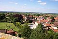 Stathern North.jpg 2,448 × 1,632; 1.2 MB
-
 Stathern Post Office - geograph.org.uk - 2025127.jpg 2,012 × 878; 690 KB
-
 Stathern Primary School - geograph.org.uk - 3235347.jpg 1,024 × 768; 121 KB
-
 Stathern Road - geograph.org.uk - 5169068.jpg 1,280 × 901; 518 KB
-
 Stathern Road towards Stathern - geograph.org.uk - 5179056.jpg 640 × 413; 80 KB
-
 Stathern South.jpg 2,448 × 1,632; 1.19 MB
-
 Stathern War Memorial Institute - geograph.org.uk - 3235279.jpg 1,024 × 769; 158 KB
-
 Stathern Wood - geograph.org.uk - 157166.jpg 427 × 640; 190 KB
-

-

-
 Stathern, Leics - St Guthlac's Church - geograph.org.uk - 6007153.jpg 2,560 × 1,440; 1.46 MB
-
 Station approach - geograph.org.uk - 2793337.jpg 1,024 × 768; 83 KB
-
 Summers Farmhouse, Stathern - geograph.org.uk - 5717182.jpg 1,280 × 960; 440 KB
-
 Summers Farmhouse, Stathern - geograph.org.uk - 5717206.jpg 1,280 × 960; 369 KB
-
 Sunset over the Vale of Belvoir - geograph.org.uk - 2815795.jpg 640 × 480; 56 KB
-
 T-junction at west end of Main Street - geograph.org.uk - 5922708.jpg 683 × 1,024; 197 KB
-
 The end of the street - geograph.org.uk - 5470584.jpg 480 × 640; 195 KB
-
 The former Post Office, Stathern - geograph.org.uk - 5717333.jpg 1,280 × 960; 339 KB
-
 The Grantham Canal - geograph.org.uk - 2793316.jpg 1,024 × 768; 164 KB
-

-
 The Maltings - geograph.org.uk - 5179055.jpg 640 × 430; 102 KB
-

-
 The old grocer's shop, Main Street - geograph.org.uk - 5717234.jpg 1,280 × 978; 306 KB
-
 The Old Rectory, Stathern - geograph.org.uk - 5209990.jpg 1,280 × 960; 431 KB
-
 The Old Rectory, Stathern - geograph.org.uk - 5717209.jpg 1,280 × 960; 481 KB
-
 The Plough in Stathern - geograph.org.uk - 2025112.jpg 2,160 × 1,407; 1.27 MB
-
 The Plough Inn, Stathern - geograph.org.uk - 5717344.jpg 1,280 × 915; 237 KB
-
 The Red Lion, Stathern - geograph.org.uk - 3228841.jpg 1,024 × 768; 112 KB
-
 The Red Lion, Stathern - geograph.org.uk - 64035.jpg 640 × 480; 100 KB
-
 The southern edge of Stathern Wood - geograph.org.uk - 2025413.jpg 3,021 × 1,923; 2.51 MB
-
 Toft's Hill, Stathern - geograph.org.uk - 5470618.jpg 640 × 476; 183 KB
-
 Toft's Hill, Stathern - geograph.org.uk - 5470694.jpg 640 × 491; 166 KB
-
 Toft's Lane, Stathern, Leics - geograph.org.uk - 6006513.jpg 5,184 × 2,920; 6.02 MB
-
 Towards Hill View - geograph.org.uk - 5179057.jpg 640 × 485; 107 KB
-
 Track through the woods northwards - geograph.org.uk - 5179063.jpg 640 × 471; 157 KB
-
 Track through the woods southwards - geograph.org.uk - 5179064.jpg 640 × 475; 164 KB


_-_geograph.org.uk_-_5470561.jpg)
_-_geograph.org.uk_-_5470633.jpg)

_-_geograph.org.uk_-_3235301.jpg)


_-_geograph.org.uk_-_614125.jpg)


,_Grantham_Canal_-_geograph.org.uk_-_5169206.jpg)


