Category:Steinhausstraße 23 (Bunde)
Jump to navigation
Jump to search
| Object location | | View all coordinates using: OpenStreetMap |
|---|
Subcategories
This category has only the following subcategory.
G
Media in category "Steinhausstraße 23 (Bunde)"
The following 8 files are in this category, out of 8 total.
-
 Bunde - Steinhausstraße + 23 - Garten 01 ies.jpg 5,616 × 3,744; 31.42 MB
-
 Bunde - Steinhausstraße - 23 + Garten 01 ies.jpg 5,616 × 3,744; 28.93 MB
-
 Bunde - Steinhausstraße - 23 + Garten 02 ies.jpg 5,616 × 3,744; 30.29 MB
-
 Bunde - Steinhausstraße - 23 + Garten 03 ies.jpg 5,616 × 3,744; 29.79 MB
-
 Bunde - Steinhausstraße - 23 + Garten 04 ies.jpg 5,616 × 3,744; 31.02 MB
-
 Bunde - Steinhausstraße - 23 + Garten 05 ies.jpg 5,616 × 3,744; 28.78 MB
-
 Bunde - Steinhausstraße - 23 + Garten 06 ies.jpg 5,616 × 3,744; 32.73 MB
-
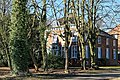
 Bunde - Steinhausstraße - 23 01 ies.jpg 5,616 × 3,743; 25.19 MB


