Category:Steinkreuz Grafenbuch (D-3-73-140-38)
Jump to navigation
Jump to search
| Object location | | View all coordinates using: OpenStreetMap |
|---|
 | |||||
| Upload media | |||||
| Instance of | |||||
|---|---|---|---|---|---|
| Made from material | |||||
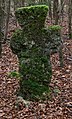
| Location | Lauterhofen, Neumarkt, Upper Palatinate, Bavaria, Germany | ||||
| Street address |
| ||||
| Heritage designation | |||||
| Width |
| ||||
| Length |
| ||||
| Height |
| ||||
| official website | |||||
 | |||||
This is the category of the Bavarian Baudenkmal (cultural heritage monument) with the ID D-3-73-140-38 (Wikidata)
|
Deutsch: Steinkreuz, wohl spätmittelalterlich.
Media in category "Steinkreuz Grafenbuch (D-3-73-140-38)"
The following 5 files are in this category, out of 5 total.
-
 Steinkreuz D-3-73-140-38 02.jpg 2,304 × 3,456; 4.02 MB
-
 Steinkreuz D-3-73-140-38 03.jpg 2,304 × 3,456; 4.02 MB
-
 Steinkreuz D-3-73-140-38 04.jpg 2,304 × 3,456; 4.05 MB
-
 Steinkreuz D-3-73-140-38 05.jpg 1,917 × 3,166; 3.06 MB
-
 Steinkreuz D-3-73-140-42 01.jpg 3,456 × 2,304; 4.15 MB


