Category:Stephen I of Hungary High School (Budapest)
Jump to navigation
Jump to search
| Object location | | View all coordinates using: OpenStreetMap |
|---|
 | |||||
| Upload media | |||||
| Instance of | |||||
|---|---|---|---|---|---|
| Named after | |||||
| Location | Zugló, Budapest, Hungary | ||||
| Street address |
| ||||
| Headquarters location |
| ||||
| Inception |
| ||||
| official website | |||||
 | |||||
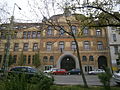
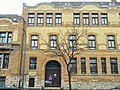
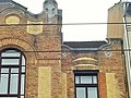
English: Stephen I of Hungary High School. Built in 1908. - Budapest District XIV
Magyar: Állami Főgimnázium (ma Szent István gimnázium), Giergl Kálmán és Korb Flóris, 1906-8 között épült szecessziós stílusú épület. Műemlék épület, azonosító: -8364. - Budapest, Zugló, Ajtósi Dürer sor 15
|
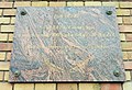
This is a category about a monument in Hungary. Identifier: -8364 |
Media in category "Stephen I of Hungary High School (Budapest)"
The following 44 files are in this category, out of 44 total.
-
 Ajtósi Dürer sor 15. emléktábla, 2020 Zugló.jpg 1,566 × 1,169; 525 KB
-
 Ajtósi Dürer Straße 15 von Szabó József Straße, 2023 Istvánmező.jpg 2,272 × 1,704; 1 MB
-
 Stephen I of Hungary High School (1908). - Budapest.jpg 2,272 × 1,704; 936 KB
-
 Stephen I of Hungary High School (1908). COA. - Budapest.jpg 2,272 × 1,704; 887 KB
-
 Szent István Gimnázium Budapest1.JPG 2,048 × 1,228; 699 KB
-
 Szent István Gimnázium Budapest2.JPG 2,048 × 1,536; 774 KB
-
 Szent István Gimnázium Budapest3.JPG 2,151 × 1,395; 674 KB
-
 Szent István Gimnázium. - Zugló, Istvánmező.jpg 2,272 × 1,704; 992 KB
-
 Szent István Gimnázium. Giergl és Korb építészek. - Zugló.jpg 2,272 × 1,704; 1 MB
-
 Szent István Gimnázium1.jpg 2,383 × 3,177; 1.76 MB
-
 Szent István Gimnázium10.jpg 2,978 × 1,880; 1.54 MB
-
 Szent István Gimnázium11.jpg 2,448 × 3,264; 2.81 MB
-
 Szent István Gimnázium12.jpg 2,955 × 2,448; 2.2 MB
-
 Szent István Gimnázium13.jpg 2,448 × 3,264; 2.28 MB
-
 Szent István Gimnázium14.jpg 2,448 × 3,264; 2.16 MB
-
 Szent István Gimnázium15.jpg 3,264 × 2,448; 2.44 MB
-
 Szent István Gimnázium16.jpg 1,216 × 2,457; 744 KB
-
 Szent István Gimnázium17.jpg 2,283 × 332; 197 KB
-
 Szent István Gimnázium18.jpg 2,377 × 3,169; 1.98 MB
-
 Szent István Gimnázium19.jpg 3,264 × 2,448; 2.11 MB
-
 Szent István Gimnázium2.jpg 3,018 × 2,361; 1.84 MB
-
 Szent István Gimnázium20.jpg 3,264 × 2,448; 2.34 MB
-
 Szent István Gimnázium21.jpg 1,766 × 908; 401 KB
-
 Szent István Gimnázium22.jpg 3,264 × 2,448; 2.46 MB
-
 Szent István Gimnázium23.jpg 3,191 × 2,393; 1.88 MB
-
 Szent István Gimnázium24.jpg 607 × 502; 152 KB
-
 Szent István Gimnázium25.jpg 1,325 × 441; 233 KB
-
 Szent István Gimnázium26.jpg 786 × 783; 243 KB
-
 Szent István Gimnázium27.jpg 3,191 × 2,393; 2.27 MB
-
 Szent István Gimnázium28.jpg 2,395 × 783; 486 KB
-
 Szent István Gimnázium29.jpg 3,141 × 2,355; 2.25 MB
-
 Szent István Gimnázium3.jpg 3,264 × 2,448; 2.46 MB
-
 Szent István Gimnázium30.jpg 2,399 × 3,197; 2.03 MB
-
 Szent István Gimnázium31.jpg 3,053 × 2,059; 1.77 MB
-
 Szent István Gimnázium32.jpg 3,264 × 2,448; 1.5 MB
-
 Szent István Gimnázium33.jpg 3,205 × 2,403; 1.14 MB
-
 Szent István Gimnázium34.jpg 3,102 × 2,244; 1.87 MB
-
 Szent István Gimnázium4.jpg 3,264 × 2,448; 1.98 MB
-
 Szent István Gimnázium5.jpg 2,855 × 2,287; 1.65 MB
-
 Szent István Gimnázium6.jpg 3,113 × 2,335; 1.97 MB
-
 Szent István Gimnázium7.jpg 2,448 × 3,264; 1.98 MB
-
 Szent István Gimnázium8.jpg 3,191 × 2,393; 2.05 MB
-
 Szent István Gimnázium9.jpg 2,776 × 1,893; 2.11 MB
-
 SZIG Ajtosi15.jpg 3,001 × 2,171; 3.48 MB


._-_Budapest.jpg)
._COA._-_Budapest.jpg)


