Category:Sterrestraat 5, Heusden
Jump to navigation
Jump to search
| Object location | | View all coordinates using: OpenStreetMap |
|---|
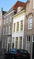
building in Heusden, Netherlands  | |||||
| Upload media | |||||
| Instance of | |||||
|---|---|---|---|---|---|
| Location | Heusden, North Brabant, Netherlands | ||||
| Street address |
| ||||
| Located on street | |||||
| Heritage designation |
| ||||
 | |||||
|
This is a category about rijksmonument number 22092
|
| Address |
|
Media in category "Sterrestraat 5, Heusden"
The following 5 files are in this category, out of 5 total.
-
 Heusden - Sterrestraat 5-7-9.jpg 1,944 × 2,592; 1.49 MB
-
 Heusden - Sterrestraat 5.jpg 888 × 1,548; 470 KB
-
 Heusden Panorama 1.JPG 4,299 × 2,257; 2.38 MB
-
 Oudheusdensestraat, Heusden P1150597.jpg 4,000 × 2,672; 5.62 MB
-
 Voorgevels - Heusden - 20112163 - RCE.jpg 800 × 1,200; 166 KB


