Category:Stettenberger Schlucht
Jump to navigation
Jump to search
| Object location | | View all coordinates using: OpenStreetMap |
|---|
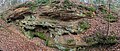
Deutsch: Die Stettenberger Schlucht ist eine Räthschlucht nahe Kalchreuth im mittelfränkischen Landkreis Erlangen-Höchstadt
Media in category "Stettenberger Schlucht"
The following 2 files are in this category, out of 2 total.
-
 Stettenberger Schlucht 01.jpg 8,042 × 3,450; 7.12 MB
-
 Stettenberger Schlucht 02.jpg 8,059 × 3,379; 6.03 MB

