Category:Stoh (peak)
Jump to navigation
Jump to search
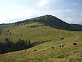
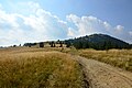
mountain on the border of Ukraine and Romania  Hora Stoh | |||||
| Upload media | |||||
| Instance of | |||||
|---|---|---|---|---|---|
| Location | Ivano-Frankivsk Oblast, Ukraine | ||||
| Mountain range |
| ||||
| Elevation above sea level |
| ||||
| Different from | |||||
 | |||||
Media in category "Stoh (peak)"
The following 8 files are in this category, out of 8 total.
-
 Góra Stoh.JPG 1,600 × 1,200; 351 KB
-
 Stig (marmarosh).jpg 1,200 × 900; 259 KB
-
 Stih marmaroskiy.jpg 4,160 × 3,120; 3.53 MB
-
 Stih tripoint 01.jpg 1,200 × 862; 173 KB
-
 Stih tripoint 02.jpg 785 × 1,200; 191 KB
-
 Stih tripoint 03.jpg 3,500 × 3,126; 1.44 MB
-
 Trójstyk na górze Stoh.JPG 1,600 × 1,200; 557 KB
-
 Гора Стіг.JPG 6,016 × 4,000; 3.48 MB
.jpg)


