Category:Storwood
Jump to navigation
Jump to search
village in the East Riding of Yorkshire, England, United Kingdom  | |||||
| Upload media | |||||
| Instance of | |||||
|---|---|---|---|---|---|
| Location | Cottingwith, East Riding of Yorkshire, Yorkshire and the Humber, England | ||||
 | |||||
English: Storwood is a hamlet in the East Riding of Yorkshire, England. It is situated approximately 6 miles (9.7 km) south west of Pocklington and lies to the south of the B1228 road on the south bank of the Pocklington Canal.
Subcategories
This category has the following 2 subcategories, out of 2 total.
G
- Gardham Lock (3 F)
H
- Hagg Bridge (5 F)
Media in category "Storwood"
The following 23 files are in this category, out of 23 total.
-

-
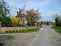
 Centre of Storwood looking north.jpg 640 × 479; 104 KB
-
 Farm Track - geograph.org.uk - 308359.jpg 640 × 299; 65 KB
-
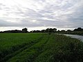
 Flooded Meadow - geograph.org.uk - 308351.jpg 640 × 426; 97 KB
-
-
 Gatehead Lane - geograph.org.uk - 414647.jpg 640 × 479; 118 KB
-
 Hagg Lane and Ballhall Lane junction - geograph.org.uk - 1299216.jpg 640 × 480; 57 KB
-
-

-
 Looking towards The Parks - geograph.org.uk - 308354.jpg 640 × 480; 137 KB
-

-
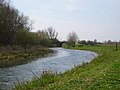
 Pocklington Canal - geograph.org.uk - 1777.jpg 640 × 480; 48 KB
-
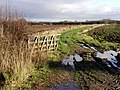
 Pocklington Canal from Gardham Lock - geograph.org.uk - 895781.jpg 640 × 480; 77 KB
-
 Pocklington Canal from Gardham Lock - geograph.org.uk - 895797.jpg 480 × 640; 96 KB
-

-
 Road Junction - geograph.org.uk - 308347.jpg 640 × 343; 52 KB
-

-
 Storwood Grange, Gatehead Lane - geograph.org.uk - 414655.jpg 640 × 479; 95 KB
-
 Storwood.jpg 640 × 479; 114 KB
-

-
 The Beck - geograph.org.uk - 295072.jpg 640 × 480; 88 KB
-
 The Pocklington Canal from Hagg Bridge - geograph.org.uk - 295075.jpg 640 × 480; 134 KB
-


