Category:Sula fyr
Jump to navigation
Jump to search
| Object location | | View all coordinates using: OpenStreetMap |
|---|
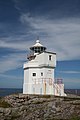
English: Sula Lighthouse
lighthouse in Norway  | |||||
| Upload media | |||||
| Instance of | |||||
|---|---|---|---|---|---|
| Made from material | |||||
| Location | Frøya Municipality, Trøndelag, Norway | ||||
| Located in or next to body of water | |||||
| Heritage designation | |||||
| Service entry |
| ||||
| Inception |
| ||||
| Significant event |
| ||||
| Height |
| ||||
 | |||||
Media in category "Sula fyr"
The following 11 files are in this category, out of 11 total.
-
 Lenses Sula lighthouse.jpg 2,002 × 3,028; 3.07 MB
-
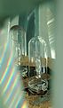 Lightbulbs Sula lighthouse.jpg 1,458 × 2,457; 1.36 MB
-
 Sula Frøya 03.jpg 3,028 × 2,002; 2.76 MB
-
 Sula fyr - panoramio.jpg 1,936 × 2,592; 783 KB
-
 Sula fyr 01.jpg 2,002 × 3,028; 2.21 MB
-
 Sula fyr.JPG 2,592 × 3,888; 3.65 MB
-
 Sula lighthouse, 1923. (8422941863).jpg 3,835 × 2,174; 4.84 MB
-
 Sula UBT-TO-076088 01 1.jpg 2,460 × 3,204; 1,023 KB
-
 Sula, Frøya - S-1602U2 112.jpg 4,000 × 3,113; 3.9 MB
-
 Sula, Frøya - S-1602U2 113.jpg 4,000 × 3,011; 4.31 MB
-
 View from Sula lighthouse.jpg 3,028 × 2,002; 1.95 MB


.jpg)


