Category:Suriname-Rivier (ship, 1910)
Jump to navigation
Jump to search
| Object location | | View all coordinates using: OpenStreetMap |
|---|
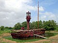
Lightship in Suriname  | |||||
| Upload media | |||||
| Instance of | |||||
|---|---|---|---|---|---|
| Location | Commewijne District, Suriname | ||||
| Country of registry | |||||
| Service entry |
| ||||
 | |||||
Español: Buque faro Suriname-Rivier, Fortaleza Nieuw-Amsterdam, Commewijne, Surinam.
English:
Ship
- Built by: Shipyard Conrad, Haarlem, Netherlands
- Launched: 1910
- Length o.a.: 24.85 m
- width: 6.83 m
- Displacement: 160 tons
Media in category "Suriname-Rivier (ship, 1910)"
The following 6 files are in this category, out of 6 total.
-

-
 Lichtschip met vuurtoren van voren gefotografeerd - Nieuw-Amsterdam - 20418106 - RCE.jpg 3,375 × 2,204; 3.91 MB
-
 Light ship (2719990186).jpg 853 × 1,246; 1.49 MB
-
 Light Ship in the Suriname River (17981261699).jpg 4,037 × 2,691; 1.89 MB
-
 Ship - Nieuw Amsterdam (23648030141).jpg 4,457 × 2,971; 7.32 MB
-
 Suriname 1 Lightship Fort Nieuw-Amsterdam.jpg 1,024 × 768; 131 KB

.jpg)
.jpg)
.jpg)
