Category:Swanenburghs hofje
Jump to navigation
Jump to search
| Object location | | View all coordinates using: OpenStreetMap |
|---|
 | |||||
| Upload media | |||||
| Instance of | |||||
|---|---|---|---|---|---|
| Location | Gouda, South Holland, Netherlands | ||||
| Street address |
| ||||
| Located on street |
| ||||
| Heritage designation |
| ||||
 | |||||
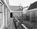
English: The Swanenburghs hofje was a charity for the housing of widows and spinsters.
Nederlands: Het Swanenburghshofje was een liefdadigheidsinstelling voor de huisvesting van weduwen en ongetrouwde vrouwen.
Hofje:
|
This is a category about rijksmonument number 16927
|
Poort:
|
This is a category about rijksmonument number 16820
|
| Address |
|
Media in category "Swanenburghs hofje"
The following 15 files are in this category, out of 15 total.
-
 Exterieur - Gouda - 20082178 - RCE.jpg 1,200 × 967; 249 KB
-
 Exterieur - Gouda - 20082179 - RCE.jpg 1,200 × 959; 383 KB
-
 Exterieur - Gouda - 20082180 - RCE.jpg 1,200 × 961; 293 KB
-
 Exterieur - Gouda - 20082181 - RCE.jpg 1,200 × 957; 310 KB
-
 Exterieur GEVELSTEEN - Gouda - 20262457 - RCE.jpg 773 × 1,200; 210 KB
-
 Exterieur, Rolwagensteeg 1-11 - Gouda - 20082175 - RCE.jpg 1,200 × 960; 197 KB
-
 Hofje plaats - Gouda - 20082174 - RCE.jpg 1,200 × 802; 224 KB
-
 Interieur - Gouda - 20082176 - RCE.jpg 1,200 × 954; 220 KB
-
 Interieur - Gouda - 20082177 - RCE.jpg 1,200 × 953; 244 KB
-
 Overzicht van de voorgevel - Gouda - 20379859 - RCE.jpg 1,200 × 1,180; 234 KB
-
 Overzicht voorgevel - Gouda - 20359083 - RCE.jpg 1,178 × 1,200; 412 KB
-
 Overzicht voorgevel met voorgevels buurpanden - Gouda - 20358545 - RCE.jpg 1,197 × 1,200; 363 KB
-
 Poortje Swanenburghs Hofje Gouda.jpg 2,848 × 2,134; 1.17 MB
-
 Rolwagensteeg, voorgevel - Gouda - 20082173 - RCE.jpg 1,200 × 799; 196 KB
-
 Swanenburghshof Groeneweg Gouda.jpg 1,935 × 1,290; 318 KB


