Category:Swatragh
Jump to navigation
Jump to search
village in the United Kingdom  | |||||
| Upload media | |||||
| Instance of | |||||
|---|---|---|---|---|---|
| Location | Northern Ireland | ||||
 | |||||
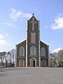
English: Swatragh is a small village in County Londonderry in Northern Ireland. Swatragh is situated on the main A29 Coleraine to Dundalk road, to the north of Maghera. The population was 435 people in the 2001 Census. It lies within the Magherafelt District Council area.
Media in category "Swatragh"
The following 78 files are in this category, out of 78 total.
-
 Ballyheige old school - geograph.org.uk - 587310.jpg 640 × 479; 68 KB
-
 Ballyheige Townland - geograph.org.uk - 587312.jpg 640 × 479; 74 KB
-
 Ballynamona Townland - geograph.org.uk - 587306.jpg 640 × 479; 92 KB
-
 Ballynamona Townland - geograph.org.uk - 587308.jpg 640 × 479; 54 KB
-
 Carnbane Townland - geograph.org.uk - 582465.jpg 640 × 479; 77 KB
-
 Craigavole AOH Hall - geograph.org.uk - 587389.jpg 640 × 479; 64 KB
-
 Emmet's GAA Club - geograph.org.uk - 587483.jpg 640 × 479; 53 KB
-
 Lower Keady - geograph.org.uk - 582431.jpg 640 × 479; 77 KB
-
 Lower Keady - geograph.org.uk - 582433.jpg 640 × 479; 50 KB
-
 Lower Keady - geograph.org.uk - 582462.jpg 640 × 479; 60 KB
-
 Road at Doonan - geograph.org.uk - 587485.jpg 640 × 479; 78 KB
-
 Road at Tamnyrankin - geograph.org.uk - 587385.jpg 640 × 479; 51 KB
-
 Ruin at Tirkane - geograph.org.uk - 587301.jpg 640 × 479; 76 KB
-
 Sheep at Tamnyrankin - geograph.org.uk - 587395.jpg 640 × 479; 81 KB
-
 St John the Baptist RC Church - geograph.org.uk - 141487.jpg 479 × 640; 68 KB
-
 Swatragh Church of Ireland - geograph.org.uk - 742083.jpg 640 × 479; 63 KB
-
 Tamnyrankin Townland - geograph.org.uk - 587380.jpg 640 × 479; 65 KB
-
 Tamnyrankin Townland - geograph.org.uk - 587384.jpg 640 × 479; 59 KB
-
 A29, Magheramore - geograph.org.uk - 742080.jpg 640 × 479; 49 KB
-
 Ballylame Townland - geograph.org.uk - 741375.jpg 640 × 479; 59 KB
-
 Ballylame Townland - geograph.org.uk - 741379.jpg 640 × 479; 70 KB
-
 Ballylame Townland - geograph.org.uk - 741389.jpg 640 × 479; 61 KB
-
 Ballymenagh Road - geograph.org.uk - 741312.jpg 640 × 479; 47 KB
-
 Ballymenagh Townland - geograph.org.uk - 741314.jpg 640 × 479; 48 KB
-
 Ballymenagh Townland - geograph.org.uk - 741317.jpg 640 × 479; 57 KB
-
 Ballynian Townland - geograph.org.uk - 582441.jpg 640 × 479; 80 KB
-
 Ballynian Townland - geograph.org.uk - 582445.jpg 640 × 479; 84 KB
-
 Ballynian Townland - geograph.org.uk - 582447.jpg 640 × 479; 79 KB
-
 Ballynian Townland - geograph.org.uk - 582450.jpg 640 × 479; 61 KB
-
 Carbalintober Townland - geograph.org.uk - 741339.jpg 640 × 479; 46 KB
-
 Carbalintober Townland - geograph.org.uk - 741367.jpg 640 × 479; 60 KB
-
 Chambered Grave, Ballylame - geograph.org.uk - 741383.jpg 640 × 479; 62 KB
-
 Cows at Crockanroe - geograph.org.uk - 587376.jpg 640 × 431; 53 KB
-
 Craigavole RC Church - geograph.org.uk - 741063.jpg 640 × 479; 72 KB
-
 Craigavole Townland - geograph.org.uk - 741046.jpg 640 × 479; 44 KB
-
 Craigavole Townland - geograph.org.uk - 741049.jpg 640 × 479; 53 KB
-
 Craigavole Townland - geograph.org.uk - 741056.jpg 640 × 479; 61 KB
-
 Craigavole Townland - geograph.org.uk - 741060.jpg 640 × 479; 85 KB
-
 Craigavole Townland - geograph.org.uk - 741093.jpg 640 × 479; 58 KB
-
 Crossland Road - geograph.org.uk - 741054.jpg 640 × 479; 47 KB
-
 Crossland Road - geograph.org.uk - 741058.jpg 640 × 479; 66 KB
-
 Drumbane Townland - geograph.org.uk - 741397.jpg 640 × 479; 76 KB
-
 Farm at Crockanroe - geograph.org.uk - 587378.jpg 640 × 479; 59 KB
-
 Farm at Lismoyle Road - geograph.org.uk - 741041.jpg 640 × 479; 74 KB
-
 Grove Road - geograph.org.uk - 741096.jpg 640 × 479; 58 KB
-
 Grove Road - geograph.org.uk - 741098.jpg 640 × 479; 52 KB
-
 Halfgayne Road - geograph.org.uk - 587429.jpg 640 × 479; 72 KB
-
 Knockoneill Townland - geograph.org.uk - 587424.jpg 640 × 479; 66 KB
-
 Knockoneill Townland - geograph.org.uk - 587425.jpg 640 × 479; 53 KB
-
 Knockoneill Townland - geograph.org.uk - 587426.jpg 640 × 479; 75 KB
-
 Lane at Ballynamona - geograph.org.uk - 587304.jpg 640 × 479; 108 KB
-
 Moneysharven Townland - geograph.org.uk - 582474.jpg 640 × 281; 35 KB
-
 Mullan's Town - geograph.org.uk - 587908.jpg 640 × 479; 55 KB
-
 Near Granaghan Hill - geograph.org.uk - 587444.jpg 640 × 479; 82 KB
-
 Near Swatragh - geograph.org.uk - 582459.jpg 640 × 479; 68 KB
-
 Near Swatragh - geograph.org.uk - 582471.jpg 640 × 479; 67 KB
-
 Near Upperlands - geograph.org.uk - 582469.jpg 640 × 479; 76 KB
-
 North of Swatragh - geograph.org.uk - 582458.jpg 640 × 479; 65 KB
-
 Picnic area at Moneysharven - geograph.org.uk - 529722.jpg 640 × 479; 86 KB
-
 Road at Ardnailler - geograph.org.uk - 587403.jpg 640 × 479; 66 KB
-
 Road at Mullan's Town - geograph.org.uk - 587909.jpg 640 × 479; 66 KB
-
 Road at Swatragh - geograph.org.uk - 582457.jpg 640 × 479; 73 KB
-
 Road at Tamnyrankin - geograph.org.uk - 587412.jpg 640 × 479; 67 KB
-
 Road at Tirkeeran - geograph.org.uk - 529717.jpg 640 × 280; 26 KB
-
 Road at Tirkeeran - geograph.org.uk - 529718.jpg 640 × 479; 37 KB
-
 Road at Upperlands - geograph.org.uk - 573651.jpg 640 × 293; 37 KB
-
 Road near Upperlands - geograph.org.uk - 573649.jpg 640 × 478; 64 KB
-
 Sheep at Ballynian - geograph.org.uk - 582439.jpg 640 × 479; 67 KB
-
 Sheep at Tirhugh - geograph.org.uk - 587432.jpg 640 × 479; 56 KB
-
 Sheep near Belleview - geograph.org.uk - 587415.jpg 640 × 479; 66 KB
-
 Slaghtneill Reservoir - geograph.org.uk - 587316.jpg 640 × 479; 74 KB
-
 Slaughtneill Road - geograph.org.uk - 587314.jpg 640 × 479; 47 KB
-
 Swatragh Presbyterian Church - geograph.org.uk - 582453.jpg 640 × 479; 44 KB
-
 Swatragh, Derry - County Londonderry - geograph.org.uk - 114807.jpg 640 × 479; 116 KB
-
 Tamnyrankin Road - geograph.org.uk - 587399.jpg 640 × 479; 75 KB
-
 Tamnyrankin Townland - geograph.org.uk - 587407.jpg 640 × 479; 68 KB
-
 Tergarvil Hibernian Hall - geograph.org.uk - 573754.jpg 640 × 479; 89 KB
-
 Tirnony Townland - geograph.org.uk - 587277.jpg 640 × 479; 64 KB


