Category:Swindermanpoortje (Steenwijk)
Jump to navigation
Jump to search
| Object location | | View all coordinates using: OpenStreetMap |
|---|
 | |||||
| Upload media | |||||
| Instance of | |||||
|---|---|---|---|---|---|
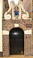
| Location | Steenwijk, Overijssel, Netherlands | ||||
| Heritage designation |
| ||||
 | |||||
|
This is a category about rijksmonument number 34598
|
| Address |
|
Media in category "Swindermanpoortje (Steenwijk)"
The following 2 files are in this category, out of 2 total.
-
 Naast 10, Poortje - Steenwijk - 20205618 - RCE.jpg 809 × 1,200; 151 KB
-
 Scholestraat bij 10 Steenwijk.jpg 1,944 × 3,416; 598 KB
