Category:TF-21
Jump to navigation
Jump to search
 | |||||
| Upload media | |||||
| Instance of | |||||
|---|---|---|---|---|---|
| Location | Tenerife, Atlantic Ocean, international waters | ||||
 | |||||
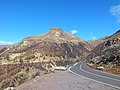
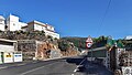
English: Pictures of road TF-21 on Tenerife, one of the islands of the Canary Islands in Spain. A part of the TF-21 is in the Parque nacional del Teide with the volcano Teide
Deutsch: Bilder der Straße TF-21 Cuesta de la Villa – La Orotava – El Portillo – Cañadas del Teide – Boca Tauce – Vilaflor – Granadilla de Abona, sie erschließt den Teide-Nationalpark mit dem Vulkan Pico de Teide, der gleichzeitig der höchste Gipfel Spaniens ist.
Subcategories
This category has the following 3 subcategories, out of 3 total.
Media in category "TF-21"
The following 16 files are in this category, out of 16 total.
-
 El Sombrero Tenerife.jpg 3,264 × 2,448; 1.59 MB
-
 J00 622 carretera cortada.jpg 5,706 × 3,804; 7.05 MB
-
 J00 629 Windbruch.jpg 5,931 × 3,954; 10.31 MB
-
 J00 861 Pinolere emalme.jpg 5,601 × 3,734; 6.51 MB
-
 J10 223 zona recreativa »Ramón caminero«.jpg 5,931 × 3,954; 2.19 MB
-
 J10 224 Waldeinsamkeit.jpg 5,604 × 3,736; 1.33 MB
-
 La Orotava, Santa Cruz de Tenerife, Spain - panoramio (24).jpg 4,608 × 2,592; 3.94 MB
-
 Road No TF-21, intersection, Vilaflor.jpg 4,011 × 2,268; 1.08 MB
-
 Road No TF-21, restaurant, Vilaflor.jpg 3,744 × 2,268; 2.2 MB
-
 Sombrero de Chasna, Tenerife (33260795346).jpg 2,756 × 2,067; 2.1 MB
-
 Teneriffa - Orotavatal - panoramio (1).jpg 2,247 × 1,229; 473 KB
-
 Teneriffa - Orotavatal - panoramio (2).jpg 4,242 × 2,397; 2.24 MB
-
 Teneriffa - Orotavatal - panoramio.jpg 4,320 × 3,240; 2.96 MB
-
 Teneriffa - Orotavatal - Pico del Teide - panoramio.jpg 4,320 × 3,240; 3.63 MB
-
 Teneriffa - Wolken über dem Orotavatal - panoramio.jpg 4,320 × 3,240; 2.12 MB
-
 Tf2.05 El Sombrero, Pico Viejo, Sombrerito.jpg 5,559 × 3,691; 5.01 MB


.jpg)

.jpg)
.jpg)
.jpg)


