Category:TF-436
Jump to navigation
Jump to search
| Camera location | | View all coordinates using: OpenStreetMap |
|---|
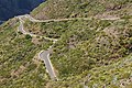
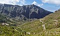
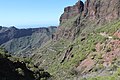
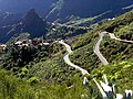
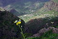
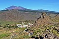
English: Pictures of the TF-436 a road near Santiago del Teide and Masca, belongs to the municipality Buenavista del Norte, on Tenerife one of the islands of the Canary Islands in Spain
| Upload media | |||||
| Instance of | |||||
|---|---|---|---|---|---|
| Location | Tenerife, Atlantic Ocean, international waters | ||||
| |||||
Subcategories
This category has only the following subcategory.
Media in category "TF-436"
The following 28 files are in this category, out of 28 total.
-
 Aparcamiento en Masca.jpg 1,280 × 720; 338 KB
-
 Bergstrasse nach Maska.jpg 1,600 × 1,200; 392 KB
-
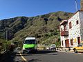 Bus 355 to Santiago del Teide.jpg 1,024 × 768; 445 KB
-
 Canaries Tenerife Teno TF 436 Vue Masca - panoramio (1).jpg 1,600 × 1,200; 963 KB
-
 Carretera de acceso, Valle del Masca, Tenerife, España, 2015.JPG 4,000 × 2,248; 3.77 MB
-
 Guagua, Valle del Masca, Tenerife, España, 2015.JPG 4,000 × 3,000; 4.74 MB
-
 J00 747 Santiago del Teide.jpg 5,742 × 3,828; 5.63 MB
-
 J00 750 Lomo de Guergues.jpg 5,847 × 3,898; 6.01 MB
-
 J00 751 Masca.jpg 5,706 × 3,804; 8.61 MB
-
 J00 752 Masca.jpg 5,604 × 3,736; 10.47 MB
-
 J00 753 Masca.jpg 5,604 × 3,736; 9.99 MB
-
 J00 754 Masca.jpg 5,706 × 3,804; 8.5 MB
-
 J00 755 Masca.jpg 5,604 × 3,736; 10.73 MB
-
 J00 756 Lomo de Guergues.jpg 5,742 × 3,828; 6.29 MB
-
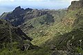
 Macizo de Teno 03.jpg 6,000 × 4,000; 26.16 MB
-
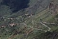
 Masca - Macizo de Teno 01.jpg 5,700 × 3,373; 16.88 MB
-
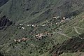
 Masca - panoramio (4).jpg 5,184 × 3,456; 5.25 MB
-
 Masca Road.jpg 2,592 × 1,944; 1.46 MB
-
 Masca-Strassen.JPG 1,535 × 1,152; 285 KB
-
 Road to Masca - great driving - Flickr - S. Rae.jpg 3,264 × 2,448; 2.47 MB
-
 Santiago del Teide kz1.JPG 4,657 × 3,493; 3.87 MB
-
 Serpentine, Masca, Tenerife.jpg 3,264 × 2,448; 1.91 MB
-
 SP-teneriffa-masca-zufahrt.jpg 1,215 × 807; 538 KB
-
 SP-teneriffa-santiagodelteide-strasse-masca.jpg 1,215 × 807; 393 KB
-
 Teide & Santiago del Teide.jpg 4,608 × 3,072; 3.66 MB
-
 Tenerife 1.JPG 600 × 450; 64 KB
-
 Vistas de Montaña - panoramio.jpg 2,048 × 1,536; 1.68 MB
-
 Дорога в Тено-Альто - panoramio.jpg 1,800 × 1,200; 921 KB


.jpg)


.jpg)


