Category:TIFF versions of Sanborn maps of Manhattan published 1910–11
Jump to navigation
Jump to search
Maps from:
- Insurance Maps of the City of New York Borough of Manhattan. Volume Four. (New York: Sanborn Map Company, 1910). Comprising title page, volume index, street index, and 55 maps (plates).
- Insurance Maps of the City of New York Borough of Manhattan. Volume Five. (New York: Sanborn Map Company, 1911), comprising 67 plates (maps) plus street index, title page, and volume index.
Source:
- The New York Public Library Digital Collection website, Atlas 114. Vol. 4, 1910.
- The New York Public Library Digital Collections website, Atlas 116.1. Vol. 5, 1911.
Media in category "TIFF versions of Sanborn maps of Manhattan published 1910–11"
The following 128 files are in this category, out of 128 total.
-
 Index NYPL1993019.tiff 5,410 × 7,212, 2 pages; 111.69 MB
-
 Index NYPL1998793.tiff 5,405 × 7,207, 2 pages; 111.51 MB
-

-

-
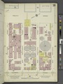
 Key NYPL1993020.tiff 5,410 × 7,212, 2 pages; 111.69 MB
-
 Key NYPL1998794.tiff 5,398 × 7,197, 2 pages; 111.21 MB
-
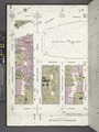
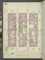
 Manhattan, V. 4, Plate No. 1 (Map bounded by 6th Ave., W. 25th St., 5th Ave., W. 22nd St.) NYPL1993021.tiff 5,398 × 7,190, 2 pages; 111.1 MB
-
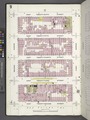
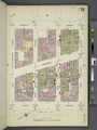
 Manhattan, V. 4, Plate No. 2 (Map bounded by 6th Ave., W. 28th St., 5th Ave., W. 25th St.) NYPL1993022.tiff 5,410 × 7,212, 2 pages; 111.69 MB
-
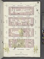
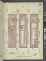
 Manhattan, V. 4, Plate No. 3 (Map bounded by 5th Ave., E. 25th St., 4th Ave., E. 22nd St.) NYPL1993023.tiff 5,398 × 7,190, 2 pages; 111.1 MB
-
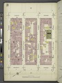
 Manhattan, V. 4, Plate No. 4 (Map bounded by 5th Ave., E. 28th St., 4th Ave., E. 25th St.) NYPL1993024.tiff 5,397 × 7,187, 2 pages; 111.04 MB
-
 Manhattan, V. 4, Plate No. 5 (Map bounded by 4th Ave., E. 25th St., 3rd Ave., E. 22nd St.) NYPL1993025.tiff 5,369 × 7,133, 2 pages; 109.63 MB
-
 Manhattan, V. 4, Plate No. 6 (Map bounded by 4th Ave., E. 28th St., 3rd Ave., E. 25th St.) NYPL1993026.tiff 5,397 × 7,187, 2 pages; 111.04 MB
-
 Manhattan, V. 4, Plate No. 7 (Map bounded by E. 26th St., 2nd Ave., E. 22nd St., 3rd Ave.) NYPL1993027.tiff 5,369 × 7,133, 2 pages; 109.63 MB
-
 Manhattan, V. 4, Plate No. 8 (Map bounded by E. 30th St., 2nd Ave., E. 26th St., 3rd Ave.) NYPL1993028.tiff 5,397 × 7,187, 2 pages; 111.04 MB
-
 Manhattan, V. 4, Plate No. 9 (Map bounded by E. 26th St., 1st Ave., E. 22nd St., 2nd Ave.) NYPL1993029.tiff 5,369 × 7,133, 2 pages; 109.63 MB
-
 Manhattan, V. 4, Plate No. 10 (Map bounded by E. 30th St., 1st Ave., E. 26th St., 2nd Ave.) NYPL1993030.tiff 5,397 × 7,187, 2 pages; 111.04 MB
-
 Manhattan, V. 4, Plate No. 11 (Map bounded by E. 26th St., Avenue A, E. 22nd St., 1st Ave.) NYPL1993031.tiff 5,369 × 7,133, 2 pages; 109.63 MB
-
 Manhattan, V. 4, Plate No. 12 (Map bounded by Avenue A, E. 25th St., East River, E. 22nd St.) NYPL1993032.tiff 5,374 × 7,143, 2 pages; 109.89 MB
-
 Manhattan, V. 4, Plate No. 13 (Map bounded by 1st Ave., E. 28th St., East River, E. 25th St.) NYPL1993033.tiff 5,374 × 7,143, 2 pages; 109.89 MB
-
 Manhattan, V. 4, Plate No. 14 (Map bounded by 1st Ave., E. 31st St., East River, E. 28th St.) NYPL1993034.tiff 5,359 × 7,115, 2 pages; 109.15 MB
-
 Manhattan, V. 4, Plate No. 15 (Map bounded by 6th Ave., W. 31st St., 5th Ave., W. 28th St.) NYPL1993035.tiff 5,353 × 7,102, 2 pages; 108.83 MB
-
 Manhattan, V. 4, Plate No. 16 (Map bounded by 6th Ave., W. 34th St., 5th Ave., W. 31st St.) NYPL1993036.tiff 5,359 × 7,115, 2 pages; 109.15 MB
-
 Manhattan, V. 4, Plate No. 17 (Map bounded by 5th Ave., E. 31st St., 4th Ave., E. 28th St.) NYPL1993037.tiff 5,353 × 7,102, 2 pages; 108.83 MB
-
 Manhattan, V. 4, Plate No. 18 (Map bounded by 5th Ave., E. 34th St., 4th Ave., E. 31st St.) NYPL1993038.tiff 5,359 × 7,115, 2 pages; 109.15 MB
-
 Manhattan, V. 4, Plate No. 19 (Map bounded by 4th Ave., E. 31st St., 3rd Ave., E. 28th St.) NYPL1993039.tiff 5,353 × 7,102, 2 pages; 108.83 MB
-
 Manhattan, V. 4, Plate No. 20 (Map bounded by 4th Ave., E. 34th St., 3rd Ave., E. 31st St.) NYPL1993040.tiff 5,359 × 7,115, 2 pages; 109.15 MB
-
 Manhattan, V. 4, Plate No. 21 (Map bounded by E. 34th St., 2nd Ave., E. 30th St., 3rd Ave.) NYPL1993041.tiff 5,397 × 7,187, 2 pages; 111.04 MB
-
 Manhattan, V. 4, Plate No. 22 (Map bounded by E. 38th St., 2nd Ave., E. 34th St., 3rd Ave.) NYPL1993042.tiff 5,359 × 7,115, 2 pages; 109.15 MB
-
 Manhattan, V. 4, Plate No. 23 (Map bounded by E. 34th St., 1st Ave., E. 30th St., 2nd Ave.) NYPL1993043.tiff 5,397 × 7,187, 2 pages; 111.04 MB
-
 Manhattan, V. 4, Plate No. 24 (Map bounded by E. 38th St., 1st Ave., E. 34th St., 2nd Ave.) NYPL1993044.tiff 5,359 × 7,115, 2 pages; 109.15 MB
-
 Manhattan, V. 4, Plate No. 25 (Map bounded by E. 34th St., E. 30th St., 1st Ave.) NYPL1993045.tiff 5,397 × 7,187, 2 pages; 111.04 MB
-
 Manhattan, V. 4, Plate No. 26 (Map bounded by E. 38th St., East River, E. 34th St., 1st Ave.) NYPL1993046.tiff 5,359 × 7,115, 2 pages; 109.15 MB
-
 Manhattan, V. 4, Plate No. 27 (Map bounded by 6th Ave., W. 37th St., 5th Ave., W. 34th St.) NYPL1993047.tiff 5,398 × 7,190, 2 pages; 111.1 MB
-
 Manhattan, V. 4, Plate No. 28 (Map bounded by 6th Ave., W. 40th St., 5th Ave., W. 37th St.) NYPL1993048.tiff 5,359 × 7,115, 2 pages; 109.15 MB
-
 Manhattan, V. 4, Plate No. 29 (Map bounded by 5th Ave., E. 37th St., Park Ave., E. 34th St.) NYPL1993049.tiff 5,398 × 7,190, 2 pages; 111.1 MB
-
 Manhattan, V. 4, Plate No. 30 (Map bounded by 5th Ave., E. 40th St., Park Ave., E. 37th St.) NYPL1993050.tiff 5,359 × 7,115, 2 pages; 109.15 MB
-
 Manhattan, V. 4, Plate No. 31 (Map bounded by Park Ave., E. 37th St., 3rd Ave., E. 34th St.) NYPL1993051.tiff 5,398 × 7,190, 2 pages; 111.1 MB
-
 Manhattan, V. 4, Plate No. 32 (Map bounded by Park Ave., E. 40th St., 3rd Ave., E. 37th St.) NYPL1993052.tiff 5,359 × 7,115, 2 pages; 109.15 MB
-
 Manhattan, V. 4, Plate No. 33 (Map bounded by E. 42nd St., 2nd Ave., E. 38th St., 3rd Ave.) NYPL1993053.tiff 5,398 × 7,190, 2 pages; 111.1 MB
-
 Manhattan, V. 4, Plate No. 34 (Map bounded by E. 46th St., 2nd Ave., E. 42nd St., 3rd Ave.) NYPL1993054.tiff 5,359 × 7,115, 2 pages; 109.15 MB
-
 Manhattan, V. 4, Plate No. 35 (Map bounded by E. 42nd St., 1st Ave., E. 38th St., 2nd Ave.) NYPL1993055.tiff 5,398 × 7,190, 2 pages; 111.1 MB
-
 Manhattan, V. 4, Plate No. 36 (Map bounded by E. 46th St., 1st Ave., E. 42nd St., 2nd Ave.) NYPL1993056.tiff 5,359 × 7,115, 2 pages; 109.15 MB
-
 Manhattan, V. 4, Plate No. 37 (Map bounded by E. 42nd St., E. 38th St., 1st Ave.) NYPL1993057.tiff 5,398 × 7,190, 2 pages; 111.1 MB
-
 Manhattan, V. 4, Plate No. 38 (Map bounded by E. 46th St., East River, E. 42nd St., 1st Ave.) NYPL1993058.tiff 5,359 × 7,115, 2 pages; 109.15 MB
-
 Manhattan, V. 4, Plate No. 39 (Map bounded by 6th Ave., W. 43rd St., 5th Ave., W. 40th St.) NYPL1993059.tiff 5,398 × 7,190, 2 pages; 111.1 MB
-
 Manhattan, V. 4, Plate No. 40 (Map bounded by 6th Ave., W. 46th St., 5th Ave., W. 43rd St.) NYPL1993060.tiff 5,359 × 7,115, 2 pages; 109.15 MB
-
 Manhattan, V. 4, Plate No. 41 (Map bounded by 5th Ave., E. 43rd St., Park Ave., E. 40th St.) NYPL1993061.tiff 5,378 × 7,151, 2 pages; 110.09 MB
-
 Manhattan, V. 4, Plate No. 42 (Map bounded by 5th Ave., E. 46th St., E. 43rd St.) NYPL1993062.tiff 5,359 × 7,115, 2 pages; 109.15 MB
-
 Manhattan, V. 4, Plate No. 43 (Map bounded by Park Ave., E. 43rd St., 3rd Ave., E. 40th St.) NYPL1993063.tiff 5,366 × 7,127, 2 pages; 109.48 MB
-
 Manhattan, V. 4, Plate No. 44 (Map bounded by Park Ave., E. 46th St., 3rd Ave., E. 43rd St.) NYPL1993064.tiff 5,359 × 7,115, 2 pages; 109.15 MB
-
 Manhattan, V. 4, Plate No. 45 (Map bounded by 6th Ave., W. 49th St., 5th Ave., W. 46th St.) NYPL1993065.tiff 5,346 × 7,090, 2 pages; 108.5 MB
-
 Manhattan, V. 4, Plate No. 46 (Map bounded by 6th Ave., W. 42nd St., 5th Ave., W. 49th St.) NYPL1993066.tiff 5,359 × 7,115, 2 pages; 109.15 MB
-
 Manhattan, V. 4, Plate No. 47 (Map bounded by 5th Ave., E. 49th St., Park Ave., E. 46th St.) NYPL1993067.tiff 5,306 × 7,012, 2 pages; 106.51 MB
-
 Manhattan, V. 4, Plate No. 48 (Map bounded by 5th Ave., E. 52nd St., Park Ave., E. 49th St.) NYPL1993068.tiff 5,331 × 7,060, 2 pages; 107.74 MB
-
 Manhattan, V. 4, Plate No. 49 (Map bounded by Park Ave., E. 49th St., 3rd Ave., E. 46th St.) NYPL1993069.tiff 5,293 × 6,989, 2 pages; 105.9 MB
-
 Manhattan, V. 4, Plate No. 50 (Map bounded by Park Ave., E. 52nd St., 3rd Ave., E. 49th St.) NYPL1993070.tiff 5,331 × 7,060, 2 pages; 107.74 MB
-
 Manhattan, V. 4, Plate No. 51 (Map bounded by E. 50th St., 2nd Ave., E. 46th St., 3rd Ave.) NYPL1993071.tiff 5,333 × 7,065, 2 pages; 107.86 MB
-
 Manhattan, V. 4, Plate No. 52 (Map bounded by E. 52nd St., 1st Ave., E. 50th St., 2nd Ave., 3rd Ave.) NYPL1993072.tiff 5,252 × 6,911, 2 pages; 103.91 MB
-
 Manhattan, V. 4, Plate No. 53 (Map bounded by E. 50th St., 1st Ave., E. 46th St., 2nd Ave.) NYPL1993073.tiff 5,308 × 7,018, 2 pages; 106.64 MB
-
 Manhattan, V. 4, Plate No. 54 (Map bounded by E. 50th St., East River, E. 46th St., 1st Ave.) NYPL1993074.tiff 5,311 × 7,023, 2 pages; 106.78 MB
-
 Manhattan, V. 4, Plate No. 55 (Map bounded by E. 52nd St., East River, E. 50th St., 1st Ave.) NYPL1993075.tiff 5,333 × 7,065, 2 pages; 107.86 MB
-
 Manhattan, V. 5, Plate No. 1 (Map bounded by Hudson River, West 25th St., Eleventh Ave., West 23rd st.) NYPL1998795.tiff 5,398 × 7,197, 2 pages; 111.21 MB
-
 Manhattan, V. 5, Plate No. 2 (Map bounded by Hudson River, West 28th St., 11th Ave., West 25th St.) NYPL1998796.tiff 5,398 × 7,197, 2 pages; 111.21 MB
-
 Manhattan, V. 5, Plate No. 3 (Map bounded by 11th Ave., West 25th St., 10th Ave., West 22nd St.) NYPL1998797.tiff 5,350 × 7,133, 2 pages; 109.24 MB
-
 Manhattan, V. 5, Plate No. 4 (Map bounded by 11th Ave., West 28th St., 10th Ave., W. 25th St.) NYPL1998798.tiff 5,363 × 7,151, 2 pages; 109.78 MB
-
 Manhattan, V. 5, Plate No. 5 (Map bounded by 10th Ave., West 25th St., 9th Ave., West 22nd St.) NYPL1998799.tiff 5,311 × 7,082, 2 pages; 107.67 MB
-
 Manhattan, V. 5, Plate No. 6 (Map bounded by 10th Ave., West 28th St., Ninth Ave., West 25th Ave.) NYPL1998800.tiff 5,362 × 7,150, 2 pages; 109.75 MB
-
 Manhattan, V. 5, Plate No. 7 (Map bounded by 9th Ave., West 25th St., 8th Ave., West 22nd St.) NYPL1998801.tiff 5,299 × 7,066, 2 pages; 107.19 MB
-
 Manhattan, V. 5, Plate No. 8 (Map bounded by 9th Ave., West 28th St., 8th Ave., West 25th St.) NYPL1998802.tiff 5,412 × 7,216, 2 pages; 111.79 MB
-
 Manhattan, V. 5, Plate No. 9 (Map bounded by 8th Ave., West 25th St., 7th Ave., West 22nd St.) NYPL1998803.tiff 5,319 × 7,092, 2 pages; 107.99 MB
-
 Manhattan, V. 5, Plate No. 10 (Map bounded by 8th Ave., West 28th St., 7th Ave., West 25th St.) NYPL1998804.tiff 5,412 × 7,216, 2 pages; 111.79 MB
-
 Manhattan, V. 5, Plate No. 11 (Map bounded by 7th Ave., West 25th St., 6th Ave., West 22nd St.) NYPL1998805.tiff 5,319 × 7,092, 2 pages; 107.99 MB
-
 Manhattan, V. 5, Plate No. 12 (Map bounded by 7th Ave., West 28th St., 6th Ave., West 25th St.) NYPL1998806.tiff 5,412 × 7,216, 2 pages; 111.79 MB
-
 Manhattan, V. 5, Plate No. 13 (Map bounded by Hudson River, West 31st St., 11th Ave., West 28th St.) NYPL1998807.tiff 5,319 × 7,092, 2 pages; 107.99 MB
-
 Manhattan, V. 5, Plate No. 14 (Map bounded by Hudson River, West 34th St., 11th Ave., West 31st St.) NYPL1998808.tiff 5,412 × 7,216, 2 pages; 111.79 MB
-
 Manhattan, V. 5, Plate No. 15 (Map bounded by 11th Ave., West 31st St., 10th Ave., West 28th St.) NYPL1998809.tiff 5,319 × 7,092, 2 pages; 107.99 MB
-
 Manhattan, V. 5, Plate No. 16 (Map bounded by 11th Ave., West 34th St., 10th Ave., West 31st St.) NYPL1998810.tiff 5,412 × 7,216, 2 pages; 111.79 MB
-
 Manhattan, V. 5, Plate No. 17 (Map bounded by 10th Ave., West 31st St., 9th Ave., West 28th St.) NYPL1998811.tiff 5,343 × 7,124, 2 pages; 108.96 MB
-
 Manhattan, V. 5, Plate No. 18 (Map bounded by 10th Ave., West 34th St., 9th Ave., West 31st St.) NYPL1998812.tiff 5,412 × 7,216, 2 pages; 111.79 MB
-
 Manhattan, V. 5, Plate No. 19 (Map bounded by 9th Ave., West 31st St., 8th Ave., West 28th St.) NYPL1998813.tiff 5,343 × 7,124, 2 pages; 108.96 MB
-
 Manhattan, V. 5, Plate No. 20 (Map bounded by 9th Ave., West 34th St., 8th Ave., West 31st St.) NYPL1998814.tiff 5,412 × 7,216, 2 pages; 111.79 MB
-
 Manhattan, V. 5, Plate No. 21 (Map bounded by 8th Ave., West 31st St., 7th Ave., West 28th St.) NYPL1998815.tiff 5,343 × 7,124, 2 pages; 108.96 MB
-
 Manhattan, V. 5, Plate No. 22 (Map bounded by 8th Ave., West 34th St., 7th Ave., West 31st St.) NYPL1998816.tiff 5,412 × 7,216, 2 pages; 111.79 MB
-
 Manhattan, V. 5, Plate No. 23 (Map bounded by 7th Ave., West 34th St., 6th Ave., West 28th St.) NYPL1998817.tiff 5,355 × 7,139, 2 pages; 109.44 MB
-
 Manhattan, V. 5, Plate No. 24 (Map bounded by 7th Ave., West 34th St., 6th Ave., West 28th St.) NYPL1998818.tiff 5,412 × 7,216, 2 pages; 111.79 MB
-
 Manhattan, V. 5, Plate No. 25 (Map bounded by Hudson River, West 37th St., 11th Ave., West 34th St.) NYPL1998819.tiff 5,355 × 7,139, 2 pages; 109.44 MB
-
 Manhattan, V. 5, Plate No. 26 (Map bounded by Hudson River, West 40th St., 11th Ave., West 37th St.) NYPL1998820.tiff 5,405 × 7,207, 2 pages; 111.51 MB
-
 Manhattan, V. 5, Plate No. 27 (Map bounded by 11th Ave., West 37th St., 10th Ave., West 34th St.) NYPL1998821.tiff 5,339 × 7,119, 2 pages; 108.8 MB
-
 Manhattan, V. 5, Plate No. 28 (Map bounded by 11th Ave., West 40th St., 10th Ave., West 37th St.) NYPL1998822.tiff 5,412 × 7,216, 2 pages; 111.79 MB
-
 Manhattan, V. 5, Plate No. 29 (Map bounded by 10th Ave., West 37th St., 9th Ave., West 34th St.) NYPL1998823.tiff 5,333 × 7,110, 2 pages; 108.54 MB
-
 Manhattan, V. 5, Plate No. 30 (Map bounded by 10th Ave., West 40th St., 9th Ave., West 37th St.) NYPL1998824.tiff 5,412 × 7,216, 2 pages; 111.79 MB
-
 Manhattan, V. 5, Plate No. 31 (Map bounded by 9th Ave., West 37th St., 8th Ave., West 34th St.) NYPL1998825.tiff 5,333 × 7,110, 2 pages; 108.54 MB
-
 Manhattan, V. 5, Plate No. 32 (Map bounded by 9th Ave., West 40th St., 8th Ave., West 37th St.) NYPL1998826.tiff 5,380 × 7,173, 2 pages; 110.47 MB
-
 Manhattan, V. 5, Plate No. 33 (Map bounded by 8th Ave., West 37th St., 7th Ave., West 34th St.) NYPL1998827.tiff 5,333 × 7,110, 2 pages; 108.54 MB
-
 Manhattan, V. 5, Plate No. 34 (Map bounded by 8th Ave., West 40th St., 7th Ave., West 37th St.) NYPL1998828.tiff 5,381 × 7,174, 2 pages; 110.51 MB
-
 Manhattan, V. 5, Plate No. 35 (Map bounded by 7th Ave., West 37th St., 6th Ave., West 34th St.) NYPL1998829.tiff 5,339 × 7,119, 2 pages; 108.8 MB
-
 Manhattan, V. 5, Plate No. 36 (Map bounded by 7th Ave., West 40th St., 6th Ave., West 37th St.) NYPL1998830.tiff 5,399 × 7,199, 2 pages; 111.26 MB
-
 Manhattan, V. 5, Plate No. 37 (Map bounded by Hudson River, West 43rd St., 11th Ave., West 40th St.) NYPL1998831.tiff 5,314 × 7,086, 2 pages; 107.79 MB
-
 Manhattan, V. 5, Plate No. 38 (Map bounded by Hudson River, West 46th St., 11th Ave., West 43rd St.) NYPL1998832.tiff 5,383 × 7,177, 2 pages; 110.59 MB
-
 Manhattan, V. 5, Plate No. 39 (Map bounded by 11th Ave., West 43rd St., 10th Ave., West 40th St.) NYPL1998833.tiff 5,330 × 7,106, 2 pages; 108.42 MB
-
 Manhattan, V. 5, Plate No. 40 (Map bounded by 11th Ave., West 46th St., 10th Ave., West 43rd St.) NYPL1998834.tiff 5,387 × 7,183, 2 pages; 110.77 MB
-
 Manhattan, V. 5, Plate No. 41 (Map bounded by 10th Ave., West 43rd St., 9th Ave., West 40th St.) NYPL1998835.tiff 5,330 × 7,106, 2 pages; 108.42 MB
-
 Manhattan, V. 5, Plate No. 42 (Map bounded by 10th Ave., West 46th St., 9th Ave., West 43rd St.) NYPL1998836.tiff 5,387 × 7,183, 2 pages; 110.77 MB
-
 Manhattan, V. 5, Plate No. 43 (Map bounded by 9th Ave., West 43rd St., 8th Ave., West 40th St.) NYPL1998837.tiff 5,309 × 7,079, 2 pages; 107.59 MB
-
 Manhattan, V. 5, Plate No. 44 (Map bounded by 9th Ave., West 46th St., 8th Ave., West 43rd St.) NYPL1998838.tiff 5,398 × 7,197, 2 pages; 111.21 MB
-
 Manhattan, V. 5, Plate No. 45 (Map bounded by 8th Ave., West 43rd St., 7th Ave, Broadway, West 40th St.) NYPL1998839.tiff 5,342 × 7,123, 2 pages; 108.93 MB
-
 Manhattan, V. 5, Plate No. 46 (Map bounded by 8th Ave., West 46th St., Broadway, West 43rd St.) NYPL1998840.tiff 5,374 × 7,166, 2 pages; 110.24 MB
-
 Manhattan, V. 5, Plate No. 47 (Map bounded by 7th Ave., West 43rd St., 6th Ave., West 40th St.) NYPL1998841.tiff 5,342 × 7,123, 2 pages; 108.93 MB
-
 Manhattan, V. 5, Plate No. 48 (Map bounded by Broadway, West 46th St., 6th Ave., West 43rd St.) NYPL1998842.tiff 5,388 × 7,184, 2 pages; 110.8 MB
-
 Manhattan, V. 5, Plate No. 49 (Map bounded by Hudson River, West 49th St., 11th Ave., West 46th St.) NYPL1998843.tiff 5,342 × 7,123, 2 pages; 108.93 MB
-
 Manhattan, V. 5, Plate No. 50 (Map bounded by Hudson River, West 52nd St., 11th Ave., West 49th St.) NYPL1998844.tiff 5,402 × 7,203, 2 pages; 111.39 MB
-
 Manhattan, V. 5, Plate No. 51 (Map bounded by 11th Ave., West 49th St., 10th Ave., West 46th St.) NYPL1998845.tiff 5,352 × 7,136, 2 pages; 109.33 MB
-
 Manhattan, V. 5, Plate No. 52 (Map bounded by 11th Ave., West 52nd St., 10th Ave., West 49th St.) NYPL1998846.tiff 5,373 × 7,164, 2 pages; 110.19 MB
-
 Manhattan, V. 5, Plate No. 53 (Map bounded by 10th Ave., West 49th St., 9th Ave., West 46th St.) NYPL1998847.tiff 5,352 × 7,136, 2 pages; 109.33 MB
-
 Manhattan, V. 5, Plate No. 54 (Map bounded by 10th Ave., West 52nd St., 9th Ave., West 49th St.) NYPL1998848.tiff 5,373 × 7,164, 2 pages; 110.19 MB
-
 Manhattan, V. 5, Plate No. 55 (Map bounded by 9th Ave., West 49th St., 8th Ave., West 46th St.) NYPL1998849.tiff 5,352 × 7,136, 2 pages; 109.33 MB
-
 Manhattan, V. 5, Plate No. 56 (Map bounded by 9th Ave., West 52nd St., 8th Ave., West 49th St.) NYPL1998850.tiff 5,362 × 7,149, 2 pages; 109.73 MB
-
 Manhattan, V. 5, Plate No. 57 (Map bounded by 8th Ave., West 49th St., 7th Ave., West 46th St.) NYPL1998851.tiff 5,352 × 7,136, 2 pages; 109.33 MB
-
 Manhattan, V. 5, Plate No. 58 (Map bounded by 8th Ave., West 52nd St., 7th Ave., West 49th St.) NYPL1998852.tiff 5,377 × 7,169, 2 pages; 110.35 MB
-
 Manhattan, V. 5, Plate No. 59 (Map bounded by Broadway, West 49th St., 6th Ave., West 46th St.) NYPL1998853.tiff 5,352 × 7,136, 2 pages; 109.33 MB
-
 Manhattan, V. 5, Plate No. 60 (Map bounded by 7th Ave., West 52nd St., 6th Ave., West 49th St.) NYPL1998854.tiff 5,406 × 7,208, 2 pages; 111.54 MB
-
 Manhattan, V. 5, Plate No. 61 (Map bounded by Hudson River, 13th Ave.) NYPL1998855.tiff 5,352 × 7,136, 2 pages; 109.33 MB
-
 Manhattan, V. 5, Plate No. 62 (Map bounded by Hudson River, 13th Ave.) NYPL1998856.tiff 5,355 × 7,140, 2 pages; 109.45 MB
-
 Manhattan, V. 5, Plate No. 63 (Map bounded by Hudson River, 12th Ave.) NYPL1998857.tiff 5,352 × 7,136, 2 pages; 109.33 MB
-
 Manhattan, V. 5, Plate No. 64 (Map bounded by Hudson River, 12th Ave.) NYPL1998858.tiff 5,380 × 7,174, 2 pages; 110.49 MB
-
 Manhattan, V. 5, Plate No. 65 (Map bounded by Hudson River, 12th Ave.) NYPL1998859.tiff 5,318 × 7,090, 2 pages; 107.93 MB
-
 Manhattan, V. 5, Plate No. 66 (Map bounded by Hudson River, 12th Ave.) NYPL1998860.tiff 5,380 × 7,174, 2 pages; 110.49 MB
-
 Manhattan, V. 5, Plate No. 67 (Map bounded by Hudson River, 12th Ave.) NYPL1998861.tiff 5,381 × 7,175, 2 pages; 110.52 MB