Category:TIFF versions of Sanborn maps of Manhattan published in 1904
Jump to navigation
Jump to search
Maps from: Insurance Maps of the City of New York Borough of Manhattan. Volume Three. (New York: Sanborn Map Company, 1904), comprising 54 maps (plates), plus title page, street index, map of the high pressure fire system, and two versions of the volume key (this category includes only one version).
Online at The New York Public Library Digital Collections website, Atlas 112. Vol. 3, 1904.
Media in category "TIFF versions of Sanborn maps of Manhattan published in 1904"
The following 58 files are in this category, out of 58 total.
-

-
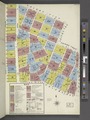
 Index NYPL1996608.tiff 5,367 × 7,157, 2 pages; 109.96 MB
-
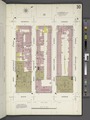
 Key continued NYPL1996610.tiff 5,405 × 7,206, 2 pages; 111.49 MB
-
 Key continued NYPL1996611.tiff 5,405 × 7,206, 2 pages; 111.49 MB
-
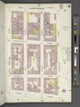
 Manhattan, V. 3, Plate No. 1 (Map bounded by West St., Morton St., Hudson St., W. Houston St.) NYPL1996612.tiff 5,367 × 7,157, 2 pages; 109.96 MB
-
 Manhattan, V. 3, Plate No. 2 (Map bounded by West St., Christopher St., Hudson St., Morton St.) NYPL1996613.tiff 5,405 × 7,206, 2 pages; 111.49 MB
-
 Manhattan, V. 3, Plate No. 3 (Map bounded by Hudson St., Morton St., Bedford St., W. Houston St.) NYPL1996614.tiff 5,367 × 7,157, 2 pages; 109.96 MB
-
 Manhattan, V. 3, Plate No. 4 (Map bounded by Hudson St., Christopher St., W. 4th St., Morton St.) NYPL1996615.tiff 5,405 × 7,206, 2 pages; 111.49 MB
-

-

-
 Manhattan, V. 3, Plate No. 7 (Map bounded by W. 4th St., W. Broadway, W. Houston St., Macdougal St.) NYPL1996618.tiff 5,389 × 7,186, 2 pages; 110.86 MB
-
 Manhattan, V. 3, Plate No. 8 (Map bounded by W. 4th St., Mercer St., W. Houston St., W. Broadway) NYPL1996619.tiff 5,407 × 7,209, 2 pages; 111.58 MB
-

-
 Manhattan, V. 3, Plate No. 10 (Map bounded by E. 4th St., Bowery, E. Houston St., Elm St.) NYPL1996621.tiff 5,407 × 7,209, 2 pages; 111.58 MB
-
 Manhattan, V. 3, Plate No. 11 (Map bounded by W. 11th St., Greenwich St., Christopher St., West St.) NYPL1996622.tiff 5,351 × 7,135, 2 pages; 109.29 MB
-
 Manhattan, V. 3, Plate No. 12 (Map bounded by W. 11th St., Bleecker St., Christopher St., Greenwich St.) NYPL1996623.tiff 5,407 × 7,209, 2 pages; 111.58 MB
-
 Manhattan, V. 3, Plate No. 13 (Map bounded by West St., W. 12th St., Hudson St., W. 11th St.) NYPL1996624.tiff 5,387 × 7,182, 2 pages; 110.75 MB
-
 Manhattan, V. 3, Plate No. 14 (Map bounded by West St., Gansevoort St., Hudson St., W. 12th St.) NYPL1996625.tiff 5,407 × 7,209, 2 pages; 111.58 MB
-
 Manhattan, V. 3, Plate No. 15 (Map bounded by Bleecker St., W. 11th St., Greenwich Ave., W. 10th St.) NYPL1996626.tiff 5,362 × 7,149, 2 pages; 109.73 MB
-
 Manhattan, V. 3, Plate No. 16 (Map bounded by Hudson St., Jane St., Greenwich Ave., W. 11th St.) NYPL1996627.tiff 5,403 × 7,204, 2 pages; 111.42 MB
-
 Manhattan, V. 3, Plate No. 17 (Map bounded by W. 11th St., 6th Ave., Washington Place., 4th St.) NYPL1996628.tiff 5,362 × 7,149, 2 pages; 109.73 MB
-
 Manhattan, V. 3, Plate No. 18 (Map bounded by 6th Ave., W. 8th St., 5th Ave., W. 4th St.) NYPL1996629.tiff 5,403 × 7,204, 2 pages; 111.42 MB
-
 Manhattan, V. 3, Plate No. 19 (Map bounded by 6th Ave., W. 11th St., 5th Ave., W. 8th St.) NYPL1996630.tiff 5,362 × 7,149, 2 pages; 109.73 MB
-
 Manhattan, V. 3, Plate No. 20 (Map bounded by 6th Ave., W. 14th St., 5th Ave., W. 11th St.) NYPL1996631.tiff 5,383 × 7,178, 2 pages; 110.61 MB
-
 Manhattan, V. 3, Plate No. 21 (Map bounded by E. 9th St., Wooster St., W. 4th St., 5th Ave.) NYPL1996632.tiff 5,362 × 7,149, 2 pages; 109.73 MB
-
 Manhattan, V. 3, Plate No. 22 (Map bounded by E. 14th St., University Place, E. 9th St., 5th Ave.) NYPL1996633.tiff 5,383 × 7,178, 2 pages; 110.61 MB
-
 Manhattan, V. 3, Plate No. 23 (Map bounded by E. 9th St., Broadway, W. 4th St., Washington Sq.) NYPL1996634.tiff 5,362 × 7,149, 2 pages; 109.73 MB
-
 Manhattan, V. 3, Plate No. 24 (Map bounded by E. 9th St., 4th Ave., E. 4th Ave., Broadway) NYPL1996635.tiff 5,383 × 7,178, 2 pages; 110.61 MB
-
 Manhattan, V. 3, Plate No. 25 (Map bounded by E. 14th St., Broadway, E. 9th St., University Place) NYPL1996636.tiff 5,368 × 7,157, 2 pages; 109.98 MB
-
 Manhattan, V. 3, Plate No. 26 (Map bounded by E. 14th St., 4th Ave., E. 9th St., Broadway) NYPL1996637.tiff 5,383 × 7,178, 2 pages; 110.61 MB
-
 Manhattan, V. 3, Plate No. 27 (Map bounded by 7th Ave., W. 14th St., 6th Ave., W. 11th St.) NYPL1996638.tiff 5,368 × 7,157, 2 pages; 109.98 MB
-
 Manhattan, V. 3, Plate No. 28 (Map bounded by 7th Ave., W. 16th St., 6th Ave., W. 14th St.) NYPL1996639.tiff 5,383 × 7,178, 2 pages; 110.61 MB
-
 Manhattan, V. 3, Plate No. 29 (Map bounded by 7th Ave., W. 19th St., 6th Ave., W. 16th St.) NYPL1996640.tiff 5,384 × 7,179, 2 pages; 110.64 MB
-
 Manhattan, V. 3, Plate No. 30 (Map bounded by 7th Ave., W. 22nd St., 6th Ave., W. 19th St.) NYPL1996641.tiff 5,383 × 7,178, 2 pages; 110.61 MB
-
 Manhattan, V. 3, Plate No. 31 (Map bounded by 8th Ave., W. 14th St., 7th Ave., Greenwich Ave.) NYPL1996642.tiff 5,365 × 7,153, 2 pages; 109.86 MB
-
 Manhattan, V. 3, Plate No. 32 (Map bounded by 8th Ave., W. 16th St., 7th Ave., W. 14th St.) NYPL1996643.tiff 5,401 × 7,201, 2 pages; 111.33 MB
-
 Manhattan, V. 3, Plate No. 33 (Map bounded by 8th Ave., W. 19th St., 7th Ave., W. 16th St.) NYPL1996644.tiff 5,336 × 7,114, 2 pages; 108.67 MB
-
 Manhattan, V. 3, Plate No. 34 (Map bounded by 8th Ave., W. 22nd St., 7th Ave., W. 19th St.) NYPL1996645.tiff 5,401 × 7,201, 2 pages; 111.33 MB
-
 Manhattan, V. 3, Plate No. 35 (Map bounded by Hudson St., W. 14th St., West Ave., Jane St.) NYPL1996646.tiff 5,336 × 7,114, 2 pages; 108.67 MB
-
 Manhattan, V. 3, Plate No. 36 (Map bounded by 9th Ave., W. 16th St., 8th Ave., W. 14th St.) NYPL1996647.tiff 5,401 × 7,201, 2 pages; 111.33 MB
-
 Manhattan, V. 3, Plate No. 37 (Map bounded by 9th Ave., W. 19th St., 8th Ave., W. 16th St.) NYPL1996648.tiff 5,336 × 7,114, 2 pages; 108.67 MB
-
 Manhattan, V. 3, Plate No. 38 (Map bounded by 9th Ave., W. 22nd St., 8th Ave., W. 19th St.) NYPL1996649.tiff 5,401 × 7,201, 2 pages; 111.33 MB
-
 Manhattan, V. 3, Plate No. 39 (Map bounded by 10th Ave., W. 14th St., Hudson St., Gansevoort St.) NYPL1996650.tiff 5,344 × 7,126, 2 pages; 109.01 MB
-
 Manhattan, V. 3, Plate No. 40 (Map bounded by 10th Ave., W. 16th St., 9th Ave., W. 14th St.) NYPL1996651.tiff 5,377 × 7,169, 2 pages; 110.35 MB
-
 Manhattan, V. 3, Plate No. 41 (Map bounded by 10th Ave., W. 19th St., 9th Ave., W. 16th St.) NYPL1996652.tiff 5,316 × 7,088, 2 pages; 107.86 MB
-
 Manhattan, V. 3, Plate No. 42 (Map bounded by 10th Ave., W. 22nd St., 9th Ave., W. 19th St.) NYPL1996653.tiff 5,377 × 7,169, 2 pages; 110.35 MB
-
 Manhattan, V. 3, Plate No. 43 (Map bounded by W. 19th St., 10th Ave., W. 14th St., Marginal St.) NYPL1996654.tiff 5,317 × 7,089, 2 pages; 107.9 MB
-
 Manhattan, V. 3, Plate No. 44 (Map bounded by Marginal St., W. 22nd St., 10th Ave., W. 19th St.) NYPL1996655.tiff 5,377 × 7,169, 2 pages; 110.35 MB
-
 Manhattan, V. 3, Plate No. 45 (Map bounded by Hudson River, West St.) NYPL1996656.tiff 5,317 × 7,089, 2 pages; 107.9 MB
-
 Manhattan, V. 3, Plate No. 46 (Map bounded by Hudson River, West St.) NYPL1996657.tiff 5,405 × 7,206, 2 pages; 111.49 MB
-
 Manhattan, V. 3, Plate No. 47 (Map bounded by Hudson River, West St.) NYPL1996658.tiff 5,317 × 7,089, 2 pages; 107.9 MB
-
 Manhattan, V. 3, Plate No. 48 (Map bounded by Hudson River, West St.) NYPL1996659.tiff 5,405 × 7,206, 2 pages; 111.49 MB
-
 Manhattan, V. 3, Plate No. 49 (Map bounded by Hudson River, West St.) NYPL1996660.tiff 5,317 × 7,089, 2 pages; 107.9 MB
-
 Manhattan, V. 3, Plate No. 50 (Map bounded by Hudson River, West St.) NYPL1996661.tiff 5,405 × 7,206, 2 pages; 111.49 MB
-
 Manhattan, V. 3, Plate No. 51 (Map bounded by Hudson River, Marginal St.) NYPL1996662.tiff 5,317 × 7,089, 2 pages; 107.9 MB
-
 Manhattan, V. 3, Plate No. 52 (Map bounded by Hudson River, Marginal St.) NYPL1996663.tiff 5,405 × 7,206, 2 pages; 111.49 MB
-
 Manhattan, V. 3, Plate No. 53 (Map bounded by Hudson River, Marginal St.) NYPL1996664.tiff 5,317 × 7,089, 2 pages; 107.9 MB
-
 Manhattan, V. 3, Plate No. 54 (Map bounded by Hudson River, Marginal St., W. 22nd St., 13th Ave.) NYPL1996665.tiff 5,360 × 7,147, 2 pages; 109.66 MB