Category:TIF versions of Sanborn maps of Manhattan published in 1890
Jump to navigation
Jump to search
Maps from:
- Insurance Maps of the City of New York Surveyed and Published by Sanborn–Perris Map Co., Limited. Volume 4. (New York: 1890), comprising 19 maps (double-page plates) numbered 67, 67½, and 68–84, plus title page and volume key (volume key extends to title page);
- Insurance Maps of the City of New York Surveyed and Published by Sanborn–Perris Map Co., Limited. Volume 5. (New York: 1890), comprising 19 maps (double-page plates) numbered 85–102 and an unnumbered map (double-page plate) of the Hudson River piers, plus title page and volume key (volume key extends to title page; this image is missing from this category).
Online at The New York Public Library Digital Collections website, Atlas 42.54. Vol. 4, 1890 and Atlas 42.55. Vol. 5, 1890.
Media in category "TIF versions of Sanborn maps of Manhattan published in 1890"
The following 41 files are in this category, out of 41 total.
-

-

-
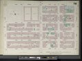
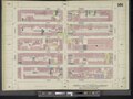
 Key NYPL2003132.tiff 6,658 × 8,886, 2 pages; 169.33 MB
-
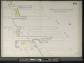
 Manhattan, V. 4, Double Page Plate No. 67 (Map bounded by E. 26th St., East River, E. 22nd St., 2nd Ave.) NYPL2003133.tiff 8,942 × 6,701, 2 pages; 171.49 MB
-
 Manhattan, V. 4, Double Page Plate No. 67 1-2 (Map bounded by East River, E. 22nd St., Avenue A) NYPL2003134.tiff 8,960 × 6,714, 2 pages; 172.17 MB
-
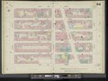
 Manhattan, V. 4, Double Page Plate No. 68 (Map bounded by E. 27th St., 2nd Ave., E. 22nd St., 4th Ave.) NYPL2003135.tiff 8,960 × 6,714, 2 pages; 172.17 MB
-

-
 Manhattan, V. 4, Double Page Plate No. 70 (Map bounded by E. 31st St., East River, E. 26th St., 2nd Ave.) NYPL2003137.tiff 8,847 × 6,629, 2 pages; 167.85 MB
-
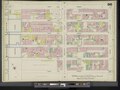
 Manhattan, V. 4, Double Page Plate No. 71 (Map bounded by E. 32nd St., 2nd Ave., E. 27th St., 4th Ave.) NYPL2003138.tiff 8,932 × 6,693, 2 pages; 171.1 MB
-

-
 Manhattan, V. 4, Double Page Plate No. 73 (Map bounded by 2nd Ave., E. 37th St., East River, E. 31st St.) NYPL2003140.tiff 8,954 × 6,710, 2 pages; 171.96 MB
-
 Manhattan, V. 4, Double Page Plate No. 74 (Map bounded by E. 37th St., 2nd Ave., E. 32nd St., 4th Ave.) NYPL2003141.tiff 8,953 × 6,708, 2 pages; 171.88 MB
-

-
 Manhattan, V. 4, Double Page Plate No. 76 (Map bounded by E. 42nd St., East River, E. 37th St., 2nd Ave.) NYPL2003143.tiff 8,969 × 6,721, 2 pages; 172.53 MB
-
 Manhattan, V. 4, Double Page Plate No. 77 (Map bounded by E. 42nd St., 2nd Ave., E. 37th St., Park Ave.) NYPL2003144.tiff 8,934 × 6,695, 2 pages; 171.19 MB
-
-
 Manhattan, V. 4, Double Page Plate No. 79 (Map bounded by E. 47th St., East River, E. 42nd St., 2nd Ave.) NYPL2003146.tiff 8,928 × 6,690, 2 pages; 170.95 MB
-
 Manhattan, V. 4, Double Page Plate No. 80 (Map bounded by E. 47th St., 2nd Ave., E. 42nd St., Vanderbilt Ave.) NYPL2003147.tiff 8,934 × 6,695, 2 pages; 171.19 MB
-

-
 Manhattan, V. 4, Double Page Plate No. 82 (Map bounded by E. 52nd St., East River, E. 47th St., 2nd Ave.) NYPL2003149.tiff 8,905 × 6,673, 2 pages; 170.07 MB
-
 Manhattan, V. 4, Double Page Plate No. 83 (Map bounded by E. 52nd St., 2nd Ave., E. 47th St., Park Ave.) NYPL2003150.tiff 8,918 × 6,683, 2 pages; 170.58 MB
-

-
 Manhattan, V. 5, Double Page Plate (Map bounded by Hudson River, 13th Ave., 12th Ave.) NYPL2001725.tiff 8,953 × 6,709, 2 pages; 171.91 MB
-
 Manhattan, V. 5, Double Page Plate No. 85 (Map bounded by W. 27th St., 6th Ave., W. 22nd St., 8th Ave.) NYPL2001707.tiff 8,977 × 6,727, 2 pages; 172.83 MB
-
 Manhattan, V. 5, Double Page Plate No. 86 (Map bounded by W. 27th St., 8th Ave., W. 22nd St., 10th Ave.) NYPL2001708.tiff 8,896 × 6,666, 2 pages; 169.72 MB
-
 Manhattan, V. 5, Double Page Plate No. 87 (Map bounded by W. 27th St., 10th Ave., W. 22nd St., Hudson River) NYPL2001709.tiff 8,870 × 6,646, 2 pages; 168.72 MB
-
 Manhattan, V. 5, Double Page Plate No. 88 (Map bounded by W. 32nd St., 6th Ave., W. 27th St., 8th Ave.) NYPL2001710.tiff 8,975 × 6,726, 2 pages; 172.77 MB
-
 Manhattan, V. 5, Double Page Plate No. 89 (Map bounded by W. 32nd St., 8th Ave., W. 27th St., 10th Ave.) NYPL2001711.tiff 8,963 × 6,716, 2 pages; 172.28 MB
-
 Manhattan, V. 5, Double Page Plate No. 90 (Map bounded by W. 32nd St., 10th Ave., W. 27th St., Hudson River) NYPL2001712.tiff 8,949 × 6,706, 2 pages; 171.76 MB
-
 Manhattan, V. 5, Double Page Plate No. 91 (Map bounded by W. 37th St., 6th Ave., W. 32nd St., 8th Ave.) NYPL2001713.tiff 8,935 × 6,695, 2 pages; 171.21 MB
-
 Manhattan, V. 5, Double Page Plate No. 92 (Map bounded by W. 37th St., 8th Ave., W. 32nd St., 10th Ave.) NYPL2001714.tiff 8,963 × 6,716, 2 pages; 172.28 MB
-
 Manhattan, V. 5, Double Page Plate No. 93 (Map bounded by W. 37th St., 10th Ave., W. 32nd St., Hudson River) NYPL2001715.tiff 8,902 × 6,670, 2 pages; 169.94 MB
-
 Manhattan, V. 5, Double Page Plate No. 94 (Map bounded by W. 42nd St., 6th Ave., W. 37th St., 8th Ave.) NYPL2001716.tiff 8,971 × 6,722, 2 pages; 172.59 MB
-
 Manhattan, V. 5, Double Page Plate No. 95 (Map bounded by W. 42nd St., 8th Ave., W. 37th St., 10th Ave.) NYPL2001717.tiff 8,971 × 6,722, 2 pages; 172.59 MB
-
 Manhattan, V. 5, Double Page Plate No. 96 (Map bounded by W. 42nd St., 10th Ave., W. 37th St., Hudson River) NYPL2001718.tiff 8,971 × 6,722, 2 pages; 172.59 MB
-
 Manhattan, V. 5, Double Page Plate No. 97 (Map bounded by W. 47th St., 6th Ave., W. 42nd St., 8th Ave.) NYPL2001719.tiff 8,956 × 6,711, 2 pages; 172.02 MB
-
 Manhattan, V. 5, Double Page Plate No. 98 (Map bounded by W. 47th St., 8th Ave., W. 42nd St., 10th Ave.) NYPL2001720.tiff 8,961 × 6,715, 2 pages; 172.22 MB
-
 Manhattan, V. 5, Double Page Plate No. 99 (Map bounded by W. 47th St., 10th Ave., W. 42nd St., Hudson River) NYPL2001721.tiff 8,971 × 6,722, 2 pages; 172.59 MB
-
 Manhattan, V. 5, Double Page Plate No. 100 (Map bounded by W. 52nd St., 6th Ave., W. 47th St., 8th Ave.) NYPL2001722.tiff 8,931 × 6,692, 2 pages; 171.05 MB
-
 Manhattan, V. 5, Double Page Plate No. 101 (Map bounded by W. 52nd St., 8th Ave., W. 47th St., 10th Ave.) NYPL2001723.tiff 8,953 × 6,709, 2 pages; 171.91 MB
-
 Manhattan, V. 5, Double Page Plate No. 102 (Map bounded by W. 52nd St., 10th Ave., W. 47th St., 12th Ave.) NYPL2001724.tiff 8,953 × 6,709, 2 pages; 171.91 MB