Category:TIF versions of Sanborn maps of Manhattan published in 1899
Jump to navigation
Jump to search
Maps from:
- Insurance Maps of the City of New York (Borough of Manhattan) Surveyed and Published by Sanborn–Perris Map Co., Limited. Volume 4. (New York: 1899), comprising 19 maps (18 double-page plates numbered 67–84 and one unnumbered single-page plate), title page, street index, and volume key.
- Insurance Maps of the City of New York (Borough of Manhattan) Surveyed and Published by Sanborn–Perris Map Co., Limited. Volume 5. (New York: 1899), comprising 18 maps (double-page plates) numbered 85–102 and one unnumbered double-page plate, title page, street index, and volume key.
Source: The New York Public Library Digital Collections website, Atlas 113. Vol. 4, 1899 and Atlas 116.01. Vol. 5, 1898 [sic].
Media in category "TIF versions of Sanborn maps of Manhattan published in 1899"
The following 44 files are in this category, out of 44 total.
-
 Index NYPL1990524.tiff 5,350 × 7,098, 2 pages; 108.71 MB
-

-
 Key NYPL1990526.tiff 5,350 × 7,098, 2 pages; 108.71 MB
-
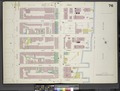
 Manhattan, V. 4, Double Page Plate No. 67 (Map bounded by East 26th St., Avenue A., East 22nd St., 2nd Ave.) NYPL1990527.tiff 7,203 × 5,405, 2 pages; 111.45 MB
-
 Manhattan, V. 4, Double Page Plate No. 68 (Map bounded by East 27th St., 2nd Ave., East 22nd St., 4th Ave.) NYPL1990528.tiff 7,127 × 5,365, 2 pages; 109.46 MB
-
 Manhattan, V. 4, Double Page Plate No. 69 (Map bounded by West 27th St., 4th Ave., West 22nd St., 6th Ave.) NYPL1990529.tiff 7,003 × 5,301, 2 pages; 106.27 MB
-
 Manhattan, V. 4, Double Page Plate No. 70 (Map bounded by East 31st St., East River, East 26th St., 2nd Ave.) NYPL1990530.tiff 7,003 × 5,301, 2 pages; 106.27 MB
-
 Manhattan, V. 4, Double Page Plate No. 71 (Map bounded by East 32nd St., 2nd Ave., East 27th st., 4th Ave.) NYPL1990531.tiff 7,003 × 5,301, 2 pages; 106.27 MB
-
 Manhattan, V. 4, Double Page Plate No. 72 (Map bounded by West 32nd St., 4th Ave., East 27th St., 6th Ave.) NYPL1990532.tiff 7,003 × 5,301, 2 pages; 106.27 MB
-
 Manhattan, V. 4, Double Page Plate No. 73 (Map bounded by 2nd Ave., East 37th St., East River, East 31st St.) NYPL1990533.tiff 7,024 × 5,312, 2 pages; 106.81 MB
-
 Manhattan, V. 4, Double Page Plate No. 74 (Map bounded by East 37th St., 2nd Ave., East 32nd St., Park Ave.) NYPL1990534.tiff 7,117 × 5,360, 2 pages; 109.2 MB
-

-
 Manhattan, V. 4, Double Page Plate No. 76 (Map bounded by East 42nd St., East River, East 37th St., 2nd Ave.) NYPL1990536.tiff 7,017 × 5,308, 2 pages; 106.62 MB
-
 Manhattan, V. 4, Double Page Plate No. 77 (Map bounded by East 42nd St., 2nd Ave., East 37th St., Park Ave.) NYPL1990537.tiff 7,119 × 5,362, 2 pages; 109.27 MB
-

-
 Manhattan, V. 4, Double Page Plate No. 79 (Map bounded by East 47th St., East River, East 42nd St., 2nd Ave.) NYPL1990539.tiff 7,163 × 5,384, 2 pages; 110.4 MB
-
 Manhattan, V. 4, Double Page Plate No. 80 (Map bounded by East 47th St., 2nd Ave., East 42nd St., Vanderbilt Ave.) NYPL1990540.tiff 7,143 × 5,374, 2 pages; 109.89 MB
-

-
 Manhattan, V. 4, Double Page Plate No. 82 (Map bounded by East 52nd St., East River, East 47th St., 2nd Ave.) NYPL1990542.tiff 7,143 × 5,374, 2 pages; 109.89 MB
-
 Manhattan, V. 4, Double Page Plate No. 83 (Map bounded by East 52nd St., 2nd Ave., East 47th St., Park Ave.) NYPL1990543.tiff 7,192 × 5,400, 2 pages; 111.17 MB
-

-

-

-
 Index NYPL1998908.tiff 5,407 × 7,209, 2 pages; 111.58 MB
-
 Key NYPL1998910.tiff 5,407 × 7,209, 2 pages; 111.58 MB
-
 Manhattan, V. 5, Double Page Plate (Hudson River piers) (Map bounded by Hudson River, 12th Ave; Hudson River 13th Ave.) NYPL1998929.tiff 8,952 × 6,708, 2 pages; 171.87 MB
-
 Manhattan, V. 5, Double Page Plate No. 85 (Map bounded by West 27th St., 6th Ave., West 22nd St., 8th Ave.) NYPL1998911.tiff 8,960 × 6,714, 2 pages; 172.17 MB
-
 Manhattan, V. 5, Double Page Plate No. 86 (Map bounded by West 27th St., 8th Ave., West 22nd St., 10th Ave.) NYPL1998912.tiff 8,939 × 6,699, 2 pages; 171.39 MB
-
 Manhattan, V. 5, Double Page Plate No. 87 (Map bounded by West 27th St., 10th Ave., West 22nd St., Hudson River.) NYPL1998913.tiff 8,979 × 6,728, 2 pages; 172.9 MB
-
 Manhattan, V. 5, Double Page Plate No. 88 (Map bounded by West 32nd St., 6th Ave., West 27th St., 8th Ave.) NYPL1998914.tiff 8,979 × 6,728, 2 pages; 172.9 MB
-
 Manhattan, V. 5, Double Page Plate No. 89 (Map bounded by West 32nd St., 8th Ave., West 27th St., 10th Ave.) NYPL1998915.tiff 8,979 × 6,728, 2 pages; 172.9 MB
-
 Manhattan, V. 5, Double Page Plate No. 90 (Map bounded by West 32nd St., 10th Ave., West 27th St., 13th Ave.) NYPL1998916.tiff 8,959 × 6,714, 2 pages; 172.15 MB
-
 Manhattan, V. 5, Double Page Plate No. 91 (Map bounded by West 37th St., 6th Ave., West 32nd St., 8th Ave.) NYPL1998917.tiff 8,959 × 6,714, 2 pages; 172.15 MB
-
 Manhattan, V. 5, Double Page Plate No. 92 (Map bounded by West 37th St., 8th Ave., West 32nd St., 10th Ave.) NYPL1998918.tiff 8,898 × 6,667, 2 pages; 169.79 MB
-
 Manhattan, V. 5, Double Page Plate No. 93 (Map bounded by West 37th St., 10th Ave., West 32nd St., 12th Ave.) NYPL1998919.tiff 8,898 × 6,667, 2 pages; 169.79 MB
-
 Manhattan, V. 5, Double Page Plate No. 94 (Map bounded by West 42nd St., 6th Ave., West 37th St., 8th Ave.) NYPL1998920.tiff 8,941 × 6,700, 2 pages; 171.45 MB
-
 Manhattan, V. 5, Double Page Plate No. 95 (Map bounded by West 42nd St., 8th Ave., West 37th St., 10th Ave.) NYPL1998921.tiff 8,941 × 6,700, 2 pages; 171.45 MB
-
 Manhattan, V. 5, Double Page Plate No. 96 (Map bounded by West 42nd St., 10th Ave., West 37th St., 12th Ave.) NYPL1998922.tiff 8,926 × 6,689, 2 pages; 170.88 MB
-
 Manhattan, V. 5, Double Page Plate No. 97 (Map bounded by West 47th St., 6th Ave., West 42nd St., 8th Ave.) NYPL1998923.tiff 8,950 × 6,706, 2 pages; 171.78 MB
-
 Manhattan, V. 5, Double Page Plate No. 98 (Map bounded by West 47th St., 8th Ave., West 42nd St., 10th Ave.) NYPL1998924.tiff 8,967 × 6,719, 2 pages; 172.44 MB
-
 Manhattan, V. 5, Double Page Plate No. 99 (Map bounded by West 47th St., 10th Ave., West 42nd St., 12th Ave.) NYPL1998925.tiff 8,967 × 6,719, 2 pages; 172.44 MB
-
 Manhattan, V. 5, Double Page Plate No. 100 (Map bounded by West 52nd St., 6th Ave., West 47th St., 8th Ave.) NYPL1998926.tiff 8,967 × 6,719, 2 pages; 172.44 MB
-
 Manhattan, V. 5, Double Page Plate No. 101 (Map bounded by West 52nd St., 8th Ave., West 47th St., 10th Ave.) NYPL1998927.tiff 8,963 × 6,716, 2 pages; 172.28 MB
-
 Manhattan, V. 5, Double Page Plate No. 102 (Map bounded by West 52nd St., 10th Ave., West 47th St., 12th Ave.) NYPL1998928.tiff 8,952 × 6,708, 2 pages; 171.87 MB