Category:TIF versions of Sanborn maps of Manhattan published in 1907
Jump to navigation
Jump to search
Maps from: Insurance Maps of the City of New York Borough of Manhattan. Volume Six. (New York: Sanborn Map Company, 1907), comprising 77 plates (maps) plus street index, title page, and volume key (the last one missing from this category).
Online at The New York Public Library Digital Collections website, Atlas 118. Vol. 6, 1907.
Media in category "TIF versions of Sanborn maps of Manhattan published in 1907"
The following 79 files are in this category, out of 79 total.
-
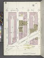
 Index NYPL1993932.tiff 5,340 × 7,078, 2 pages; 108.2 MB
-

-
 Manhattan, V. 6, Plate No. 1 (Map bounded by Hudson River, W. 55th St., 11th Ave., W. 52nd St.) NYPL1993934.tiff 5,367 × 7,129, 2 pages; 109.53 MB
-
 Manhattan, V. 6, Plate No. 2 (Map bounded by Hudson River, W. 58th St., 11th Ave., W. 55th St.) NYPL1993935.tiff 5,385 × 7,164, 2 pages; 110.43 MB
-
 Manhattan, V. 6, Plate No. 3 (Map bounded by Hudson River, 11th Ave., W. 58th St.) NYPL1993936.tiff 5,367 × 7,129, 2 pages; 109.53 MB
-
 Manhattan, V. 6, Plate No. 4 (Map bounded by Hudson River, W. End Ave.) NYPL1993937.tiff 5,385 × 7,164, 2 pages; 110.43 MB
-
 Manhattan, V. 6, Plate No. 5 (Map bounded by Hudson River, W. 67th St., W. End Ave., W. 64th St.) NYPL1993938.tiff 5,367 × 7,129, 2 pages; 109.53 MB
-
 Manhattan, V. 6, Plate No. 6 (Map bounded by Hudson River, W. 70th St., W. End Ave., W. 67th St.) NYPL1993939.tiff 5,385 × 7,164, 2 pages; 110.43 MB
-
 Manhattan, V. 6, Plate No. 7 (Map bounded by 11th Ave., W. 55th St., 10th Ave., W. 52nd St.) NYPL1993940.tiff 5,367 × 7,129, 2 pages; 109.53 MB
-
 Manhattan, V. 6, Plate No. 8 (Map bounded by 11th Ave., W. 58th St., 10th Ave., W. 55th St.) NYPL1993941.tiff 5,385 × 7,164, 2 pages; 110.43 MB
-
 Manhattan, V. 6, Plate No. 9 (Map bounded by 11th Ave., W. 61st St., 10th Ave., W. 58th St.) NYPL1993942.tiff 5,367 × 7,129, 2 pages; 109.53 MB
-
 Manhattan, V. 6, Plate No. 10 (Map bounded by W. End Ave., W. 64th St., Amsterdam Ave., W. 61st St.) NYPL1993943.tiff 5,385 × 7,164, 2 pages; 110.43 MB
-
 Manhattan, V. 6, Plate No. 11 (Map bounded by W. End Ave., W. 67th St., Amsterdam Ave., W. 64th St.) NYPL1993944.tiff 5,367 × 7,129, 2 pages; 109.53 MB
-
 Manhattan, V. 6, Plate No. 12 (Map bounded by W. End Ave., W. 70th St., Amsterdam Ave., W. 67th St.) NYPL1993945.tiff 5,385 × 7,164, 2 pages; 110.43 MB
-
 Manhattan, V. 6, Plate No. 13 (Map bounded by Hudson River, W. End Ave., W. 70th St.) NYPL1993946.tiff 5,367 × 7,129, 2 pages; 109.53 MB
-
 Manhattan, V. 6, Plate No. 14 (Map bounded by W. End Ave., W. 72nd St., Broadway, W. 70th St.) NYPL1993947.tiff 5,385 × 7,164, 2 pages; 110.43 MB
-
 Manhattan, V. 6, Plate No. 15 (Map bounded by 10th Ave., W. 55th St., 9th Ave., W. 52nd St.) NYPL1993948.tiff 5,367 × 7,129, 2 pages; 109.53 MB
-
 Manhattan, V. 6, Plate No. 16 (Map bounded by 10th Ave., W. 58th St., 9th Ave., W. 55th St.) NYPL1993949.tiff 5,385 × 7,164, 2 pages; 110.43 MB
-
 Manhattan, V. 6, Plate No. 17 (Map bounded by 10th Ave., W. 61st St., 9th Ave., W. 58th St.) NYPL1993950.tiff 5,367 × 7,129, 2 pages; 109.53 MB
-
 Manhattan, V. 6, Plate No. 18 (Map bounded by Amsterdam Ave., W. 64th St., Columbus Ave., W. 61st St.) NYPL1993951.tiff 5,385 × 7,164, 2 pages; 110.43 MB
-
 Manhattan, V. 6, Plate No. 19 (Map bounded by Amsterdam Ave., W. 67th St., Columbus Ave., W. 64th St.) NYPL1993952.tiff 5,367 × 7,129, 2 pages; 109.53 MB
-
 Manhattan, V. 6, Plate No. 20 (Map bounded by Amsterdam Ave., W. 70th St., Columbus Ave., W. 67th St.) NYPL1993953.tiff 5,385 × 7,164, 2 pages; 110.43 MB
-
 Manhattan, V. 6, Plate No. 21 (Map bounded by 9th Ave., W. 55th St., 8th Ave., W. 52nd St.) NYPL1993954.tiff 5,367 × 7,129, 2 pages; 109.53 MB
-
 Manhattan, V. 6, Plate No. 22 (Map bounded by 9th Ave., W. 58th St., 8th Ave., W. 55th St.) NYPL1993955.tiff 5,385 × 7,164, 2 pages; 110.43 MB
-
 Manhattan, V. 6, Plate No. 23 (Map bounded by 9th Ave., W. 61st St., 8th Ave., W. 58th St.) NYPL1993956.tiff 5,368 × 7,132, 2 pages; 109.59 MB
-
 Manhattan, V. 6, Plate No. 24 (Map bounded by Columbus Ave., W. 64th St., Central Park West, W. 61st St.) NYPL1993957.tiff 5,385 × 7,164, 2 pages; 110.43 MB
-
 Manhattan, V. 6, Plate No. 25 (Map bounded by Columbus Ave., W. 67th St., Central Park West, W. 64th St.) NYPL1993958.tiff 5,380 × 7,155, 2 pages; 110.19 MB
-
 Manhattan, V. 6, Plate No. 26 (Map bounded by Columbus Ave., W. 70th St., Central Park West, W. 67th St.) NYPL1993959.tiff 5,385 × 7,164, 2 pages; 110.43 MB
-
 Manhattan, V. 6, Plate No. 27 (Map bounded by Amsterdam Ave., W. 72nd St., Columbus Ave., W. 70th St.) NYPL1993960.tiff 5,380 × 7,155, 2 pages; 110.19 MB
-
 Manhattan, V. 6, Plate No. 28 (Map bounded by Columbus Ave., W. 72nd St., Central Park West, W. 70th St.) NYPL1993961.tiff 5,362 × 7,120, 2 pages; 109.29 MB
-
 Manhattan, V. 6, Plate No. 29 (Map bounded by 8th Ave., W. 55th St., 7th Ave., W. 52nd St.) NYPL1993962.tiff 5,380 × 7,155, 2 pages; 110.19 MB
-
 Manhattan, V. 6, Plate No. 30 (Map bounded by 8th Ave., W. 58th St., 7th Ave., W. 55th St.) NYPL1993963.tiff 5,362 × 7,120, 2 pages; 109.29 MB
-
 Manhattan, V. 6, Plate No. 31 (Map bounded by 7th Ave., W. 55th St., 6th Ave., W. 52nd St.) NYPL1993964.tiff 5,380 × 7,155, 2 pages; 110.19 MB
-
 Manhattan, V. 6, Plate No. 32 (Map bounded by 7th Ave., W. 58th St., 6th Ave., W. 55th St.) NYPL1993965.tiff 5,362 × 7,120, 2 pages; 109.29 MB
-
 Manhattan, V. 6, Plate No. 33 (Map bounded by 6th Ave., W. 55th St., 5th Ave., W. 52nd St.) NYPL1993966.tiff 5,380 × 7,155, 2 pages; 110.19 MB
-
 Manhattan, V. 6, Plate No. 34 (Map bounded by 6th Ave., W. 58th St., 5th Ave., W. 55th St.) NYPL1993967.tiff 5,362 × 7,120, 2 pages; 109.29 MB
-
 Manhattan, V. 6, Plate No. 35 (Map bounded by 8th Ave., Central Park South, 7th Ave., W. 58th St.) NYPL1993968.tiff 5,380 × 7,155, 2 pages; 110.19 MB
-
 Manhattan, V. 6, Plate No. 36 (Map bounded by 6th Ave., Central Park South, 5th Ave., W. 58th St.) NYPL1993969.tiff 5,362 × 7,120, 2 pages; 109.29 MB
-
 Manhattan, V. 6, Plate No. 37 (Map bounded by 5th Ave., E. 55th St., Park Ave., E. 52nd St.) NYPL1993970.tiff 5,380 × 7,155, 2 pages; 110.19 MB
-
 Manhattan, V. 6, Plate No. 38 (Map bounded by 5th Ave., E. 58th St., Park Ave., E. 55th St.) NYPL1993971.tiff 5,362 × 7,120, 2 pages; 109.29 MB
-
 Manhattan, V. 6, Plate No. 39 (Map bounded by 5th Ave., E. 61st St., Park Ave., E. 58th St.) NYPL1993972.tiff 5,380 × 7,155, 2 pages; 110.19 MB
-
 Manhattan, V. 6, Plate No. 40 (Map bounded by 5th Ave., E. 64th St., Park Ave., E. 61st St.) NYPL1993973.tiff 5,362 × 7,120, 2 pages; 109.29 MB
-
 Manhattan, V. 6, Plate No. 41 (Map bounded by 5th Ave., E. 67th St., Park Ave., E. 64th St.) NYPL1993974.tiff 5,380 × 7,155, 2 pages; 110.19 MB
-
 Manhattan, V. 6, Plate No. 42 (Map bounded by 5th Ave., E. 70th St., Park Ave., E. 67th St.) NYPL1993975.tiff 5,362 × 7,120, 2 pages; 109.29 MB
-
 Manhattan, V. 6, Plate No. 43 (Map bounded by Park Ave., E. 55th St., 3rd Ave., E. 52nd St.) NYPL1993976.tiff 5,380 × 7,155, 2 pages; 110.19 MB
-
 Manhattan, V. 6, Plate No. 44 (Map bounded by Park Ave., E. 58th St., 3rd Ave., E. 55th St.) NYPL1993977.tiff 5,362 × 7,120, 2 pages; 109.29 MB
-
 Manhattan, V. 6, Plate No. 45 (Map bounded by Park Ave., E. 61st St., 3rd Ave., E. 58th St.) NYPL1993978.tiff 5,380 × 7,155, 2 pages; 110.19 MB
-
 Manhattan, V. 6, Plate No. 46 (Map bounded by Park Ave., E. 64th St., 3rd Ave., E. 61st St.) NYPL1993979.tiff 5,362 × 7,120, 2 pages; 109.29 MB
-
 Manhattan, V. 6, Plate No. 47 (Map bounded by Park Ave., E. 67th St., 3rd Ave., E. 64th St.) NYPL1993980.tiff 5,380 × 7,155, 2 pages; 110.19 MB
-
 Manhattan, V. 6, Plate No. 48 (Map bounded by Park Ave., E. 70th St., 3rd Ave., E. 67th St.) NYPL1993981.tiff 5,362 × 7,120, 2 pages; 109.29 MB
-
 Manhattan, V. 6, Plate No. 49 (Map bounded by 5th Ave., E. 72nd St., Park Ave., 70th St.) NYPL1993982.tiff 5,394 × 7,182, 2 pages; 110.9 MB
-
 Manhattan, V. 6, Plate No. 50 (Map bounded by Park Ave., E. 72nd St., 3rd Ave., E. 70th St.) NYPL1993983.tiff 5,362 × 7,120, 2 pages; 109.29 MB
-
 Manhattan, V. 6, Plate No. 51 (Map bounded by E. 56th St., 2nd Ave., E. 52nd St., 3rd Ave.) NYPL1993984.tiff 5,394 × 7,182, 2 pages; 110.9 MB
-
 Manhattan, V. 6, Plate No. 52 (Map bounded by E. 56th St., 1st Ave., E. 52nd St., 2nd Ave.) NYPL1993985.tiff 5,362 × 7,120, 2 pages; 109.29 MB
-
 Manhattan, V. 6, Plate No. 53 (Map bounded by E. 60th St., 2nd Ave., E. 56th St., 3rd Ave.) NYPL1993986.tiff 5,408 × 7,208, 2 pages; 111.59 MB
-
 Manhattan, V. 6, Plate No. 54 (Map bounded by E. 60th St., 1st Ave., E. 56th St., 2nd Ave.) NYPL1993987.tiff 5,362 × 7,120, 2 pages; 109.29 MB
-
 Manhattan, V. 6, Plate No. 55 (Map bounded by E. 64th St., 2nd Ave., E. 60th St., 3rd Ave.) NYPL1993988.tiff 5,403 × 7,199, 2 pages; 111.34 MB
-
 Manhattan, V. 6, Plate No. 56 (Map bounded by E. 64th St., 1st Ave., E. 60th St., 2nd Ave.) NYPL1993989.tiff 5,362 × 7,120, 2 pages; 109.29 MB
-
 Manhattan, V. 6, Plate No. 57 (Map bounded by E. 68th St., 2nd Ave., E. 64th St., 3rd Ave.) NYPL1993990.tiff 5,403 × 7,199, 2 pages; 111.34 MB
-
 Manhattan, V. 6, Plate No. 58 (Map bounded by E. 68th St., 1st Ave., E. 64th St., 2nd Ave.) NYPL1993991.tiff 5,362 × 7,120, 2 pages; 109.29 MB
-
 Manhattan, V. 6, Plate No. 59 (Map bounded by E. 72nd St., 2nd Ave., E. 68th St., 3rd Ave.) NYPL1993992.tiff 5,403 × 7,199, 2 pages; 111.34 MB
-
 Manhattan, V. 6, Plate No. 60 (Map bounded by E. 72nd St., 1st Ave., E. 68th St., 2nd Ave.) NYPL1993993.tiff 5,362 × 7,120, 2 pages; 109.29 MB
-
 Manhattan, V. 6, Plate No. 61 (Map bounded by E. 56th St., Avenue A, E. 52nd St., 1st Ave.) NYPL1993994.tiff 5,403 × 7,199, 2 pages; 111.34 MB
-
 Manhattan, V. 6, Plate No. 62 (Map bounded by E. 60th St., Avenue A, E. 56th St., 1st Ave.) NYPL1993995.tiff 5,362 × 7,120, 2 pages; 109.29 MB
-
 Manhattan, V. 6, Plate No. 63 (Map bounded by E. 64th St., Avenue A, E. 60th St., 1st Ave.) NYPL1993996.tiff 5,403 × 7,199, 2 pages; 111.34 MB
-
 Manhattan, V. 6, Plate No. 64 (Map bounded by E. 64th St., East River, Avenue A) NYPL1993997.tiff 5,362 × 7,120, 2 pages; 109.29 MB
-
 Manhattan, V. 6, Plate No. 65 (Map bounded by E. 68th St., Avenue A, E. 64th St., 1st Ave.) NYPL1993998.tiff 5,403 × 7,199, 2 pages; 111.34 MB
-
 Manhattan, V. 6, Plate No. 66 (Map bounded by E. 68th St., East River, E. 64th St., Avenue A) NYPL1993999.tiff 5,362 × 7,120, 2 pages; 109.29 MB
-
 Manhattan, V. 6, Plate No. 67 (Map bounded by E. 72nd St., Avenue A, E. 68th St., 1st Ave.) NYPL1994000.tiff 5,403 × 7,199, 2 pages; 111.34 MB
-
 Manhattan, V. 6, Plate No. 68 (Map bounded by E. 72nd St., East River, E. 68th St., Avenue A) NYPL1994001.tiff 5,362 × 7,120, 2 pages; 109.29 MB
-
 Manhattan, V. 6, Plate No. 69 (Map bounded by E. 56th St., East River, E. 52nd St., Avenue A, E. 60th St.) NYPL1994002.tiff 5,403 × 7,199, 2 pages; 111.34 MB
-
 Manhattan, V. 6, Plate No. 70 (Map bounded by 5th Ave., Central Park South, Central Park West) NYPL1994003.tiff 5,362 × 7,120, 2 pages; 109.29 MB
-
 Manhattan, V. 6, Plate No. 71 (Map bounded by Hudson River, 12th Ave.) NYPL1994004.tiff 5,403 × 7,199, 2 pages; 111.34 MB
-
 Manhattan, V. 6, Plate No. 72 (Map bounded by Hudson River, 12th Ave.) NYPL1994005.tiff 5,362 × 7,120, 2 pages; 109.29 MB
-
 Manhattan, V. 6, Plate No. 73 (Map bounded by Hudson River, 12th Ave.) NYPL1994006.tiff 5,403 × 7,199, 2 pages; 111.34 MB
-
 Manhattan, V. 6, Plate No. 74 (Map bounded by Hudson River) NYPL1994007.tiff 5,385 × 7,164, 2 pages; 110.43 MB
-
 Manhattan, V. 6, Plate No. 75 (Map bounded by Hudson River) NYPL1994008.tiff 5,403 × 7,199, 2 pages; 111.34 MB
-
 Manhattan, V. 6, Plate No. 76 (Map bounded by Hudson River) NYPL1994009.tiff 5,385 × 7,164, 2 pages; 110.43 MB
-
 Manhattan, V. 6, Plate No. 77 (Map bounded by Hudson River) NYPL1994010.tiff 5,403 × 7,199, 2 pages; 111.34 MB