Category:Tafahi
Jump to navigation
Jump to search
island of the Tonga archipelago   | |||||
| Upload media | |||||
| Instance of | |||||
|---|---|---|---|---|---|
| Part of | |||||
| Location | Niuas, Niua district | ||||
| Located in or next to body of water | |||||
| Width |
| ||||
| Length |
| ||||
| Topographic prominence |
| ||||
| Population |
| ||||
| Area |
| ||||
| Elevation above sea level |
| ||||
 | |||||
Media in category "Tafahi"
The following 17 files are in this category, out of 17 total.
-
 1619 Schouten map close-up (Niuas, Futuna and Alofi islands).jpg 796 × 462; 200 KB
-

-
 AMH-8123-KB View of Cocos Island and Traitors' Island.jpg 1,992 × 2,400; 840 KB
-

-

-
 Hessel Gerritsz 1622 map of the Pacific - closeup 'Illas de Salomon'.png 1,203 × 605; 1.63 MB
-

-
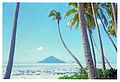 Hihifo, 1969. Tafahi from Niuatoputapu.jpg 2,256 × 1,539; 574 KB
-
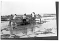 Launching a book ashore in Tafahi (Tonga).jpg 9,998 × 6,824; 5.85 MB
-
 Niuas Banner.jpg 8,315 × 1,188; 1.18 MB
-
 Niuatoputapu group.jpg 3,060 × 2,032; 1.06 MB
-
 Nz8215 open sea chart Niuatoputapu Niuafo'ou.tif 8,112 × 6,083; 2.37 MB
-
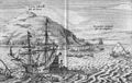
 Samuel Wallis map of Boscawen and Keppel islands (Tafahi and Niuatoputapu).jpg 2,339 × 2,464; 2.51 MB
-

-
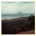 Tafahi and Vaipoa village from central ridge.jpg 9,999 × 9,999; 5.3 MB
-
 TAFAHI, Tonga (2023-10-31-09-00-57 UMBRA-04).tiff 27,122 × 33,285, 8 pages; 1.15 GB
-
 View of Cocos Island and Traitors' Island (better quality).jpg 2,568 × 1,626; 3.19 MB
.jpg)


.jpg)
.jpg)


.jpg)

.jpg)
_from_the_summit_of_Tafahi.jpg)

.jpg)