Category:Tasmania in the 1970s
Jump to navigation
Jump to search
Wikimedia category | |||||
| Upload media | |||||
| Instance of | |||||
|---|---|---|---|---|---|
| Category combines topics | |||||
| Tasmania | |||||
state of Australia     | |||||
| Pronunciation audio | |||||
| Instance of |
| ||||
| Part of | |||||
| Named after | |||||
| Location | AUS | ||||
| Capital | |||||
| Legislative body | |||||
| Executive body | |||||
| Highest judicial authority | |||||
| Head of state |
| ||||
| Head of government |
| ||||
| Inception |
| ||||
| Highest point | |||||
| Population |
| ||||
| Area |
| ||||
| Elevation above sea level |
| ||||
| Replaces |
| ||||
| Different from | |||||
| official website | |||||
 | |||||
Subcategories
This category has the following 12 subcategories, out of 12 total.
- 1972 in Tasmania (8 F)
- 1973 in Tasmania (4 F)
- 1974 in Tasmania (17 F)
- 1976 in Tasmania (7 F)
- 1979 in Tasmania (1 F)
H
Media in category "Tasmania in the 1970s"
The following 26 files are in this category, out of 26 total.
-
 Clark River between Mount Darwin and Mount Sorell in Western Tasmania in the 1970s.jpg 4,128 × 2,720; 1.35 MB
-
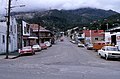 Cutten Street Queenstown, Tasmania in the 1970s.jpg 4,112 × 2,704; 1,021 KB
-
 Eastern part of Mount Sedgwick, Tasmania.jpg 4,048 × 2,736; 1.14 MB
-
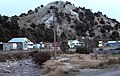 Hill in Queenstown Tasmania in the 1970s.jpg 4,048 × 2,576; 1,005 KB
-
 Hydro sign on or near Kelly Basin road in the 1970s.jpg 4,048 × 2,576; 1.14 MB
-
 Hydro track down to the Franklin in the 1970s.jpg 2,736 × 4,048; 880 KB
-
 Kelly Basin Road 1970s.jpg 5,420 × 2,453; 2.12 MB
-
 Lyell Highway after Derwent Bridge with snow.jpg 4,128 × 2,736; 930 KB
-
 Lyell Highway between Derwent Bridge and Mount King William after snow storm.jpg 3,334 × 1,759; 187 KB
-
 Mount Anne area - Lot's Wife from Mt Sarah Jane.jpg 1,612 × 1,088; 406 KB
-
 Mount Huxley from east before Lake Burbury.jpg 1,581 × 690; 510 KB
-
 Mount Jukes from West.jpg 1,573 × 558; 1.72 MB
-
 Mount Lyell era sign on or near Kelly basin road in 1970s.jpg 4,144 × 2,576; 1.04 MB
-
 Mount Lyell lease stumps 1970s.jpg 1,799 × 1,199; 664 KB
-
 Mount Owen north west waterfall near the Lyell highway.jpg 3,443 × 2,111; 698 KB
-
 Mt McCall track from the air in the 1970s.jpg 4,176 × 2,720; 842 KB
-
 Peak of Sedgwick, 1970s.jpg 1,226 × 437; 875 KB
-
 Pink conglomerate of Mount Owen.jpg 1,596 × 1,080; 931 KB
-
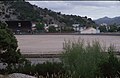
 Queen River in the 1970s.jpg 3,973 × 2,736; 1.15 MB
-
 Queenstown football oval in the 1970s.jpg 4,176 × 2,720; 1,009 KB
-
 Snow on the western slope of the Tyndall range in Western Tasmania in the 1970s.tif 1,612 × 1,020; 4.71 MB
-
 Starting up the hill out of Queenstown on a rainy day.jpg 4,112 × 2,704; 641 KB
-
 State Cinema renovations - Elizabeth St, North Hobart (c1970).jpg 3,508 × 2,451; 3.31 MB
-
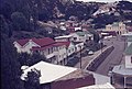 Sticht Street Queenstown, Tasmania from Spion Kop in 1970s.jpg 4,048 × 2,720; 1.09 MB
-
 Tyndalls from the west 1970s.jpg 1,332 × 411; 542 KB
-


.jpg)

_arriving_at_Hobart,_Tasmania,_Australia,_on_4_May_1978.jpg)