Category:Te Reinga Falls
Jump to navigation
Jump to search
| Object location | | View all coordinates using: OpenStreetMap |
|---|
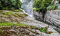
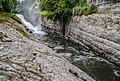
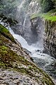
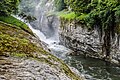
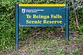
four waterfalls in the area of the village of Te Reinga in the Hawke's Bay region on the North Island of New Zealand  | |||||
| Upload media | |||||
| Instance of | |||||
|---|---|---|---|---|---|
| Location | Wairoa District, Hawke's Bay Region, New Zealand | ||||
 | |||||
Media in category "Te Reinga Falls"
The following 18 files are in this category, out of 18 total.
-
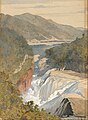 J. C. Richmond - Te Reinga, Falls of the Wairoa. Hawke's Bay - Google Art Project.jpg 3,649 × 4,981; 4.84 MB
-
 Te Reinga Falls 01.jpg 3,940 × 2,627; 9.23 MB
-
 Te Reinga Falls 02.jpg 3,556 × 5,669; 14 MB
-
 Te Reinga Falls 03.jpg 4,469 × 2,979; 11 MB
-
 Te Reinga Falls 04.jpg 5,625 × 3,763; 18.05 MB
-
 Te Reinga Falls 05.jpg 5,808 × 3,872; 19.16 MB
-
 Te Reinga Falls 06.jpg 4,471 × 3,066; 13.38 MB
-
 Te Reinga Falls 07.jpg 4,963 × 3,002; 14.97 MB
-
 Te Reinga Falls 08.jpg 4,000 × 6,000; 18.84 MB
-
 Te Reinga Falls 09.jpg 4,128 × 2,752; 10.09 MB
-
 Te Reinga Falls 10.jpg 5,832 × 3,888; 15.04 MB
-
 Te Reinga Falls 11.jpg 6,000 × 4,000; 19.64 MB
-
 Te Reinga Falls 12.jpg 4,224 × 2,816; 7.96 MB
-
 Te Reinga Falls 13.jpg 2,819 × 4,228; 8.88 MB
-
 Te Reinga Falls 14.jpg 3,894 × 2,630; 9.23 MB
-
 Te Reinga Falls 15.jpg 2,707 × 4,061; 9.28 MB
-
 Te Reinga Falls 16.jpg 4,260 × 2,840; 12.23 MB
-
 Te Reinga Falls 17.jpg 4,260 × 2,840; 11.41 MB


