Category:Teisendorf
Jump to navigation
Jump to search
market municipality of Germany    | |||||
| Upload media | |||||
| Instance of |
| ||||
|---|---|---|---|---|---|
| Part of |
| ||||
| Location | Berchtesgadener Land, Upper Bavaria, Bavaria, Germany | ||||
| Population |
| ||||
| Area |
| ||||
| Elevation above sea level |
| ||||
| official website | |||||
 | |||||
Subcategories
This category has the following 5 subcategories, out of 5 total.
!
B
H
Media in category "Teisendorf"
The following 26 files are in this category, out of 26 total.
-
 DEU Teisendorf COA.svg 696 × 754; 186 KB
-
 Wappen von Teisendorf.png 185 × 199; 11 KB
-
 AK - Teisendorf - 1901.jpg 1,576 × 2,120; 1.78 MB
-
 AK - Teisendorf mit Staufen - 1914.jpg 1,600 × 2,090; 2.97 MB
-
 AK - Teisendorf mit Untersberg - 1923.jpg 1,504 × 1,957; 2.07 MB
-
 Oberteisendorfer Ache.jpg 4,096 × 2,304; 2.17 MB
-
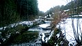
 Ramsauer Bach.jpg 4,096 × 2,304; 1.74 MB
-
 Salzstraße Beschilderung.jpg 1,536 × 2,048; 753 KB
-
 Siegelmarke Markt Teisendorf Bayern W0391164.jpg 267 × 270; 13 KB
-
 Teisendorf - Gumperding - Motiv - 2022 01 15-1.jpg 4,628 × 3,085; 1.16 MB
-
 Teisendorf - Stötten - Motiv - 2022 01 15-1.jpg 5,184 × 3,456; 3.22 MB
-
 Teisendorf 2.jpg 4,272 × 2,848; 2.28 MB
-
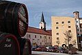 Teisendorf Brauerei.jpg 4,272 × 2,848; 1.66 MB
-
 Teisendorf in BGL.png 293 × 419; 8 KB
-
 Teisendorf Marktstraße 1.jpg 4,272 × 2,848; 2.05 MB
-
 Teisendorf Marktstraße 2.jpg 2,848 × 4,272; 2.09 MB
-
 TEISENDORF NEUKIRCHEN nieder.png 480 × 360; 5 KB
-
 TEISENDORF NEUKIRCHEN nieder.svg 512 × 427; 21 KB
-
 TEISENDORF nieder.png 480 × 360; 5 KB
-
 TEISENDORF nieder.svg 512 × 427; 21 KB
-
 Teisendorf vom Zug, Hochstaufen 2015-07 (2).jpg 3,221 × 2,377; 3.98 MB
-
 Teisendorf vom Zug, Hochstaufen, Teisenberg 2015-07 (3).jpg 3,495 × 2,359; 3.69 MB
-
 Teisendorf, BGL - Marktstr v W.jpg 4,000 × 2,248; 2.11 MB
-
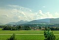
 Teisendorf, BGL - Surbergbichl - Rauschberg.jpg 4,000 × 2,248; 2.18 MB
-
 Teisendorf, BGL v NW, BGL 12, Högl.jpg 3,907 × 2,152; 855 KB
-
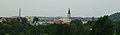 Teisendorf.jpg 2,048 × 600; 246 KB


.jpg)
.jpg)


