Category:Terraced houses in Bramley, Leeds
Jump to navigation
Jump to search
Media in category "Terraced houses in Bramley, Leeds"
The following 43 files are in this category, out of 43 total.
-
 Aston Road end of houses on Highfield Road - geograph.org.uk - 5899766.jpg 1,024 × 685; 152 KB
-
 Back Lane, Bramley, Leeds - geograph.org.uk - 4927334.jpg 1,280 × 805; 771 KB
-
 Back Melbourne Grove, Bramley, Leeds - geograph.org.uk - 5665934.jpg 1,280 × 853; 635 KB
-
 Back Melbourne Grove, Bramley, Leeds - geograph.org.uk - 5665935.jpg 1,280 × 719; 428 KB
-
 Back Raynville Terrace, Bramley - geograph.org.uk - 4970310.jpg 1,024 × 576; 153 KB
-
 Back, Melbourne Grove, Bramley, Leeds - geograph.org.uk - 5667633.jpg 1,280 × 762; 497 KB
-
 Back, Warrels Mount, Bramley, Leeds - geograph.org.uk - 5667594.jpg 1,280 × 669; 512 KB
-
 Backs of houses on Rossefield Grove, Bramley - geograph.org.uk - 4832391.jpg 1,024 × 768; 201 KB
-
 Backs of houses on Rossefield View, Bramley - geograph.org.uk - 4832394.jpg 1,024 × 768; 201 KB
-
 Bottom end of Raynville Crescent - geograph.org.uk - 4598805.jpg 1,024 × 768; 119 KB
-
 Bottom of Back Aston Road, Bramley - geograph.org.uk - 4598716.jpg 1,024 × 768; 116 KB
-
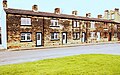
 Cottages, Back Lane, Bramley - geograph.org.uk - 6458851.jpg 1,024 × 768; 248 KB
-
 Elder Road, Bramley, Leeds - geograph.org.uk - 5674728.jpg 1,280 × 853; 678 KB
-
 Ferncliffe Terrace - Ferncliffe Road - geograph.org.uk - 1127408.jpg 640 × 442; 176 KB
-
 Ferncliffe Terrace, Bramley, Leeds - geograph.org.uk - 5667591.jpg 1,280 × 661; 439 KB
-
 Grosmont Place, Bramley, Leeds - geograph.org.uk - 5665901.jpg 1,280 × 853; 639 KB
-
 Grosmont Place, Bramley, Leeds - geograph.org.uk - 5665904.jpg 1,280 × 809; 569 KB
-
 Grosmont Road, Bramley, Leeds - geograph.org.uk - 5667610.jpg 1,280 × 672; 493 KB
-
 Grosmont Terrace, Bramley, Leeds - geograph.org.uk - 5665909.jpg 1,280 × 668; 528 KB
-
 Grosmont Terrace, Bramley, Leeds - geograph.org.uk - 5665912.jpg 1,280 × 668; 496 KB
-
 Highfield Road, Bramley, Leeds - geograph.org.uk - 5127043.jpg 1,182 × 738; 412 KB
-
 Highfield Road, Bramley, north end - geograph.org.uk - 4598610.jpg 1,024 × 768; 139 KB
-
 Houses for sale, Westover Road, Bramley - geograph.org.uk - 4619989.jpg 768 × 1,024; 153 KB
-
 Houses of Nansen Grove at Station Mount junction - geograph.org.uk - 5982545.jpg 1,024 × 663; 165 KB
-
 Houses of Nansen View at Station Mount junction - geograph.org.uk - 5982559.jpg 1,024 × 670; 174 KB
-

-

-
 Houses on Poplar Rise, Bramley (geograph 6445993).jpg 1,024 × 768; 220 KB
-
 Houses on Rosemont Street (geograph 6726104).jpg 1,024 × 768; 165 KB
-
 Landseer Terrace, Bramley - geograph.org.uk - 4598764.jpg 1,024 × 768; 121 KB
-
 Nansen Avenue - Bramley - geograph.org.uk - 1066052.jpg 640 × 480; 214 KB
-
 Nansen Grove - Bramley - geograph.org.uk - 1066051.jpg 640 × 480; 216 KB
-
 Nansen Mount - Bramley - geograph.org.uk - 1066050.jpg 640 × 480; 209 KB
-
 Nansen Terrace - Bramley - geograph.org.uk - 1066044.jpg 640 × 480; 236 KB
-
 Nansen Terrace, Bramley, Leeds - geograph.org.uk - 4887957.jpg 5,312 × 2,988; 6.81 MB
-
 Nansen View - Bramley - geograph.org.uk - 1066045.jpg 640 × 480; 230 KB
-
 Poplar Rise, Bramley, Leeds (geograph 4949443).jpg 1,280 × 853; 467 KB
-
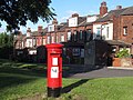 Postbox, Lower Town Street, Bramley - geograph.org.uk - 4598624.jpg 1,024 × 768; 231 KB
-
 Rosecliffe Mount - Ferncliffe Road - geograph.org.uk - 1127411.jpg 640 × 441; 172 KB
-

-
 Rosecliffe Terrace - Ferncliffe Road - geograph.org.uk - 1127409.jpg 640 × 445; 175 KB
-
 Warley Terrace, Rock Lane, Bramley - geograph.org.uk - 6447359.jpg 1,024 × 768; 248 KB
-
 Warrels Avenue, Bramley, Leeds - geograph.org.uk - 5667620.jpg 1,280 × 669; 438 KB


.jpg)
.jpg)


.jpg)


