Category:The Diamond, Port Sunlight
Jump to navigation
Jump to search
| Object location | | View all coordinates using: OpenStreetMap |
|---|
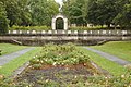
The Diamond is pair of planted areas in Port Sunlight, aligned roughly northwest to south east, with the war memorial at its intersection with The Causeway. This category collects items on The Diamond separately from their listing in the main Port Sunlight category.
Subcategories
This category has the following 5 subcategories, out of 5 total.
A
H
L
W
Media in category "The Diamond, Port Sunlight"
The following 7 files are in this category, out of 7 total.
-
 Lionhead fountain, Port Sunlight.jpg 4,252 × 3,030; 18.09 MB
-
 Terrace wall and arch, Port Sunlight 1.jpg 5,181 × 3,451; 23.8 MB
-
 Terrace wall and arch, Port Sunlight 2.jpg 4,543 × 3,080; 19.24 MB
-
 The Diamond and Lady Lever Art Gallery, Port Sunlight.jpg 4,802 × 3,298; 20.52 MB
-
 The Diamond, Port Sunlight 1.jpg 5,113 × 3,405; 24.27 MB
-
 The Diamond, Port Sunlight 2.jpg 4,797 × 3,383; 22.72 MB
-


