Category:The Elms, Meols
Jump to navigation
Jump to search
| Object location | | View all coordinates using: OpenStreetMap |
|---|
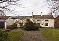
Cottage or possibly former farmhouse on Park Road, Meols, dating to 1649.
Media in category "The Elms, Meols"
The following 3 files are in this category, out of 3 total.
-
 Benchmark at The Elms, Park Road, Meols.jpg 3,462 × 5,198; 21.24 MB
-
 The Elms, Meols 1.jpg 5,078 × 3,362; 22.7 MB
-
 The Elms, Meols 2.jpg 4,880 × 3,375; 21.44 MB


