Category:The Enterprise Centre, Bromborough Pool
Jump to navigation
Jump to search
| Object location | | View all coordinates using: OpenStreetMap |
|---|
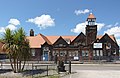
Grade II listed former village school in Wirral, Merseyside, England  | |||||
| Upload media | |||||
| Instance of | |||||
|---|---|---|---|---|---|
| Location | Wirral, Merseyside, North West England, England | ||||
| Heritage designation |
| ||||
 | |||||
Subcategories
This category has only the following subcategory.
Media in category "The Enterprise Centre, Bromborough Pool"
The following 8 files are in this category, out of 8 total.
-
 Bromborough Pool - DSC03501.JPG 3,648 × 2,736; 3.64 MB
-
 School bell, The Enterprise Centre, Bromborough Pool.jpg 5,032 × 3,372; 19.56 MB
-
 The Enterprise Centre - geograph.org.uk - 1759392.jpg 2,048 × 1,536; 674 KB
-
 The Enterprise Centre, Bromborough Pool 1.jpg 4,575 × 2,967; 15.92 MB
-
 The Enterprise Centre, Bromborough Pool 2.jpg 4,569 × 2,733; 14.75 MB
-
 The Enterprise Centre, Bromborough Pool 3.jpg 4,692 × 2,747; 12.28 MB
-
 The Enterprise Centre, Bromborough Pool 4.jpg 4,705 × 3,393; 17.54 MB
-
 Tower of The Enterprise Centre, Bromborough Pool.jpg 2,829 × 5,174; 15.96 MB


