Category:The Lyceum, Port Sunlight
Jump to navigation
Jump to search
| Object location | | View all coordinates using: OpenStreetMap |
|---|
building in Port Sunlight, Merseyside, England  | |||||
| Upload media | |||||
| Instance of | |||||
|---|---|---|---|---|---|
| Location | Port Sunlight, Wirral, Merseyside, North West England, England | ||||
| Heritage designation |
| ||||
 | |||||
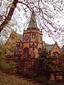
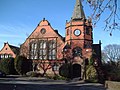
English: The Lyceum is a building in Bridge Street, Port Sunlight, Merseyside, England. Originally built as a school, it is now used for a variety of purposes, including housing a social club. It has been designated by English Heritage as a Grade II listed building.
Subcategories
This category has only the following subcategory.
Media in category "The Lyceum, Port Sunlight"
The following 7 files are in this category, out of 7 total.
-
 Lyceum, Port Sunlight (1).JPG 4,608 × 3,456; 3.66 MB
-
 Lyceum, Port Sunlight (2).JPG 4,608 × 3,456; 3.79 MB
-
 Lyceum, Port Sunlight 1.jpg 4,421 × 3,264; 19.45 MB
-
 Lyceum, Port Sunlight 2.jpg 4,997 × 3,350; 18.67 MB
-
 Lyceum, Port Sunlight.jpg 5,041 × 3,361; 6.31 MB
-
 Port Sunlight - DSC04536.JPG 2,736 × 3,648; 7.5 MB
-
 Social Club - geograph.org.uk - 154721.jpg 640 × 480; 107 KB
.JPG)
.JPG)


