Category:The Security Road
Jump to navigation
Jump to search
.jpg) | |||||
| Upload media | |||||
| Instance of | |||||
|---|---|---|---|---|---|
| Location | Holon, Tel Aviv District, Israel | ||||
| Heritage designation | |||||
 | |||||
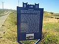
A temporary road which was built in the beginning of the 1948 Arab-Israeli War and connected Tel Aviv to the south of Israel, bypassing the arab blocks in Abu-Kabir and Yazur.
Subcategories
This category has the following 4 subcategories, out of 4 total.
Media in category "The Security Road"
The following 32 files are in this category, out of 32 total.
-
 94351 blue sign on security road barrel line PikiWiki Israel.jpg 3,024 × 4,032; 2.15 MB
-
 94352 blue sign on security road PikiWiki Israel.jpg 2,810 × 3,879; 2.61 MB
-
 94405 quotbarrel linequot along the 1948 security ro PikiWiki Israel.jpg 4,032 × 3,024; 2.9 MB
-
 Barrel line - Security road - Holon 1.jpg 2,592 × 4,608; 4.6 MB
-
 Barrel line - Security road - Holon 2.jpg 4,608 × 2,592; 7.18 MB
-
 Barrel line - Security road - Holon 3.jpg 4,608 × 2,592; 7.84 MB
-
 Barrel line - Security road - Holon 4.jpg 4,608 × 2,592; 7.73 MB
-
 Hayotzek memorial in tel aviv.jpg 2,048 × 1,536; 673 KB
-
 Hussamssa A ovedc 11.JPG 2,736 × 3,648; 2.01 MB
-
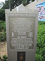 Memorial plaque to the "Citadel" on the security road (1948).JPG 3,456 × 4,608; 3.96 MB
-
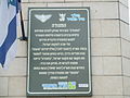 Memorial plaque to the "citadel" on the security road (1948).JPG 4,608 × 3,456; 3.08 MB
-
 Memorial plaques on the security road (1948).JPG 4,608 × 3,456; 4.08 MB
-
 PikiWiki Israel 68299 security through holon sands.jpg 2,635 × 2,413; 1.63 MB
-
 PikiWiki Israel 68300 security through holon sands.jpg 3,488 × 2,488; 2.77 MB
-
 PikiWiki Israel 68301 security through holon sands.jpg 3,532 × 2,425; 2.5 MB
-
 PikiWiki Israel 68302 security through holon sands.jpg 3,008 × 2,580; 2.35 MB
-
 PikiWiki Israel 68303 security through holon sands.jpg 2,562 × 3,307; 3.04 MB
-
 PikiWiki Israel 68304 security through holon sands.jpg 3,649 × 2,256; 2.56 MB
-
 PikiWiki Israel 68305 security through holon sands.jpg 3,046 × 1,968; 1.02 MB
-
 PikiWiki Israel 68306 security through holon sands.jpg 1,965 × 2,037; 1.1 MB
-
 PikiWiki Israel 68307 security through holon sands.jpg 3,194 × 2,366; 1.86 MB
-
 PikiWiki Israel 87576 remains of the security road.jpg 4,896 × 3,672; 5.73 MB
-
 PikiWiki Israel 87577 remains of the security road.jpg 4,896 × 3,672; 5.42 MB
-
 PikiWiki Israel 87578 remains of the security road.jpg 4,896 × 3,672; 6 MB
-
 PikiWiki Israel 87579 remains of the security road.jpg 4,896 × 3,672; 6.32 MB
-
 PikiWiki Israel 87580 remains of the security road.jpg 4,896 × 3,672; 5.5 MB
-
 Security road - Holon 1.jpg 2,592 × 4,608; 4.27 MB
-
 Security road - Holon 2.jpg 4,608 × 2,592; 6.29 MB
-
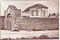 The citadel on the security road.jpg 640 × 419; 103 KB
-
 The Security Road (1).jpg 4,608 × 3,456; 4.88 MB
-
 The Security Road (2).jpg 4,608 × 3,456; 4.4 MB
-
 The Security Road.jpg 4,608 × 3,456; 5.36 MB


.JPG)
.JPG)
.JPG)


.jpg)
